HOME | DD
 JungSukOh — 2022 World Map with All* National Subdivisions
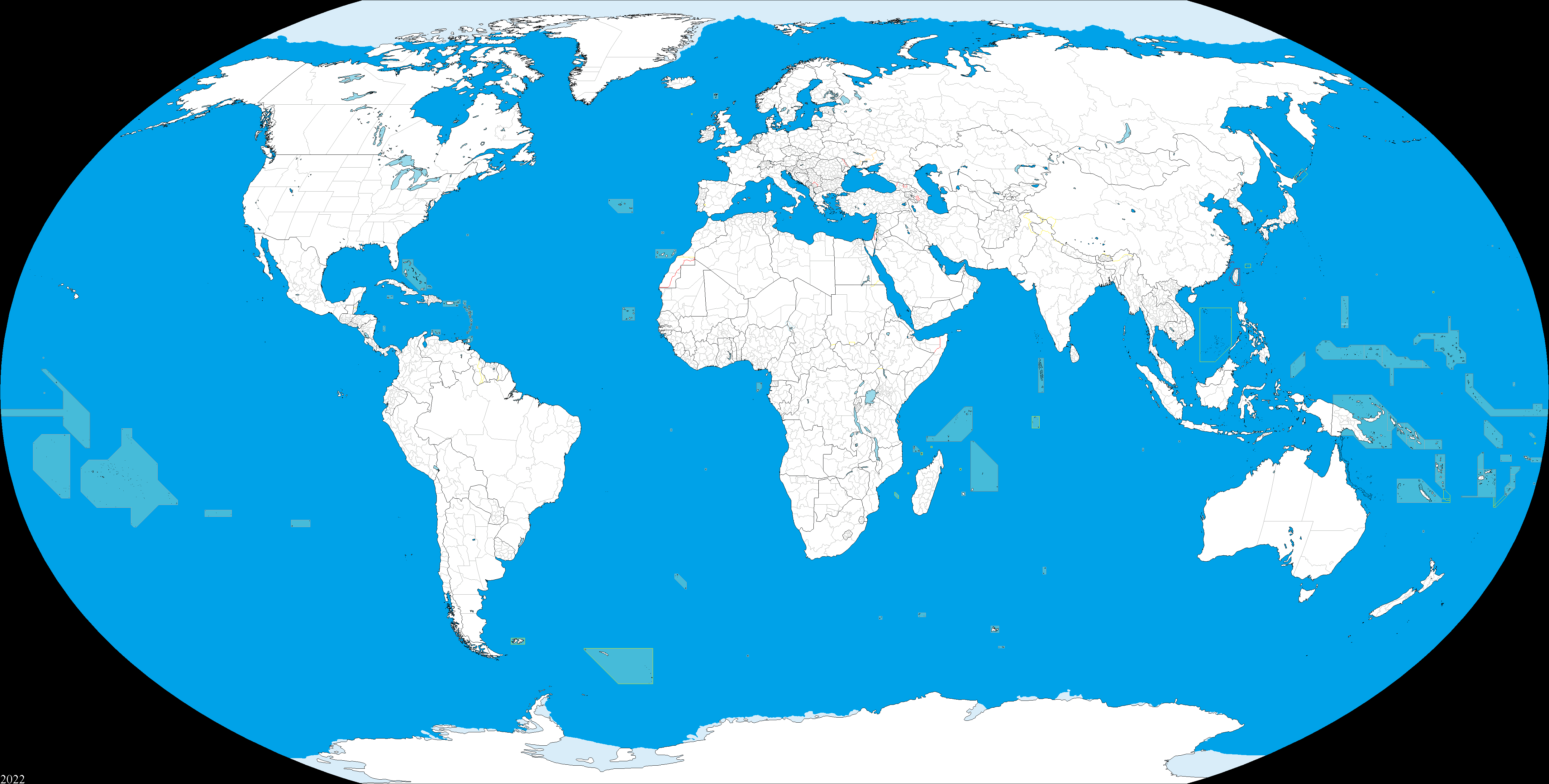
#2022 #cartography #geography #globe #international #mapping #maps #world #worldmap #mapmaking #templatefree #cartographymap
Published: 2022-10-30 18:18:38 +0000 UTC; Views: 8235; Favourites: 17; Downloads: 309
Redirect to original
Description
Six years later and here's an updated version of the 2016 World Map with All National Subdivisions. Made for ease of use with paint programs such as Microsoft Paint and Paint.net. List of notable changes included below. Should be up to date as of October 2022. Thanks to everyone who made suggestions on the last map. Free to use. Open to suggestions (might take a while for me to get to it though).*Technically not every subdivision is shown here. I want to avoid overcrowding the map (ex. Moldova) with too much information since this is supposed to be a user-friendly paint map template
2016 World Map Changes
1. Added new Djibloho district (established 2017) for Equatorial Guinea
2. Divided Indonesia's Kalimantan province into North and East
3. Changed Azerbaijan's economic regions to reflect the July 2021 changes
4. Altered the borders of the disputed Artsakh Republic to match the results of the 2020 Nagorno-Karabakh War
5. Added the Brčko District to Bosnia and Herzegovina
6. Added Serbia's proper districts
7. Corrected error that merged Belarus's Grodno and Vitebsk Oblasts
8. Deleted ISIS territories and removed disputed border from Iraq's Northern Kurdistan
9. Simplified Moldova's borders to reflect its "basic" regions (last version was too crowded for user painting)
10. Corrected error that combined Poland's Lubusz and Lower Silesian provinces
11. Slightly altered Saudi Arabia's border with Qatar and modified Bahrain's shape
12. Fixed South Ossetia's border with Georgia
13. Revised Lebanon's governates to reflect 2017 changes
14. Adjusted Cuba's provinces
15. Adjusted Florida's Coast and the Keys
16. Adjusted Haiti's departments
17. Adjusted and corrected the Dominican Republic's provinces
18. Adjusted El Salvador's departments
19. Fixed Honduras districts
20. Fixed Nicaragua departments
21. Adjusted Panama's districts and added Naso Tjer Di Comarca (est. 2020) ; adjusted Panama Canal shape
22. Added capitol region to Venezuela; adjusted other province borders and added Guri Reservoir (largest reservoir in South America)
23. Adjusted Ecuador's Province borders
24. Adjusted shape of Rio de Janeiro's coastline
25. Added Buenos Aires as autonomous
26. Adjusted Suriname districts
27. Adjusted Netherlands
28. Adjusted San Marino's position within Italy
29. Adjusted some of Germany's state borders
30. Fixed errors with Hungary's counties
31. Fixed errors with Hungary that merged Zala with Veszprem and Nograd with Borsod-Abauj-Zemplen
32. Simplified Bosnia and Herzegovina's borders along with Croatia
33. Fixed Kosovo's de-facto district borders
34. Adjusted Montenegro's municipalities and added Tuzi (est. 2018)
35. Adjusted Greek coast and islands
36. Added Bucharest as independent municipality in Romania
37. Added lake Vortsjarv in Estonia
38. Altered Norway's counties to reflect 2020 changes (8 counties were abolished)
39. Added Kyiv to Ukraine in addition to the Dnipro reservoirs (Kremenchuk and Kakhovka)
40. Adjusted and corrected Russian federal subject borders
41. Adjusted Japan's coast, islands, and Lake Biwa
42. Added Sejong Special Governing City and adjusted South Korea's coast
43. Adjusted North Korea's provinces; added Nampo province
44. Added Astana (Nur-Sultan), Almaty, and Shymkent as separate "state cities;" Baikonur under Russian administration is now separate
45. Major revisions to Iran's eastern provincial borders; added Qom and Alborz regions near Tehran.
46. Erased Qabailistan province in Pakistan (was merged with Khyber Pakhtunkhwa in 2018)
47. Added Ladakh Union Territory to India (est. 2019); added several more disputed areas around Kashmir and northern India
48. Altered Vietnam and Laos provincial borders
49. Corrected Cambodia's provincial borders (divided Kampong Cham from Tbong Kmoum)
50. Adjusted Malaysia state boundaries and islands
51. Added districts to Brunei
52. Adjusted islands and states of Indonesia
53. Adjusted Mauritania's regions
54. Added Taoudenit and Menaka regions (est. 2016)
55. Added Kedougou region to Senegal
56. Added North West Province to Sierra Leone (est. 2017)
57. Fixed error and reduced Cote d'Ivoire districts from 19 to 14 to reflect 2011 changes
58. Increased Ghana's regions from 10 to 16 reflecting the results of a 2018 referendum
59. Added capital region to Niger
60. Adjusted and fixed Chad's regional borders
61. Added special capital commune to Central African Republic
62. Adjusted Taiwan's county borders and added Kinmen and Matsu disputed islands
63. Added Mymensingh division to Bangladesh (est. 2015)
64. Changed Nepal from 5 regions to 7 provinces
65. Adjusted Bhutan's dzongkhags; added Doklam dispute (2017), Sakteng dispute (2020), and Pasamlung dispute with China
(Bhutan seems to have given-up claim to the northern Kula Kangri disputed territory)
66. Adjusted Philippines coast and island; added three major lakes (Laguna de Bay, Lanao, Taal)
67. Fixed Papua New Guinea's Provincial borders
68. Adjusted New Zealand's coast
69. Adjusted Kuwait's governorates
70. Fixed Qatar's municipalities
71. Added Chobe and the seven urban districts to Botswana
72. Adjusted Lesotho's administrative borders
73. Added Kavango West to Namibia
74. Adjusted Malawi
75. Major fixes to Zambia's provincial borders; added Muchinga Province (est. 2011); added Lake Mweru Wantipa and adjusted Lake Bangweulu
(Shibuyunji district is part of Central Province as of 2018, not Lusaka Province)
(Chama district was returned to Eastern Province from Muchinga Province in 2021)
76. Added Lake Assal to Djibouti
78. Added Qeqertalik and Avannaata (est. 2018) to Greenland
79. Major changes to Egypt's governorates; Suez Canal adjusted
80. Fixed Oman's governorates
81. Redid UAE's Emirate borders and adjusted coastline
82. Changed Morocco's regional borders to reflect 2015 changes; altered Sahrawi Arab DR area of control to reflect 2020 change
83. Made major changes to Algeria's provinces to reflect 2019 reforms
84. Fixed Tanzania's regional borders and added Lake Rukwa
85. Adjusted Ethiopia's regional borders and added Sidama Region (est. 2020) and SNNPR Region (est. 2021)
86. Adjusted South Sudan's state borders to reflect 2020 changes
87. Changed Madagascar from six provinces to 23 regions
88. Adjusted Somalia and Somaliland's regional borders (Somaliland's constitution stipulates six regions; not five)
89. Transitioned Kenya from its regional borders to its 2010 county borders
90. Fixed Ireland's county borders
91. Adjusted Great Britain's coast
92. Adjusted Marshall Island's atolls
93. Adjusted Hawaiian islands
94. Redrew Saudi Arabia's province borders
95. Fixed Iceland regional borders
96. Added Sevastopol subject of Russia (disputed)
97. Changed border of Ukraine's Kherson, Zaporizhzhia, Donetsk, and Luhansk oblasts to reflect their disputed nature following 2022 Russian annexation order; also deleted Donetsk and Luhansk People's Republic borders following their dissolution and integration
98. Altered Kazakhstan's regional borders to reflect new 2022 changes (three new regions: Abai, Ulytau, and Jetisu).
99. Shrunk Great Salt Lake (United States) and Ural Sea (Kazakhstan)
100. Adjusted the Kuril Islands
101. Added the 9 statistical regions of England


