HOME | DD
 smarticle17 — Worldbuilding Project: Map of the Southlands

#topography #computerart #mapping #maps #sciencefictionfantasy #worldbuilding #mapmaking #worldbuildingart
Published: 2022-01-22 03:03:36 +0000 UTC; Views: 4308; Favourites: 38; Downloads: 8
Redirect to original
Description
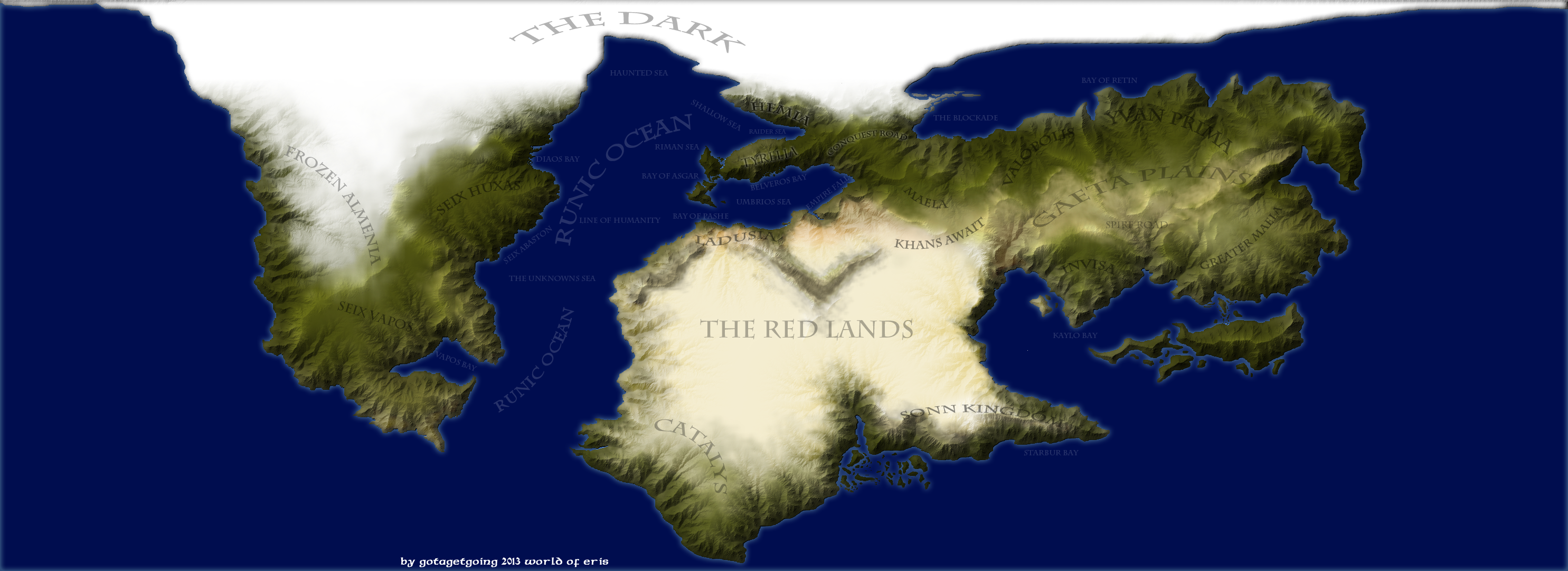
The map pictured above depicts the full extents of the Southlands, or the bottom third of the planet's largest continent. Excluding the polar ice caps, its area covers roughly 6.0 million sq. km (i.e., about 1.5 times as large as the Indian Subcontinent). The Southlands can be divided up into multiple smaller regions, one of which is the Eastern Peninsula from whence the Mai hail. The little red box indicated on the map shows the locale inhabited by the Southern Mai. For frame of reference, that little box is about half the size of Greece. It gives a pretty good idea of just how much bigger the World is compared to the places most familiar to this people group. The lands north of this small region of land includes the lands of the Central Mai, the Hemme, and the Kaelho. The mountains yet further north are called the Angvollo Vara and are inhabited by a group of nonhuman sapients who the Mai call the Soboleru. They call themselves the Akka'o. The lands south of this region include the lands of the Anjin and a maritime archipelago covered in a temperate rainforest inhabited by primitive hunter-gatherers. The mountains that divide the western and eastern halves of the Eastern Peninsula are known as the Basso Vara, or Pillar Mountains. The gulf that lies west of the Eastern Peninsula has no name, though some places of note include the isle of Gashvi inhabited by an offshoot of the Mai called the Gash Neyngosho, and the bay where the Mayic explorer Swassuyok made land and met the Dhuroh riding herdsmen of the Western plains. There are many more places and peoples than those I have already mentioned, however, I will hold off on describing them for the time being. I tend to write my stories and descriptions with a Mayic perspective in mind, so I don't want to talk too much about locations they themselves have not visited (yet).As before, the colors used on this map are somewhat inaccurate. The flora of this world comes from a variety of different planets all with their own unique biospheres. Some of them have green leaves like most of the plant life of Earth, but others have more yellowish hues, while others are shades of red and even burgundy. One feature that is sadly obscured by my choice of color is the great no-man's land that divides the eastern and western halves of the subcontinent in half. Near towards the middle of the Angvollo Vara is a massive strip of land that is dominated by the red vegetation and beasts native to the World of the Soboleru. Due to the nature of their biochemistry, all of the organisms that live that are effectively useless to humans. Both their proteins and sugars are based on the opposite chirality to that of life here on Earth, so our bodies are incapable of digesting that matter in any meaningful way. It doesn't provide humans and other terrestrial lifeforms with any nutrition. One could thus eat and eat every day in such a land but inevitably die of starvation. This great obstacle has stopped any humans from crossing between the different sides of the continent. The only reason that the Mai are in the Eastern Peninsula is because there was a brief period of time some 10,000 years ago that a 'Green Corridor' opened up and allowed their ancestors to cross over to the other side of the subcontinent. The Gash Neyngosho and several other Mayic offshoots that do inhabit that region live in a relatively small pocket of land where green plants still thrive despite being surrounded on all sides by an utterly alien ecosystem. This is the only remnant of that corridor having every existed.
(I must admit I have been a bit of a slump as of late. I kind of feel that my project isn't going anywhere. I've greatly enjoyed illustrating the creatures of this strange World, though the World itself felt hazy. I been having trouble coming up with ideas because I didn't really know what things looked like. I made this drawing of the Southlands quite some time ago, however it merely showed the landmasses and the sea. There was no reference to scale, nor was there any colors used to distinguish the different climates. I finally sat down to remedy this, and though it took a great deal of time to finish, I think that the result of my toils, or perhaps the toil itself, has reinvigorated me. It's given me a better idea of where things are in the grand scheme of things, and helps me to better visualize the World these people live in. Going forward I am going to be doing another piece on the Dune Folk [a.k.a., the Akka'o or the Soboleru or the Zwovoler among many other names no doubt], and I also intend to work on a script for the Mayic language. Some of my pieces provide little snippets of that writing system, but I still need to sit down and put together a full roster of characters. Writing systems are another of my interests, so I think that it will be great fun working that out. While finishing this map was quite tedious at times, I enjoy the result, and I do hope that you all liked this piece too).