HOME | DD
 SRegan — Kijet Snartar UCS Map
#alternatehistory #fantasy #highfantasy #map #paralleluniverse #alternategeography
Published: 2014-11-15 10:40:10 +0000 UTC; Views: 1079; Favourites: 1; Downloads: 5
Redirect to original
Description
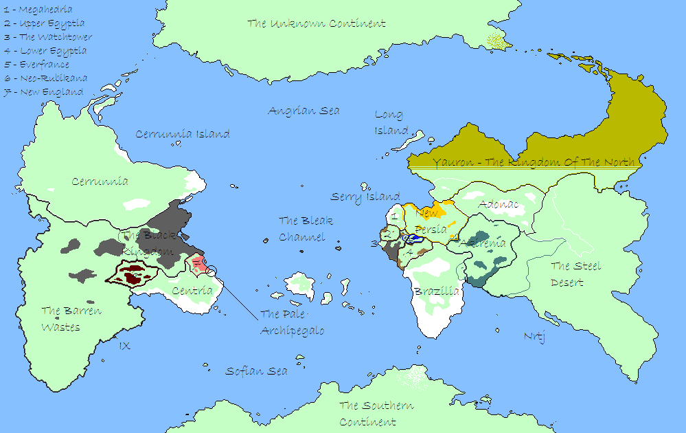
Probably my first attempt at a scratchbuilt map with the same dimensions and colour scheme as the AlternateHistory.com worlda. I'm not too sure about the island chains but overall feel the shape of the landmasses came out pretty plausible - I drew the original shapes then roughened them up with a second pass.
This was an update of a hand-drawn map I created ages ago for my setting "Kijet Snartar". The premise is that a multiverse exists, comprising countless parallel Earths that have split at various historically critical points. The further back the POD between any two universes, the further apart they are in the multiversal n-space, so the Earth where the US didn't invade Iraq is closer to us than the Earth where Napoleon won the Battle of Waterloo). The multiverse also has a degree of sentience and a will of its own, and will act to protect the balance of the universal orrery.
Any object or individual that is in danger of upsetting this balance will be snatched away 'I.T.E.' (Into The Ether) and deposited on the Earth with the greatest mean distance from the rest of the multiverse - the world which has become known to its inhabitants as Kijet Snartar (in the most common shared language in the multiverse 'The Tiger World'). The setting itself is a semi-comedy-fantasy where every character comes from a different AH premise - for example, one of the main characters, Arjuna, derives from a world where India was the first power to undergo Industrial Revolution. Here's a previous summary I wrote up for KS:-
"The premise is simply that everything and everyone that goes missing and is never found again has been ITE'd (Into The Ether'd) and dumped in Kijet Snartar, the so-called "landfill of the multiverse". The survivors of this process are left to work out why they were removed from their home universe, and forced to work together to survive. Some of the more obvious dangers to the stability of the multiverse, however, aren't interested in playing fair, and are busy carving out their own empires..."
The map is intended to vaguely recall some of the continent shapes from OTL, given that Kijet Snartar is an Earth that has diverged a billion or so years ago - the western chunk of Nrtj is supposed to look something like Africa but obviously isn't, given its smaller size. The colouring represents the fact that the population of Kijet Snartar is absolutely miniscule, with most of the people who are ITE'd there clustered into a few town-sized encampment. Consequently whilst a good chunk of both IX and Nrtj is formally divided between established societies (generally representing the most common cultures and languages), there's a lot of border disputes, settlements technically within the border of an entity they don't regard as having jurisdiction, etc. For example, the latest toehold Monarch (the Black Kingdom's head honcho - think Native American Hitler with Mind Control) has managed to gain on Nrtj is recognised by almost no-one, especially as it cuts a pre-existing state (Egyptia) in half.
Akirema and Adonac/Adanoc/Adanac have also diplomatically divided the vaguely habitable areas of the Steel Desert between them - however, since they don't have any settlements there and in fact maintain a border patrol at their 'real' boundaries against the various Steel Desert beasties, it's theoretical at best. The funny stripey thing in Yauron represents the fact that the latitude to which the King of the North can project force varies throughout the year due to the fact that his military is composed almost entirely of robots made out of ice (yes, I know).
I later reworked this map to a far higher level of technical accomplishment in Photoshop.