HOME | DD
 Suchipithecus — ATLA!Earth 2.0

#atla #au #rotated #avatarthelastairbender #avatarthelegendofkorra
Published: 2020-10-18 15:19:13 +0000 UTC; Views: 1293; Favourites: 12; Downloads: 0
Redirect to original
Description
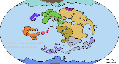
(Please, there are 57,740,000 pixels in that basemap. I'm not complaining, the detail was phenomenal, I just couldn't get every single square inch of terra nullis.)Again, it returns. I must say, Pacific-centering and then rotating 180 degrees really makes our Earth look like the Avatar planet. Of course it's not perfect; for example, I still have no idea where the Si Wong is meant to go. Damn Sahara Pump Theory. Nevertheless, I feel it has worked out splendidly otherwise, as long as you ignore the fact that the Northern Water Tribe is at the South Pole and vice versa (conceptions of north and south can change, okay? Besides, I feel it better suits the geography of the tribes as shown). Air Temples are at New Zealand, Ireland, Valdivian Andes, and Alaska, for Northern, Eastern, Western and Southern respectively. The Eastern and Western Temples look quite close on this projection, but remember, the full length of the Atlantic is between them. I suspect the Foggy Swamp is in SE Asia, Kyoshi Island off of Kamchatka, and Gaoling and Zaofu in China. Zaofu doesn't exist at the time this map shows, shortly before the Hundred Years War with the traditional borders, but the land exists. No idea where Ba Sing Se or the Republic would go.
As always, if anyone has any ideas or suggestion for improvements or locating locations, I'm all ears in the comments or notes. Thank you for clicking.
Basemap by Ashtagon: www.deviantart.com/ashtagon/ar…