HOME | DD
 Anarlaurendil — Keltios Map - Lake of Time
by
Anarlaurendil — Keltios Map - Lake of Time
by
Published: 2020-01-16 17:13:42 +0000 UTC; Views: 29543; Favourites: 673; Downloads: 182
Redirect to original
Description
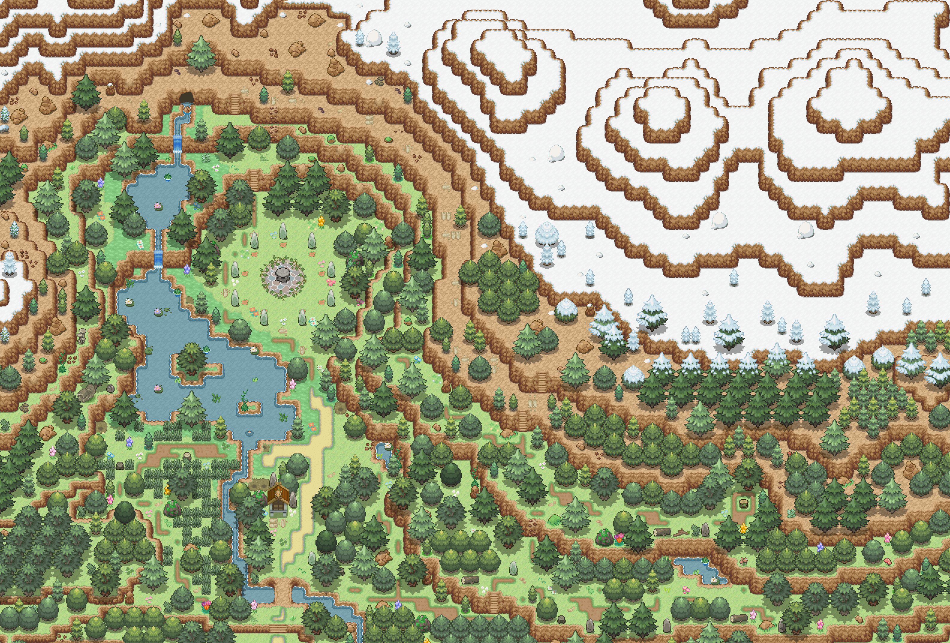
My second map made on RPG Maker for my fangame Pokemon Sacred Phoenix.
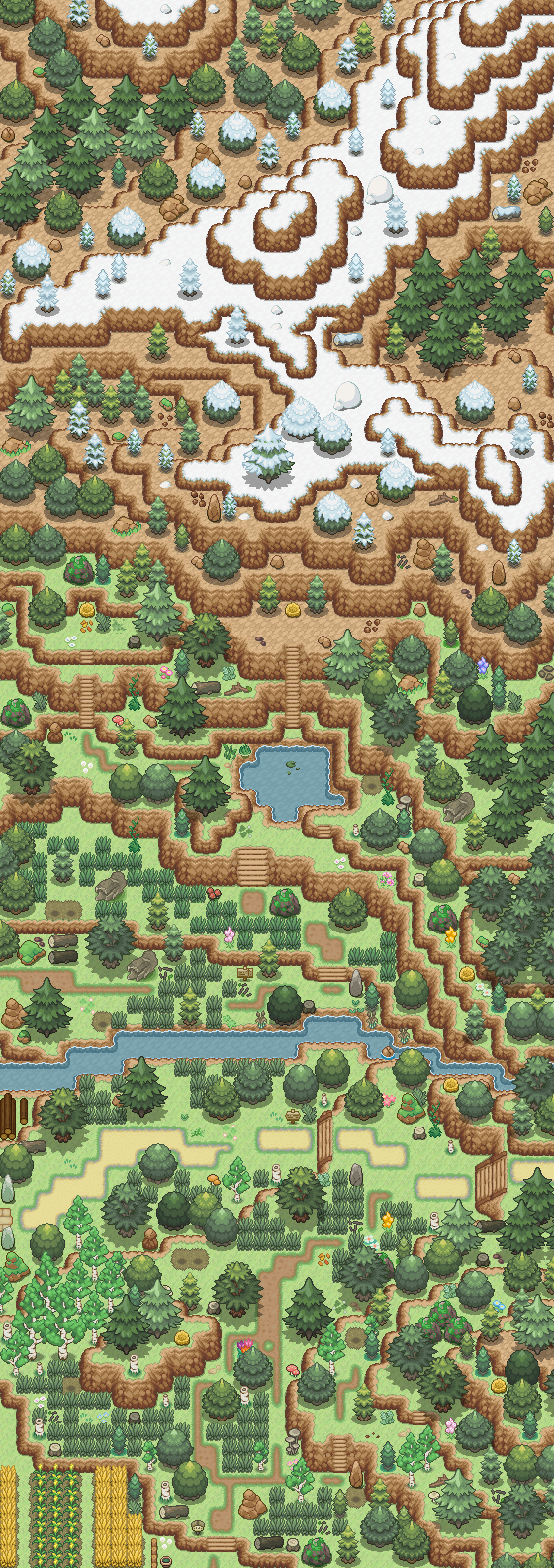
Here is the Lake of Time: the second map that the player will discover by plunging into the realm of Keltios.
Only the lower parts will be accessible during the start of the game, the most remote areas will require Surf, Rock Climb or Waterfall to access them.
Lake of Time lore:
Nestled between the two highest mountains of Everlasting Mounts on Alienor Shire, the Lake of Time is a holy forest and also the refuge of Celebi. At least that's what the rumor says. One thing is certain: the Energy of Nature is very present.
The mountain range forming a natural border with Kalos located to the north, you can only access it from Sylvan Town from the south. Its isolated geographical position contributes to the purity of this place.
Sensing the high vibrations of this lake, the clergy of Celebi erected at the dawn of keltic era a wooden altar, as well as a keltic stone circle further north. Amazed by the beauty of the place, the few who make the pilgrimage to the stone circle see their happiest memories to surface.
Borders:
• North: Kalos border / Everlasting Mounts (Impassable)
• Northeast: Lugh ravines (Kalos) (Impassable)
• East: Vale of Lugh (Breliande Shire) (Impassable)
• South: Sylvan Town
• Southwest: Route 1 - Eagle Path
Experiencing tile-making and advanced mapping:
It is 99x67 map (3x2 chunks with the three tiles borders). With such a level of detail, this is a large map for me. Each trail is unique and will have its uses in gameplay. No two places are the same. You will really have the sensation of strolling in a mountain forest with its steep paths if you move away from the shores of the lake.
One of the funniest challenges was to stay as faithful as possible to my worldmap, especially on its relief curves. As a result, I had to extend the map (initially 2x2 chunks) with an additional column of chunks to the east. The highest mountain in this shire (which borders Kalos to north) is present, which played on the number of "cliffs" that I had to stack. A dozen of double cliffs (which corresponds to 2000 meters in elevation between the highest and lowest point of this map) was enough to give this feeling of relief.
Everything has to be mapped, including the edges, as I foresee a soaring feature which will allow you to fly freely over the entire overworld.
The tileset used in the Phoenix Hill has also evolved. Optimized to have a maximum of elements in first layer, I also multiply the number of custom tiles, whether it be:
• Pre-mapping (combination of tiles on the same layer. The most common case is the foot of a tree with its soil tile.)
• Manual autotiling of shorelines and paths with agancement optimized for the human eye. (48 combinations each time) I reserve automatic autotiles only for animated areas, namely water and waterfalls.
• Sacred elements specific to Keltios (altars, stone circles)
• Body of water whose shore straddles 2 tiles. (No ambiguity on what is navigable or not.)
• Optimization of the space taken by the trees. (Slight line offsets to free up tiles occupied by 1 or 2 pixels from a tree edge.)
• Optimization of tree groupings (removal of ledge tiles which duplicated the tree alone). I gained more than 50% of space in these places of the tileset!
• Custom connection tile for connecting relief elements. (Transition from a double cliff into 2 simple cliffs, sagging cliff, custom rock stairs, vertical and horizontal stone bridge ... )
In the end, the balance of working time is:
• 60 hours of tile-making and re-arrangement of tiles. (Which add up to the 80 hours for Phoenix Hill)
• 35 hours of mapping (against 18 hours for Phoenix Hill, but this map is 50% larger and certainly more wild.)
I hope that in the long term, this tile-making / mapping time ratio will decrease.
I also lost a lot of time when I redeployed tiles elsewhere on the tileset (especially when optimizing tree groupings).
But it is important to start on solid foundations with a complete and ergonomic tileset, because all the other maps will have the same one.
-- Crédits --
Tiles used come from:
• Amras Anárion (myself) (CC BY)
• Magiscarf (Creative Commons Attribution-Noncommercial-Share Alike)
• Chaoticcherrycake (CC BY-NC)
Related content


Comments: 54


This looks amazing. Especially if you add a soar feature. With this said I'll give you some thoughts, keep in mind this is only based on looks since I'm not playtesting it, so I can't really say what works and what doesn't.
I hope the game has a full screen mode, it can very easily feel a bit loaded from a small one, and the hard work won't be able to be appreciated.
I do imagine overworld pokemon like in rangers. Running around and then you fight them. Doesn't seem to run so smooth with grass and classic mechanics, to me, because there isn't much tall grass and trainers everywhere might take off the feeling of nature this place gives.
If the top of the mountain is accessible it would be very interesting to have a temple there as well, and maybe one house or another.
I would encourage you to make some more caves, maybe not so big and glorious as the one where the river comes out, but to make exploration feel more worth it, your map is full of small passages, it would be great to feel like they all lead to something.
Hope to see more of it, this is one amazing piece of work.
👍: 0 ⏩: 1

Hello,
Thank you for your comment. I will therefore answer some of your questions to enlighten you on my mapping choices.
The display is on 20x15 tiles. This is called in video game jargon the peripheral vision of the player.
You can get a preview of the real rendering here.
If I use a soaring mechanism, the map should be zoomed to 50% to simulate the altitude, which will allow to visualize 4 times more extent.
(But it would be planned in the long term. At the moment, I don't know how to manage this.)
The fact that tall grasses are sequestered on the western part of the river has a justification: this is the second map on which the hero will be teleported and at this stage of the game, he has neither Pokéballs nor Pokédex yet. So he shouldn't be able to meet people right away. The lore of the place also says that it is isolated, embedded in the mountain, which explains the absence of trainer.
So there will be wild Pokemon available, but once the surf is unlocked.
I take note of your idea of a temple and a cave in the mountains.  (Smile)")
For the moment, I have to block access to the players on the 10 most northerly, south and east squares. The only maplink planned in the short and medium term is in the south.
When my universe is larger, I can reflect on these minor changes.
👍: 0 ⏩: 0
<= Prev |