HOME | DD
 BonesRobert — South Caucasus Map Status

#azerbaijan #borders #caucasus #countries #georgia #map #russia #armenia #historical #history #maps #pixelart #sovietunion #mapsandflags
Published: 2023-06-29 08:34:04 +0000 UTC; Views: 2297; Favourites: 22; Downloads: 2
Redirect to original
Description
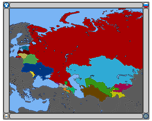
Some maps displaying the political boundaries/territories in the South Caucasus which also includes unrecognized states.1989: Under the Soviet Union, displayed in red are the Soviet Socialist Republics followed by Autonomous SSRs in blue and in yellow are the Autonomous Oblasts.
2020: Artsakh still retains control over large portions of Azerbaijan's Karabakh and East Zangezur regions from the First Nagorno-Karabakh War during the 90s. Abkhazia and South Ossetia still holds control over their territory since the 2008 Russian-Georgian War.
2023: After the Second Nagorno-Karabakh War in 2020 Artsakh looses massive territory, leaving the Lachin Corridor the only strip connecting to Armenia. As per agreement, the Lachin Corridor would be under the control of Russian Peacekeepers to monitor and keep the peace in the area. The year 2025 would see the expiration of Russian Peacekeepers term in the region if both parties agree to no longer requiring their presence.
De jure: Display of the region according to the United Nations/International Community and it's respective country. Abkhazia and South Ossetia is international seen a part of Georgia. Artsakh/Nagorno-Karabakh is international seen a part of Azerbaijan.