HOME | DD
 JelloJolteon2000 — The Cajiro Region
Published: 2012-08-14 20:24:21 +0000 UTC; Views: 10519; Favourites: 179; Downloads: 118
Redirect to original
Description
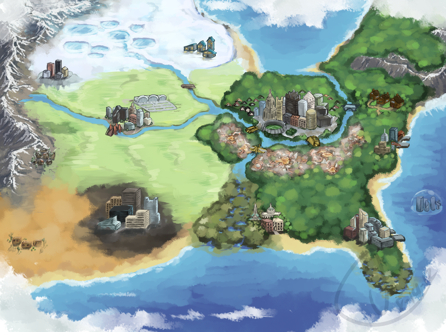
Yup, here's the pretty version. Told you I'd get it up as soon as I could.The cities are really not to scale, nothing actually is except the map itself, but it's the best I can do. And I say that right now that's pretty good.
None of the cities have names. Zennaes used the letters of the Greek alphabet, but I think here it would be normal-ish city names. My guess for route numbers at least includes somewhere in the neighborhood of 60-80. Remember, this is basically a giant Middle Atlantic and that's what the routes basically are. As you can see, we have a Strato-City, near the mountains, and that's not a total asspull, I promise. I mean, with pokemon, certainly you can float a city, right? Right.
So the deal with that is that they did float a city, and it just so happens that everything is almost always just below the dew point up there, so thus clouds form. It's windy and chilly and pretty wet, but hey, that floats some people's boats.
Star city award goes to Pittsburgh, the only decent city anywhere within a probable 200 mile radius of me. And it's also a bit of me rectifying something that bothers me about every region so far, save Unova, I believe: The Pokemon League is always marked as a city, but it's always just one stupid building. Special points go to Ever Grande City in Hoenn for being a Pokemon Center. SO now the Pokemon league is in the biggest city, here, Pittsburgh.
I'm not sure where the Gyms would be here either, at least not 100%. Strato city, underwater city, Miami, Kansas City, New Orleans, and Dallas would have them, but that leaves two smaller places to get the other two gyms. Sadly, they're also the ones more conducive to a climate-themed gym so it's a tough choice.
As far as islands go, the ones Zennaes had were conveniently replaced by areas with the same function, so I'm not sure if/where any are right now. For anyone who cares, around the middle of the game, you get access to an area in the great plains specifically with the purpose of EV training.
Oh, and a black sand desert.
If any of you can think of anything else that needs said here, do tell, but for now, I'd like to nurse a very sore left hand.
Pokemon © Game Freak, Cajiro and Art © Me.
Related content


Comments: 102

I'd be happy to look at whatever you post, though I'm not on here as much as I used to be! Designing regions is what you make it and if you have fun with it and the lore associated with it, I'm sure it will turn out great.
")
👍: 0 ⏩: 1

Thank you so much! I was going to post it last week but decided to wait a bit longer, so that I could add more lore to the region. I'm a huge geography nut, and also love Pokemon, so region making is kind of where I find a middle ground.
👍: 0 ⏩: 0

Wow ok I'm so late to this :/ Two quick questions tho: One, what's that weird steaming place south of the largest city, and have you thought of an evil organization for this region or naw?
👍: 0 ⏩: 1
Oh gosh it's cool! I like... I never check dA enough any more.
The area to the south of the main city is the Rust Belt, which is a reference to the real life band of decaying industrial towns of the same name in real life. Basically it's a giant polluted trash heap of industry that started attracting so many rare poison and steel types that officials in the region would have been remiss to restore it to its original pristine natural beauty. In the end, it serves kind of as a gigantic landfill for the region so that the rest of it can stay beautiful.
As for the evil organization? I dally on that; I haven't really given it all that much thought, but I do remember something about the evil team having a sort of steampunk style and time travel shenanigans being involved. I think the evil team leader kind of got stuck outside her native time period and went off the deep end.
👍: 0 ⏩: 1
Wow that's so cool! Originally I thought is was a weird mystical mushroom garden haha, although I love the ties to reality! The steampunk team idea sounds great as well! It's all so great! XD
👍: 0 ⏩: 0

wait that's the point
weird
i should've read more closely, i did a ctrl-f for "america" and didn't come up with anything
👍: 0 ⏩: 1
I think I ended up more calling it the US since I didn't really do much of anything with Canada and Mexico/Central America.
👍: 0 ⏩: 1
is Unova somewhere in here? :y
👍: 0 ⏩: 1
Unova is actually directly to the northeast, and Orre to the southwest.
👍: 0 ⏩: 0

Awesome! This is fantastic! I'm currently in the process of making my own region map for my Fakemon. Although I am finding it quite difficult and wondered if you had any advice or pointers for making a good region map. I have an idea in mind for the location I want to base it on: The Galápagos Islands (not all of them, just a select few, maybe 3-4), but I'm not sure where to even begin. Would you said it's better if I just use the location as a guide for now and just design Fakemon based on creatures from the Galápagos Islands and then design the map at a later date, or design the map first?
Hope I'm not asking too much, but the map is the one thing slowing down my project's production/development.
Thanks in advance!
👍: 0 ⏩: 1
Hey, not a problem at all! Thanks for your kind words!
I don't know if I can necessarily give bona fide advice on the subject, since this region map was actually a pretty far-flung afterthought and a very self indulgent one at that. But you should be able to do it in whatever order you want! Don't let a lack of inspiration on one front halt your progress on the other.
My own personal suggestion would probably be to do some designs first though, with the simple logic being in favor of creature variety. You have a lot more ground to cover with designs of fakemon than you do with a region, and it can be harder to come up with solid concepts if you box yourself in prematurely. Meanwhile, as the creatures in the region develop, you'll have a better idea of what environment was needed to shape them into what you've come up with.
Once you have some fakemon made and an idea of what their environment might look like, this is the time to put that together a little more. I wouldn't solidify anything unless you're really satisfied with the representation you've got. This way you've still got some room if you come up with a great concept, but at the same time you can begin to work the reverse process: you've seen what creatures come from what environments, so now you can make conjectures about how the environments you've envisioned might shape other fakemon. I think this sort of back-and-forth will really help with cohesion in the long run.
Although this map was, like I said, mostly an afterthought, I can give you an example of what I mean. A lot of my fakes were designed a long time ago, so they were kind of everywhere as far as environments. There were definitely forests, coastline, and mountains, and most of it was pretty temperate with an edge of tropical based on what I'd had going on in my mind's eye. So I needed an area of the world that was temperate but with a pretty wide range of landscapes. It was probably a subconscious "design what you know" thing, since a pretty solid analog was the United States, however far I wanted to pull it. I exaggerated certain features (the forests and the Rust Belt in particular) based on what I seemed to have going, and added a few self-indulgent things here and there like the black sand deserts, the swamp, and the underwater and sky cities. With the map done, I was about at a time that I was getting sick of a lot of old designs and redoing them. Now that I had a map, I could better envision what went where and why things might look the way they look. I ended up with a manatee for a starter because of the swamps (or vice verse I can't quite recall), and a lot of the ground and rock type fakes that have a distinctly western feel to them. The Rust Belt had a lot of ecological effects on the region and in the end it made me try to weight a porrtion of my dex with more poison and steel types then it had. There's a definite co-influence that happened.
This is probably a lot more than you were expecting, but it all basically amounts to just trying to let things happen naturally. Art mimicking life or something like that.
One last piece of advice based on something I didn't really get to do much on purpose: dex numbering is a really nice touch. Try to think about the path you'd take through your region to get from your home to the pokemon league! There would be clusters of certain types pokemon numerically based on when you see them in your journey.
Good luck! If there's any other questions you'd like to ask, I'm more than happy to give them my best shot. This was a lot of fun to answer.
👍: 0 ⏩: 1
Thank you so very much for replying and offering so much useful advice! I appreciate it so much and I know I will be referring to this comment so many times up until the completion of my project. You have opened my eyes to a lot I didn't know and things are much clearer (the dex numbering is especially as I was chucking a random number on a fakemon). I appreciate the offer of asking more questions, so thank you very much again!
👍: 0 ⏩: 1
Of course! Best of luck!
👍: 0 ⏩: 0

Hmm... Judging by the peninsula, big city in the east, and mr. lake over there, this is obviously...
China. Yes, it's TOTALLY based off china.
👍: 0 ⏩: 1
Oh my goodness you got me it's clearly china
👍: 0 ⏩: 0
Heh, thank you!
👍: 0 ⏩: 0

Thank you very much!!
👍: 0 ⏩: 0


XD unova is manhatten island.. just kinda tilted all weird. methinks fix that, and this giant half country region could be a bunch of regions connected. haha but the map looks really cool
👍: 0 ⏩: 0
LOL maaaaybe? If you wish to go looking for it, head northeast. Those mountains connect somewhere up the line.
 (Smile)")
👍: 0 ⏩: 0
is pittsburg and cleaveland smooshed together? XD cause u obliterated ohio if u did
👍: 0 ⏩: 1
Ahhh sorry Ohio you can be that part between the snow and the woods of pitt. Maybe share with St. Louis?
👍: 0 ⏩: 1
XD but... ur filling the spot ohio would be.. theres the shore we have to worry about. pittsburg and cleveland could possibly have a merger? lol like downtown cleveland and one side of pittsburg if theres a river on the east side of it with bridges they can connect and merge
👍: 0 ⏩: 1
Same with Arkansas, Delaware, New Jersey, West Virginia, Kentucky, at least one of the Carolinas, Tennessee, Mississippi or Alabama, Indiana, more than likely Iowa and Nebraska, the Dakotas, Wisconsin, and probably Oklahoma. The map is a caricature and I think I've managed to cut out more states than I've included!  (Wink)")
👍: 0 ⏩: 1
XD well its huge still
👍: 0 ⏩: 0

New to DeviantArt. Love how humble you guys are here, generally speaking.
This piece is excellent. Inspired me to draw a region myself.
👍: 0 ⏩: 1
Haha, welcome! Enjoy your stay here!
A lot of people are really great here. Of course, you've got some idiots too (just like anywhere) and while they're probably inescapable, if you pay them little mind you'll be fine. Just associate with the nice ones instead.
And thank you! I'm glad I could be an inspiration, and if you ever upload the drawing I'd love to see it!
👍: 0 ⏩: 0

Awww thank you!!~
👍: 0 ⏩: 0


wow, would you be willing to let me commission you for map artwork?
👍: 0 ⏩: 1
At some point I intend to open commissions and yes, this would be one of the things listed.
👍: 0 ⏩: 1
OMG, how much would they be
👍: 0 ⏩: 1
Mostly dependent on size of region, but the land itself (excluding cities/towns) would be $25 or $30 or so. I'm having trouble deciding on a fair price between the time and effort it took me to do this (a painful amount) and the fact that this was also very experimental where other results may differ. The cities/towns would be extra: $.50 to $1 for towns and $1 to $2 for cities. Again, that adds up, but let me tell you that the cities and towns took a lot of detail and time. I don't want to end up having to do a bajillion maps, y'know?
👍: 0 ⏩: 1
so if i wanted this, it has all 4 of my regions, how much would it be [link]
👍: 0 ⏩: 1
Since the map itself isn't too complex, I'd say 30 for that. If I counted correctly, you also have 62 towns/cities (big dots). Going to say a dollar on everything since I don't know what is what. I don't think I'd include landmarks and I didn't count small dots. So it would probably be around $92 keeping in mind that the cities wouldn't look overly exciting since I would have no descriptions of how they should look.
👍: 0 ⏩: 1
ah OK well once i get the details and you open commissions then maybe
👍: 0 ⏩: 0

Awww thank you thank you!
👍: 0 ⏩: 0

It kind of resembles america. Was that what you were going for?
👍: 0 ⏩: 1
Mostly east of the Rockies, yes.
👍: 0 ⏩: 1
cool, very well done!
👍: 0 ⏩: 1

Hmmm, its absolutely great, is it okay if i use some of the techniques you used on this? Like the mountains and trees, i always have trouble with those C:
👍: 0 ⏩: 1
Sure! The mountains were just a lucky thing, but my best advice (Assuming you're using SAI) would be to shade with an airbrush and then make the shading very hard on one side using the brush, and gradually fading it to slightly darker than base color with some ripples, and then go back with the base color and make sharper contrast on mostly the light side, again with the whole ripple sort of thing, and if you feel the need do the same on the other side. The snow I think I used a spread brush for, just keeping to the peaks and inside the ridges. That was on a new layer that I switched to overlay or some such thing.
AS far as the trees are concerned, it was basically starting on a darker green layer, adding lighter, brighter green patches with the noise brush, doing the same for yellow-green and light green, and then going back and darkening the edges and anywhere else.
You are also welcome to use the actual ones I've drawn, I don't much care.
Hope I've been of help!
👍: 0 ⏩: 1
| Next =>