HOME | DD
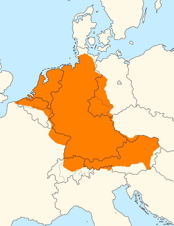
 LoreC10 — Continent Germanic area in 962 vs borders in 1962
Published: 2017-11-07 22:59:47 +0000 UTC; Views: 2185; Favourites: 19; Downloads: 12
Redirect to original
Description
The area in orange is the area covered by continental west germanic dialects (modern day German and Dutch dialects) in around 962, in black the international borders 1000 years later. Thuringia and official linguistic boundaries in Belgium and Switzreland are also present.Related content


Comments: 41

Part of the map is most definitely incorrect. The whole coastline from West Flanders to (around) Étaples used to be Germanic back then. If you draw a curved line from Étaples to Lille, the areas northwest of it would have been Old Dutch. The whole area is full of Dutch toponyms that originate exactly from, or slightly after, that time in the Middle Ages (e.g. Hardelot, Dennebroeucq, Wissant, Audrehem, Nortkerque...).
I also can't believe that the area of the current country of Luxembourg was (for the biggest part) non-Germanic back then. It's also full of Germanic medieval toponyms. It was at least most definitely Germanic two ages later, which can (e.g.) be seen in a toponym like "Audun-le-Tiche" and also a lot of written documents.
I'm not sure about Alsace and how Germanic it used to be back then. Switzerland however, was indeed less Germanic (as you've showed on the map). You're probably correct about Graubünden/Grisons (but I'm not sure). Wallis/Valais with its higher Rhone valley would be colonised by the Walser Germans a century later (in the 11th century), so you're correct about that as well. If I'm right however, a few areas north of Wallis (of Kanton Bern) would have already been Germanic during the 10th century.
I don't want to argue about the Austrian territories (don't know much about the situation back then), but you're probably correct about the linguistic frontier in the east (maybe even a little bit favourable to Germans), judging from the maps I've seen about the Ostsiedlung. The northern frontier is fairly correct. The North Frisian islands were already settled by Frisians back then (which is too difficult to mark on this map), but the North Frisian mainland was not.
👍: 0 ⏩: 0

By the way, would you mind if I want you to draw Italy in 1942 with borders of province and its districts?
👍: 0 ⏩: 1

I’m currently very busy both in life and with many request I have to do, I’ll take your request into account but it will probably take a lot before I do it, sorry
")
👍: 0 ⏩: 1
It's okay. I don't want to force you to do something.
👍: 0 ⏩: 0
In this map I’d like to show only west germanic, maybe in a next one I could do it ^^
👍: 0 ⏩: 1
 (Smile)")

Great work! Hope to see more in the future!!
So, is East German not Continental Germanic Dialect?
👍: 0 ⏩: 1
thank you! More like what?
It’s pretty much a dead branch over all

👍: 0 ⏩: 1
mmh, I have a huge AH linguistic map to come but it will require me more…
👍: 0 ⏩: 1
Take your time, no one is going to rush you since most of the deviantart community knows that rushing artists is not the way to go.
👍: 0 ⏩: 1


That's an interesting map, but I'll have to warning you that the author of the map himself said it's map isn't totally accurate for the borders (see : fr.m.wikipedia.org/wiki/Fichie… ), so I suggest you to hear the remarks of Tonio and Arminius, because some parts of the borders are inaccurates (Nord-Pas-de-Calais linguistic border is totally false by eg) and Tonio know very well linguistical history (especially for Switzerland obviously ^^)
Here is a map for the Nord-Pas-de-Calais : fr.wikipedia.org/wiki/Flamand_…
I know it's said that the border is for the 7th and 8th centuries, but in the 9th the "recul" of Flemish wasn't yet big
Boulogne was still a Saxon speaking area, Calais (under Guines influence) a former Danish colony, Saint-Omer, Roubaix and Tourcoing mainly Flemish.
Another map that could interesting you for Wallonia : www.noviomagus.info/images/taa…
The darker area in Wallonia and Flanders are the bilingual zones, where germanics & romances speakers could be found
I suggest you to use colored dots/points for areas with germanic minorities, but also grey dots/points for the areas with romanics minorities (by eg in the valley of Moselle, from Trèves to Coblence, see : en.wikipedia.org/wiki/Moselle_… )
These dots could also be useful to underline the long cohabitation for centuries between Rhaeto-Romances and Germans colons in medieval Alps, because there was no "strong" and neat linguistic borders in the 9th centuries, the linguistic borders only become cleaner later (with the rise of French language for the western part and the assimilation of nearly all bilinguals areas).
I hope that will help you
👍: 0 ⏩: 1
He says that the political borders are approximate while linguistic borders should be right…I will look into that tomorrow anyway, but I would like to keep the map with any transition area…I’ll se what I can do.
Thank you
👍: 0 ⏩: 1

I went on the page and i'm not sure of what is refering to however he expressly says that he based himself only on direct litterary sources. The original German author of the map seems to have compiled data according to evidence from presence of Germanic scriptae writing monastery which isn't necessarily representative of what you can achieve using other evidences such as toponymy and reconstruction of migration pattern by what is known of later dates (The Walser notably of which i spoke you earlier). A Germanic area could totally have only Latin/Romance scriptae writing Monastery and vice-versa.
👍: 0 ⏩: 1

Oh this is very cool, i love maps about languages and ethnic groups :3
👍: 0 ⏩: 1

Good overview!
Just one thing bugs me, you probably took this basemap:
upload.wikimedia.org/wikipedia…
But I thought the Rhine valley at the alsace became allemannic during the peoples migration era, so in the 10th century
they should already live there. I think the map shows only the political duchy and is not perfectly ethnical.
I read this on Wikipedia (I write a translation below):
Fränkisches Reich 511–925
In der fränkischen Zeit, genauer seit etwa 500, erfolgte eine starke Zuwanderung germanischer Siedler, die die gallorömische Bevölkerung nach und nach überwogen. Auf diese Zeit geht der Name „Elsass“ zurück, dazu oben Näheres. Straßburg, seit 614 Bischofssitz , war neben Basel und Speyer die wichtigste Stadt für die Region.
Frankish Empire 511-925
In the frankish era, exactly since around 500, a strong migration of germanic settlers began, who slowly replaced the rests of the gallo-roman people. The name "Elsass" dates back to this time. Straßburg, since 614 seat of a bishop was beside Basel and Speyer the most important city of the region.
So at least to me it makes no sense that in 962 there were no Allemanics in Elsass, beside even in roman times germanic tribes like the Triboker lived there (tho they might have migrated away or mixed up).
Also I think it was even Scipia who said that the frankish language area was deeper into Wallonia back then, or at least a huge mixed area. But maybe it has already stabilized in the 10th century, you can research that a bit if you want it to be accurate.
The rest seems to be right, tho I´m not sure about the borders for the swiss area as well, as they might have only used the political duchy border as well and not the ethnical.
Ah I just looked up another thing, Südtirol can´t be correct either, because the Bajuwaren started to settle there very early already in the 6th century:
Zwischen dem 6. und 9. Jahrhundert wurde das Gebiet von den Bajuwaren besiedelt, die dort auf die Langobarden und die romanisierten Ureinwohner stießen.
Between the 6th and 9th century the area has been colonized by Bajuwaren, who met Langobardians and romanized natives there. I also heard the Bajuwaren mixed partly with the rest of the Goths.
This is not meant to be any german wanking, just to share what I know and so you have a perfect map. I hope this helped you.
👍: 0 ⏩: 1
I'm not sure that they used the administrative borders of political entities because actually here it shows that the Duchy of Swabia actually covers today southern Alsace as well, so the norm would require that all the area was coloured. I will look into that to clarify it. And in fact this applies to other parts as well.
In Belgium there was indeed a transition area though the map doesn't have transition in the key, said this, I think they made an average there.
Well, Switzerland doesn't surprise me, after all Bern stayed romance speaking for long and Romansch speaking people reached as far north as the Lake of Constance. It might be true that in the 10th century they had already backed a bit thought.
In Alto Adige the german infection had indeed already begun but in 962 only some zones in the real north were completely germanized the rest were mainly Ladin speaking, in fact Val Venosta, which is on the opposite side of Alto Adige compared to coloured areas of the map, will stay romance until 18-19 century and some areas in the region are still Ladin.
Fine, did we complete the Germanic-romance border now?
Ah no, there is Carinthia left...well, that was Slavic but I was very surprised to see how it was strongly Slovenian still in 962!
 (Wink)")
👍: 0 ⏩: 2
I seriously doubt Bern was still romance by the 10th century. I wonder where are your sources for that, cause most sources I know say that the Sarine-Aar line was established by the 9th century. I also heard Germanic went a bit further west for a while up Today's Vaudois Aigle Region and was re-latinized afterwards.
Also from the French Wikipedia Article about the history of Wallis, upper Walis started to germanized from the 7th century. In the 10th century the border was just a little upper the Rhone Valley. The Germanic established there from Oberland meaning that at least this region was Germanic before.
fr.wikipedia.org/wiki/Histoire…
en.wikipedia.org/wiki/Walser
As much as Arminius, i seriously doubt that Alsace wasn't Germanic by that time. Especially Sundgau since the Germanic "Mulhausen" was already established.
On the other hand, it's indeed been a bit restrictive for Romansch. By the 10th century Today's southern St-Gall canton, Southern Voralberg and Liechtenstein were still Romansch.
Also, the map should be called "Continental West Germanic in 962" since it excludes Nordic Germanic speaking areas in Danemark.
Also from where did you got the source for this map?
👍: 0 ⏩: 1
Here: upload.wikimedia.org/wikipedia…
But it’s arguable probably…
I knew someone would say it. Continental here means Dutch and German in opposition to insular English and Scandinavia (peninsular).
And that name wouldn’t fit in DA title anyway…
👍: 0 ⏩: 1
Ah ok, i understood it as all Continental European area.
👍: 0 ⏩: 1
Well the german "infection" had to fight the romanic cancer
It´s no suprise actually, the Rhein area and France had a high birth rate, also Italy btw.
while the rest of Europe especially the east and the mountain valleys were very sparsely populated.
Before Romans came Northern Italy was celtic.
👍: 0 ⏩: 1
Pff, I doubt it can.
Yes, and it stayed like this for the rest of the time until our days ^^
But my surprise was seeing how fast the germanization of Carinthia was!
Yeah, guess what has been the same for hundreds of thousands of years? Yep, precisely: the Alps!
(again? yes, again. Always until you will convince yourself.)
👍: 0 ⏩: 1
I have no idea how many people lived in Carinthia back then. I read the Danube colonization by the Bavarians was also fast, every generation some more kilometers. There was no resistance until they hit the Hungaryans.
Guess what is not the same for thousands of years, yes right where people move and live
and have the right to be
👍: 0 ⏩: 1
It’s interesting! It’s almost like Europe was a new continent at the time even thought romans had already been there for long!
That’s exactly why Alps are a good border. Because they don’t move and, most importantly, they can’t be moved.
👍: 0 ⏩: 1
Yes but nations form around people and where they live not around water or hills necessarily.
So if you want your perfect geographical nations you have to expell or kill those people,
because there is always the risk that those people want to be part of the nation of their people
and not of your geographical nation. Following your logic. Sorry we will never agree here XD
👍: 0 ⏩: 1
of course not, I don’t have to at all, that’s exactly the opposite! Nation exist sure, but nations are different compared to countries, countries must follow geographical borders, nations don’t.
👍: 0 ⏩: 0
