HOME | DD
 plexust — Map of the Atregonese Aigentarate
Published: 2013-07-31 10:45:36 +0000 UTC; Views: 6661; Favourites: 73; Downloads: 140
Redirect to original
Description
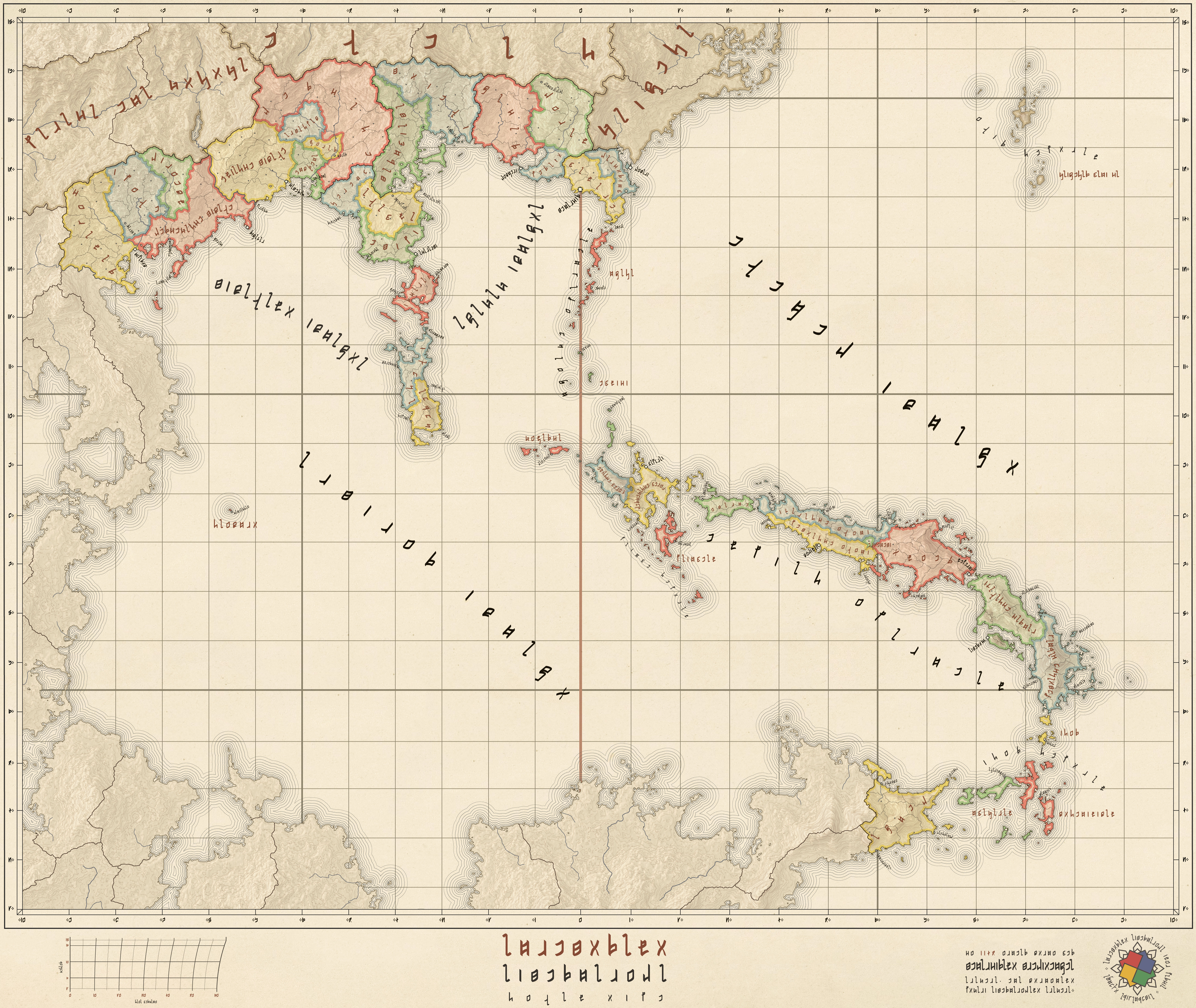
This map is for the World of Gotha ( worldofgotha.com/ ), a collaborative geofiction project set in a pseudo-Victorian setting. Atregona is my nation, which is a sprawling, corrupt oligarchy. Most of the nations in the world appropriate foreign languages for use within their nations, and the national language of Atregona is Basque. The script featured on the map, however, is a constructed script.Prepared in Illustrator, Photoshop and FontLab Studio.
---
A map of the Atregonese Aigentarate and the surrounding areas. Atregona is a country in southern and central Anaria. It consists of 306 banners, and has a total landmass of 441,262 square kilometers, separated by the Argiron Sea into two similarly sized regions, mainland Atregona, and the Eccasian Archipelagio. Land borders are shared with Istania and Errea, among others.
Atregonia is ruled by the Aigentar, selected through male-preference cognatic primogeniture, wherein a female may only attain the title if she has no surviving brothers. Historically, the Aigentar was a supreme ruler of Atregonia, forming a central government advised by the High Advisor (Goitanune), and the Central Council (Sinetsiak). A specialized system of hierarchy of civil (Arrezko), religious (Urdinzko), commercial (Horrizko), and military (Gorrizko) administrative bodies developed over the years to accommodate the sprawling empire. The groups of government eventually developed an organic separation of powers, with higher executive, and military powers being conferred to the military government, civil affairs being conferred to civilian government, judicial and religious affairs to the religious, and maritime and commercial powers to the commercial.
A diverse range of cultures exist in Atregonia, resulting from the blending of various elements of Tragoni, Meyistri, Ilistan, and Northern Anarian cultures, the majority culture is primarily Sadarine and Tragoni. Atregonian culture has been influenced by the cultures of neighbouring countries. This is manifested in its language, cuisine, music, dance and theatre. The arts, particularly literature, have historically been influenced by the local form of Sadarisnism. In a traditional village, the temple is the center of cultural life, with various altars and shrines to various Sadarine deities a common sight throughout the nation.
Related content


Comments: 7

 (Wink)")

Thanks, I appreciate the compliment!
👍: 0 ⏩: 0

Beautiful map, and I am amazed by the detail and background information you put into it. Where did you find the constructed script?
👍: 0 ⏩: 1
Thanks! I created the constructed script in Illustrator CS6 and FontLab Studio 5.
Here is a chart of the letters: i.imgur.com/JYEPVyU.png
👍: 0 ⏩: 1
Thank you kindly for the link
👍: 0 ⏩: 0

I love the colors and how it is very sober. Not very keen on the font, but overall a IMO an interisting map! How did you make those mountains and levels? Did you draw then all by yourself?
👍: 0 ⏩: 1
The font is my first attempt at creating a typeset-look artificial script, so there may still be some bugs to work out; I know it's not perfect. The contours were derived from fractal terrains height data and vectorized with Illustrator's LiveTrace.
👍: 0 ⏩: 0