HOME | DD
 Ponentguy — Biomes, ocean currents and prevailing winds map
#map #ocean #wind #binomes #cartography #climate #planet #climatemap
Published: 2021-03-22 20:38:23 +0000 UTC; Views: 3071; Favourites: 29; Downloads: 1
Redirect to original
Description
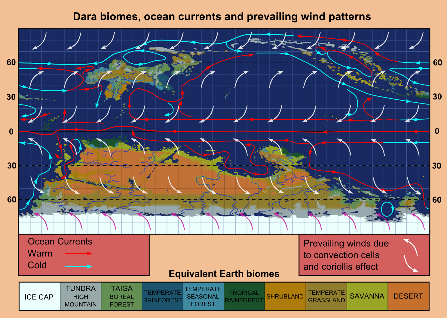
This map represents the climate in my conworld (from now on called Dara). Most of my drawings are set here.These two older maps give different perspectives of this world.
Map 1
Map 2
Planet and thermal systems
Dara is a highly habitable planet, slightly smaller and with a thicker atmosphere than Earth, orbiting a slightly colder star than our sun. It has an axial tilt of 14º, which makes seasons less intense, but would also make latitudinal thermal variation more extreme if it wasn't for the thicker atmosphere providing more thermal regulation. The equatorial ocean surface current runs almost freely, which makes it remarkably intense. This hot water current drives large gyres that help equalize the planet's temperature. There is a large ice sheet starting around 75º south, but no permanent ice in the northern pole.
Deep ocean currents are relatively weak, which makes the deep ocean hypoxic. This also reduces upwelling, reducing nutrient availability.
Geography
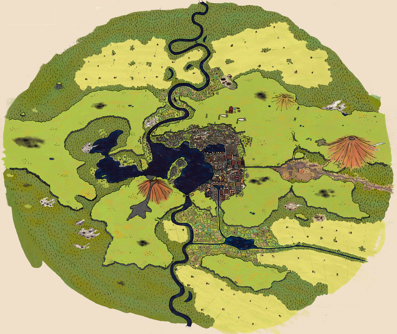
The Southern megacontinent (Panmeridia)
Life there is focused around the coasts, as the inland climate is extreme, ranging from scorching hot to bone chilling cold. It is usually dry, until the storm season arrives.
Still though, there are many places inland where live prospers. These are composed mainly of the great rivers, lakes and bogs that have large enough masses of water to generate a more pleasant microclimate. There is also plenty of groundwater that allows some inland settlements.
The South Pole is occupied by an ice sheet, surrounded by a ring of lakes, from which radiate a series of extremely long, wide and slow rivers. These are The Glacial Rivers. They are the highways of the continent, and most of the cities inland are near them. Using the rivers and the Glacial Lake Ring, or southern nexus, ships can cross the continent without sailing the sea. (This map illustrates it better)
South is populated by a wild variety of peoples: Large expansive empires, kingdoms and federations, city-states, desert and steppe nomads and jungle tribes. To this mixup we have to add the presence of northern colonists, merchants and conquerors, who will forever change the dynamics of this land.
The Northern continent (Azoria)
With a temperate and generally humid climate, this continent has nicer living conditions. An interrupted industrialization due to the lack of resources, overpopulation, wars, epidemics and crop failures convinced the people and leaders of multiple Azorian nations of the necessity of expansion and colonization of new lands, aided by their newly achieved technological edge.
The Isles
It’s a huge volcanic archipelago ranging from tropical to arctic climates. Cultures also vary greatly between islands, from extremely violent to more or less peaceful.
How it was made
I used Space Calc on a height map of the planet with different parameters, then I combined multiple output maps until I got something which looked more or less like what I liked. Then I sprinkled some extra humidity around places where monsoons should occur.
Afterwards I added an Earth-like three cell atmospheric convection model and used some speculation and correlation to guess the surface ocean currents and changed the biomes accordingly.
Related content


Comments: 14

👍: 0 ⏩: 1

👍: 0 ⏩: 0

👍: 1 ⏩: 1

👍: 0 ⏩: 1

👍: 0 ⏩: 1
👍: 1 ⏩: 1
👍: 1 ⏩: 0

👍: 0 ⏩: 1