HOME | DD
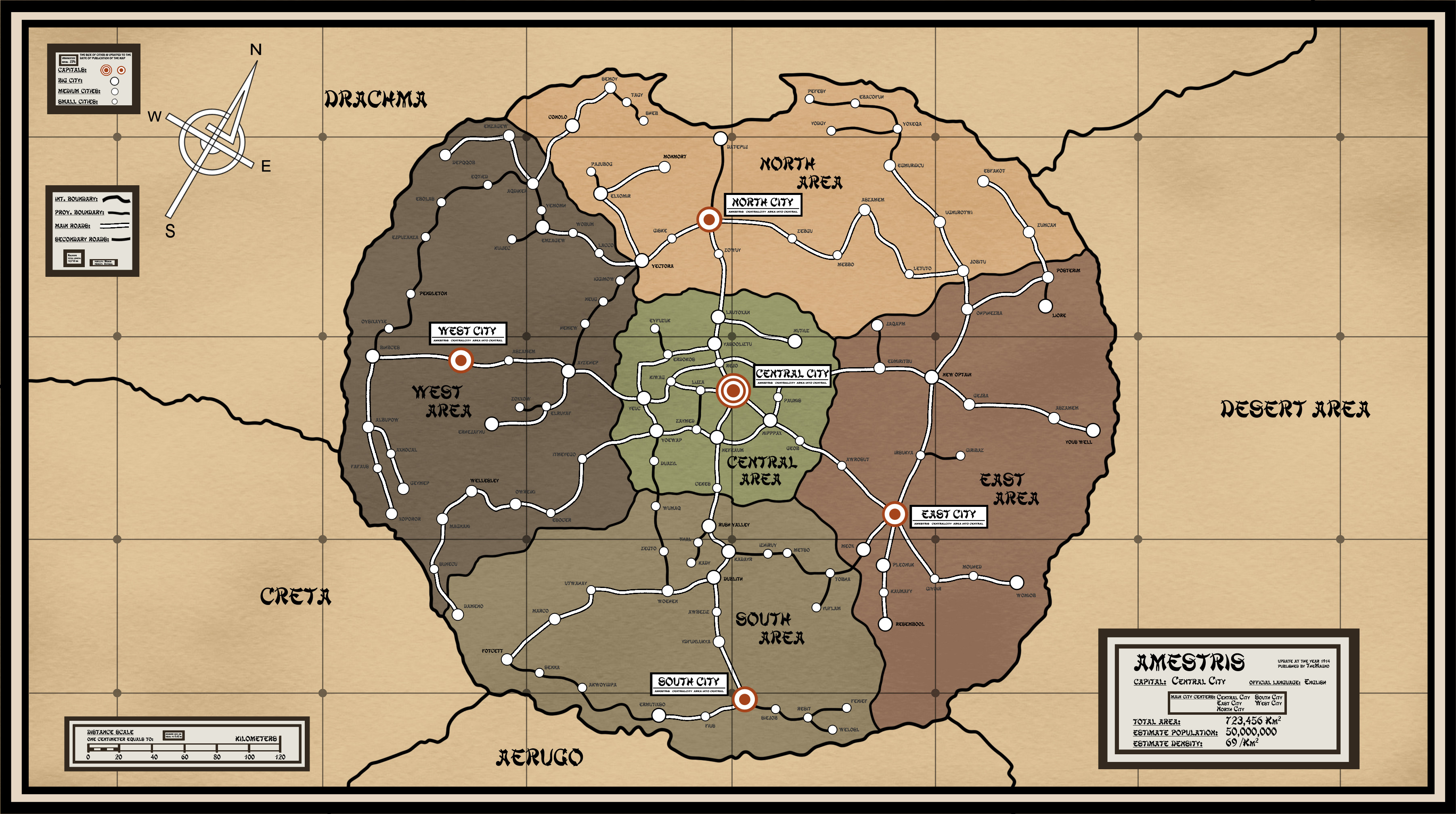
 PosterMasterChef — Final Amestris Road Map

Published: 2012-12-06 15:42:30 +0000 UTC; Views: 14910; Favourites: 181; Downloads: 0
Redirect to original
Description
 WARNING! NOT ALL DATA IN THE MAP ARE CORRECTED, FIRST READ BELOW
This is the final version of Amestris road map, updated with new names.
As with the first two I took pictures from the episodes: 32, 35, 43, 5 and I joined various information.
I added more city names that I found throughout the anime (episodes 10, 35).
To view images from which I drew the map you can see "Images for New Amestris Road Map" postermasterchef.deviantart.co…
DESCRIPTION OF INFORMATION IN THE MAP:
Below is a complete list of city names included and their origin (some city names or their positions I've put forward by the images of Ep .35 and 10)
CENTRAL AREA
 Central City____ObviousNapoli________(new)from images of the map of Ep. 10
NORTH AREA
Ballyhill_______(new)from images of the map of Ep. 10Cate Movil_____(new)from images of the map of Ep. 10 Conolo_______(maybe)inferred from images of the map of Ep. 35Empalme______(new)from images of the map of Ep. 10Fisk__________from the transmutation circle of Ep. 35Ganqak_______(new)from images of the map of Ep. 10Monmort______(maybe)inferred from images of the map of Ep. 35North City_____ObviousOrent________(new)from images of the map of Ep. 10Vectora_______(maybe)inferred from images of the map of Ep. 35Yoltica________(new)from images of the map of Ep. 10
SOUTH AREA
Dublith________from the map of mangaFotcett________from the transmutation circle of Ep. 35Instmart______(new)from images of the map of Ep. 10Monet________(new)from images of the map of Ep. 10Rush Valley____from the map of mangaSatlort________(new)from images of the map of Ep. 10South City_____Obvious (even from the circle of transmutation of Ep. 35)South Dalt_____(new)from images of the map of Ep. 10WEST AREA
Pendleton_____from the transmutation circle of Ep. 35Riviere________from the transmutation circle of Ep. 35Wellesley______from the transmutation circle of Ep. 35West City______ObviousEAST AREA
Cameron______from the transmutation circle of Ep. 35East City______ObviousEast Motel_____(new)from images of the map of Ep. 10Elsto_________(new)from images of the map of Ep. 35Ilsici__________(new)from images of the map of Ep. 35Ishval_________from the transmutation circle of Ep. 35Liore__________from the circle of transmutation of Ep. 35 and from the map of manga (which is called Reole, however I kept the name of the cartoon)New Optain____from the map of mangaPosterim______(maybe)inferred from images of the map of Ep. 35Resembool_____from the map of mangaVanes Balt_____(new)from images of the map of Ep. 35Yous Well______from the map of manga ALL OTHER NAMES OF THE CITIES ARE INVENTED, for distinguish from the correct names are written in dark gray rather than black.
NAMES THAT I HAVEN'T INCLUDED
Briggs________from the transmutation circle of Ep. 35Easthert______(maybe)inferred from images of the map of Ep. 35Farybert______(maybe)inferred from images of the map of Ep. 35OTHER INFORMATION
In the boxes on the sides of the map I have included some information that I knew, others I have assumed:
By suggesting of I rearranged the distance scale. It's based on size of lunar shadow during the eclipse: taking into account that the shadow has a diameter of 268 km and follows the shape of the transmutation cirlce for the Stone, I approximate the shape of the country with an ellipse of 310x282 km, with an area of 68,625 Km ^ 2 By suggesting of I've changed all unpronounceable or absurd city names with similar ones, but real, taken from Europe maps. By suggesting of I've eliminated the road connection between Yeres and Yoerem in the Central Area. not a single map shows it, I don't why I've put it... thanks to , I've fixed the name of Aszamem in the West Area, because was identical to a city in East Area (both are cities with invented names, so no prob) I calculated population density knowing that the inhabitants are about 50 million. I assumed that the country's official language is English (all is written in that language). I've included some dotted lines (seen in the images of the anime) that I think are sub-regional boundaries, there are also two dotted lines through the entire map that start from the south of South City, I honestly have no idea what they can be...If you notice errors or discrepancies please inform me, pointing to the episode where I can find the correct information, and if you give me the name of a city, please tell me the fake name I've put in the map.
THANK YOU ALL FOR WATCHING AND FOR ANY HELP!!
Related content


Comments: 56

Hmm it's a tricky one! I wonder if Arakawa actually measured her country of Amestris in terms of the size of the moon's shadow? Maybe she didn't...
 (Smile)")
👍: 0 ⏩: 0

I don't want to seen rude, but can I ask why you didn't include Briggs, Eastherst, and Farybert on the map?
👍: 0 ⏩: 1

Well, Farybert and EastHert are very small villages, near Riviere and Liore, I've seen them in the map of episode 35 [link] , but are too small to insert in the map. Briggs is a fortress, not a city, so i can't put it in the map.
I've mentioned in the description because someone may be use them as place of origin of his character

👍: 0 ⏩: 0
Thank you, this is awesome! ^_^
👍: 0 ⏩: 1

<= Prev |