HOME | DD
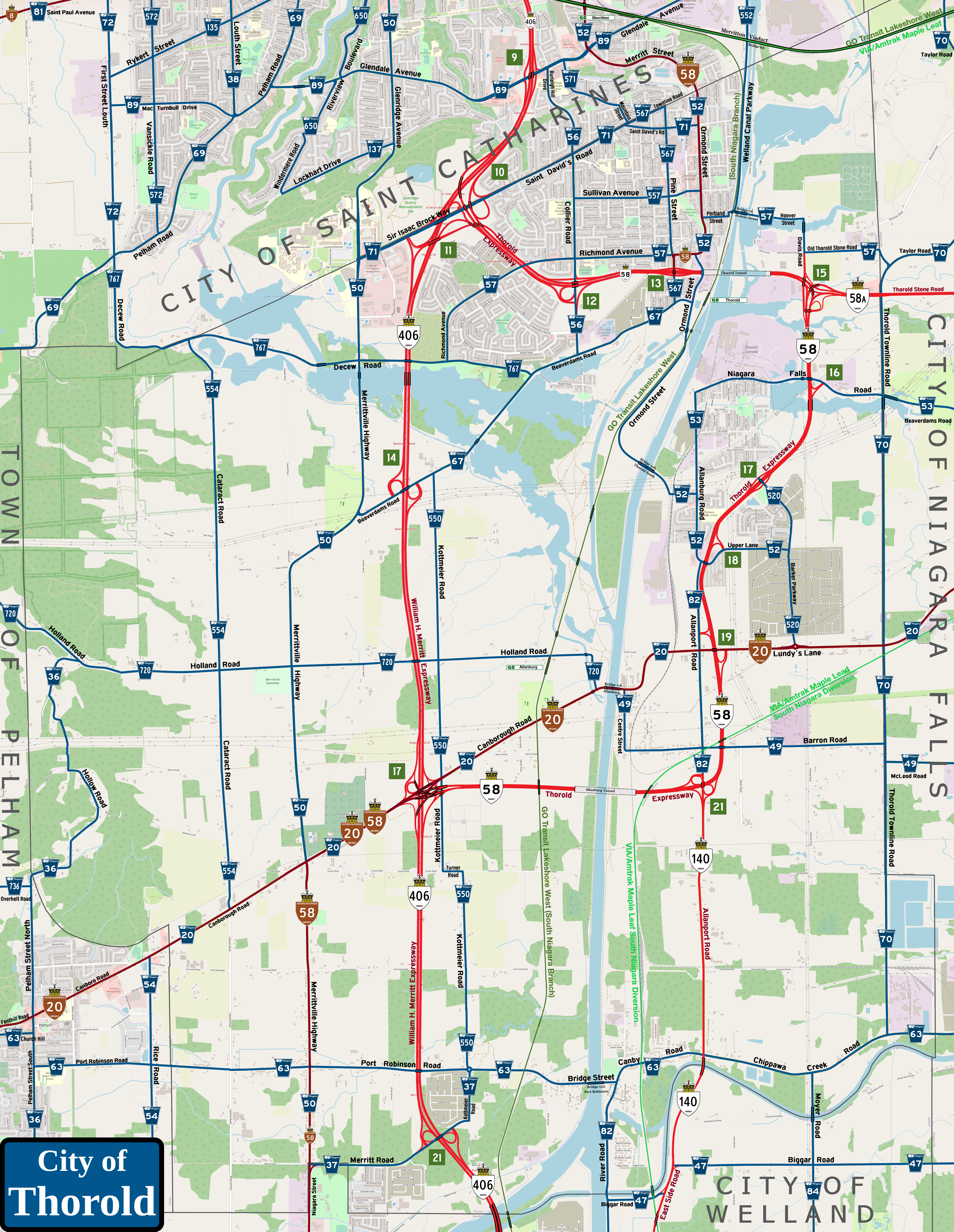
 Pyeknu — Port Colborne (fantasy map)

#niagara #ontario #go_transit #port_colborne #fantasy_map
Published: 2022-11-15 01:11:55 +0000 UTC; Views: 783; Favourites: 1; Downloads: 0
Redirect to original
Description
With the map of Fort Erie I just did recently as a sort of proof of concept, I decided to tackle my recent home town of Port Colborne for my next subject.As I did with the Fort Erie map, I worked in improvements in the transportation network (both road and rail) to reflect an expanded version of both that I foresee happening in the next century or so.
Among said changes are as follows:
1) This map shows the part of the expanded Highway 406 (William H. Merritt Expressway) that follows the border between Port Colborne and Niagara Falls until it reaches the southeast part of Welland, where it shifts onto the old right-of-way of the long-defunct Michigan Central Railway mainline passing under Miller Road at the top centre of the map. From here, the expressway will cross the ROW of Highway 140 (which I give the name East Side Road to parallel West Side Road/Highway 58 on the opposite side of the Welland Canal) to turn north parallel to the Welland Bypass channel until reaching East Main Street before hopping over the canal in a skyway and connecting to the existing roadway. This will be covered more in a map of Welland I might do in the near future.
2) To serve as a sort of through link between Highway 406/the Queen Elizabeth Way and the Highway 3 corridor west of Niagara, I'd revise Highway 3A (the original version having been downloaded in 1970) that would use the old CNR Cayuga Subdivision/Canada Air Line Railway ROW into the southwest part of Welland before hooking into the current Highway 58A (Townline Tunnel Road) to eventually lead into the 406 at Miller Road/Doans Ridge Road/Netherby Road. This would see 58A renumbered to 3A and the old route of Niagara Route 525 uploaded to the province; in preparation for the upcoming Welland Intermodal Terminal on the Bypass channel, Route 525 would be shifted north onto Netherby Road between Rusholme Road and Miller Road. Of course, allowing truck traffic to get into the WIT from Highway 406 northbound (here westbound) requires that Route 525 be linked directly to the expressway at Exit 32.
3) Because of recent issues concerning the old Bridge 18 (Forks Road) crossing the old Welland Canal at Dain City in the south end of Welland, that whole part of the Rose City was effectively cut off from the rest of the peninsula save for the link on Canal Bank Street; the old bridge just rusted out and was removed pending replacement in the next few years. I would change that to have two northerly exits from Dain City, through both Canal Bank Street and a reopened West Canal Road between Forks Road and Humberstone Road; this would be part of a relocated Niagara Route 33. In addition, I'd have two twin-leaf Chicago-type bascule bridges at the levels of Forks Road and Haun Road/Humberstone Concession 3 that will permit easy access to the east and south from Dain City.
4) Naturally, GO Transit service would be extended to Port Colborne, using the city owned railway from Yager Road branching off the CNR Stamford Subdivision paralleling the east bank of the Welland Canal into the city itself. The main line of the South Niagara Branch would use (as mentioned before) the Trillium Raiwaly Canal Division line (the old Welland Railway) from Saint Catharines south to Welland, where it would loop onto the CPR Hamilton Subdivision to pass through the Townline Tunnel and connect to the Stamford Subdivision onward to Stevensville and Fort Erie. Once passing under Miller Road, the service would branch off on two spurs, one heading northeast to Niagara Falls (the Fallsview Spur) and the other looping south and back towards Port Colborne (the Port Colborne Spur). The city would get three GO Transit stops in Port Colborne itself off Durham Street near the old INCO factory works, at Yager east of Highway 140 to serve the rural northern part of the city and at Doans Ridge off Miller Road (which serves as a transfer point to the Fallsview Sub or the mainline South Niagara Branch.
5) There would be no stop in Port Colborne for the re-routed VIA/Amtrak Maple Leaf service; the nearest stop will be in Welland east of the Main Street Tunnel.
With that, here's the updated list of regional roads in the Canal City...
Sherkston Road (Niagara Route 1): Upload to the region as part of a more direct route to Ridgeway and Crystal Beach in Fort Erie from Main Street East;
Main Street (Niagara Route 3): No changes to this route save for the expansion of provincial designation for the part from the Wainfleet township limits to West Side Road. The route remaining in the region would also be signed as Historic Highway 3 to provide a sort of connecting link between the two parts of Highway 3 in the Canal City;
Mellanby Avenue/Welland Street (Niagara Route 3A): No changes to this route, though it would also be signed as part of Historic Highway 3 due to the fact that Bridge 19A serves as a southern bypass to Bridge 19 at the north end of Lock 8 whenever ship traffic is moving through the Welland Canal;
Killaly Street (Niagara Route 5): The eastern stretch of the route from Welland Street to Main Street East is uploaded back to the region;
Forks Road/Fox Road (Niagara Route 23): With the construction of Bridge 17A over the Welland By-Pass channel and the replacement of the old Bridge 18 over the Welland Recreational Waterway, Route 23 can be expanded eastward from West Side Road, thus forming a mid-south connector route through Wainfleet, Welland, Port Colborne and Fort Erie. The part of Route 98 on Forks Road would be re-designated as Route 23, of course;
West Side Road (Niagara Route 54): Re-uploaded back to the region, but renumbered from Route 64 to provide continuity with the main part of Route 54 in Welland and Pelham;
Steele Street (Niagara Route 64): Re-upload back to the region with the original part south of Killaly Street and upload the part north of Killaly Street to Main Street West to the region;
King Street/Sugarloaf Street (Niagara Route 66): Re-upload back to the region with the original part east of Steele Street and upload the part west to Rosemount Avenue to the region;
Kingsway/Haun Road/Bethel Road (Niagara Route 68): With the construction of Bridge 18A over the Welland By-Pass to serve as a southern link for Dain City in Welland, Humberstone Concession 3 Road can be uploaded to the region out east to Miller Road. The part west of East Side Road would be renamed Haun Road (in conjunction with the road spur in the southern tip of Welland) while the part east of East Side Road is renamed Bethel Road in salute to the hamlet said route passes just north of;
Cement Road/Clarence Street/Welland Street/Chippawa Road (Niagara Route 78): Upload/re-upload to the region (the parts on Clarence Street from Steele Street east and Welland Street to Mellanby Drive were once part of a separated section of Route 68), recycling an old number which covered a spur of old Route 68 just north and east of Lock 8 on the canal; this would serve as the main downtown east-west corridor as well as connecting to the hamlet of Bethel via Chippawa Road;
Elm Street (Niagara Route 80): Re-upload the whole of the route back to the region;
Miller Road (Niagara Route 84): Save for re-uploading the section of route between Main Street East and Killaly Street East back to the region, no changes are planned for this route;
Schill Road/Wilhelm Road/Empire Road (Niagara Route 98): Save for the re-numbering of the section of Forks Road East to Route 23, the only changes to this route are to re-upload the section of Empire Road to the region down to Beach Road, then upload the last part to the entrance of the village of Sherkston Shores at the traffic circle with Elcan Highway;
Rosemount Avenue/Lakeshore Road (Niagara Route 530): Upload to the region as a connected spur to Route 30 in Wainfleet;
Beach Road/Pleasant Beach Road/Michener Road (Niagara Route 801): Re-cycling a route number from the original 1969 regional road grid, but using the old path of Route 1 from the junction of Michener Road and Sherkston Road westwards instead. This would serve as a connected spur of Route 1, plus a direct regional route between Sherkston Shores and the lakeside villages of Fort Erie such as Point Abino, Crystal Beach and Ridgeway; and
Brookfield Road (Niagara Route 802): Re-upload back to the region; this was one of the original regional routes planned in 1969, though such was downloaded to the city of Port Colborne shortly afterwards.