HOME | DD
 Pyeknu — Thorold (Fantasy Map)
#fantasymap #niagara #ontario #thorold #welland_canal
Published: 2022-12-17 16:47:13 +0000 UTC; Views: 568; Favourites: 0; Downloads: 0
Redirect to original
Description
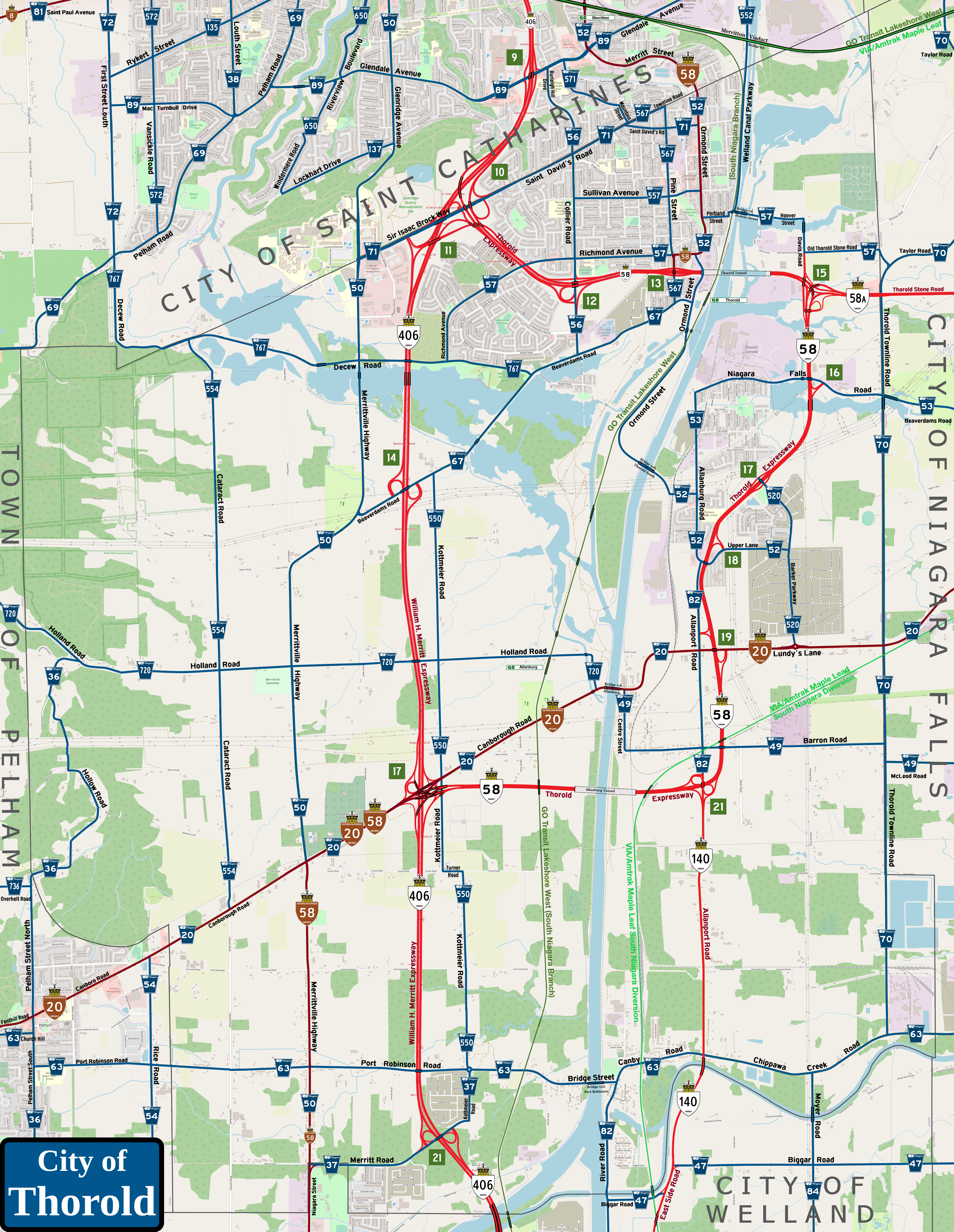
And now comes my fantasy map of the regional seat for Niagara, the home of the famous Twin Flight Locks, the city of Thorold.You'll note a lot of highways are active here. Here are the changes I propose...
The big change is the northern wing of Highway 58/the Thorold Expressway. With the implementation of the new Thorold Intermodal Terminal (run by the Hamilton-Oshawa Port Authority, being developed now by Bioveld Canada) on the industrial lands east of the Welland Canal and north of Niagara Falls Road, it made sense to me to make this part of Highway 58 a full urban freeway from interchange #10 on Highway 406 on the border with Saint Catharines down to interchange #17 by Canborough Road just to the southwest of the hamlet of Allanburg. The improvements put in are as follows:
1) With Thorold Stone Road now uploaded to the province as a relocated Highway 58A from Davis Road to the Queen Elizabeth Way in Niagara Falls, a semi-directional T-interchange is implemented. Due to Highway 58 coming in from the west under the Welland Canal via the Thorold Tunnel, it would form the bottom of a three-level stack interchange, with connecting flyovers overhead. In addition, the part of Davis Road south of Old Thorold Stone Road would be uploaded to the province as a relocated Highway 7186 (currently the section of Thorold Stone Road from Davis Road to Thorold Townline Road) to permit access from the north to the grounds of the Intermodal Terminal. As seen here, freight traffic from the south will have a direct entrance to the grounds of the Terminal. Freight traffic coming in from the east can exit onto Davis Road directly. From the west via Highway 58, it would have to be a roundabout route (due to lack of space) via Thorold Stone Road, Taylor Road and Old Thorold Stone Road to get onto Davis Road to connect to the Terminal grounds; exiting said grounds in this area would have to do such a route in reverse;
2) Heading south, Highway 58 will be bridged over by Niagara Falls Road, with a partial interchange here (again due to lack of space) with northbound exit and entrance on the east side of the expressway;
3) Crossing Beaverdams Creek, the expressway meets Barker Parkway in a simple diamond interchange;
4) At the area of the junction with Allanburg Road and Upper's Lane (misspelled as "Upper Lane" on the map, my mistake), the expressway will twist slightly east to circle around Black Horse Corners without taking away much land on the west side of the Niagara Detention Centre grounds. Due to the sheer development of the area, a simple northbound exit/entrance partial interchange happens here;
5) With the rest of the old highway route now signed as part of Allanport Road, the expressway passes under Lundy's Lane, with a southbound exit/entrance connection via Allanport Road and the northbound exit/entrance directly onto Lundy's Lane, leaving the area directly around Black Horse Corners relatively untouched;
6) The expressway will pass under the CNR Stamford Subdivision and Barron Road, then turn west a third of the way south towards the Turner Road line, with a five-ramp parclo interchange with Allanport Road (more on this below); and
7) A new tunnel under the canal is built to allow the expressway to meet up with Highway 406, some lines merging into Canborough Road at interchange #17, thus creating a partial directional T-interchange with three-stack flyovers.
Because of this design, the Historic Highway 58 markers would be set up to connect the southern end of the Thorold Expressway via Canborough Road directly to Merrittville Highway before heading south on said road into Welland proper. This was the route of Highway 58 when it was commissioned in the late 1930s. I know that after Highway 406 was extended south of Beaverdams Road to end at Merritt Road at Niagara Street/Merrittville Parkway, Highway 58 was made concurrent to the new expressway (then a two-lane road) for simplicity's sake, but I would follow the 1970-era pattern here.
Also, I've added exit numbers for the Thorold Expressway, numbering them concurrent to Highway 406's exit numbers starting from the northern terminus of Highway 58 (exit #10 on Highway 406); this marks the Thorold Expressway as a major spur route to the William H. Merritt Expressway.
In addition, as shown on the Welland map, Highway 140/East Side Road is extended north of East Main Street to eventually cross the Welland River just east of the hamlet of Port Robinson, merging onto Allanport Road for its final few kilometres to connect to Highway 58.
Save for the reconstruction of interchange #17 to accommodate the Thorold Expressway extension, there is no change planned for Highway 406/William H. Merritt Expressway within the boundaries of Thorold.
And now the regional road grid...
Lundy's Lane/Canborough Road/Canboro Road/Fonthill Road (Niagara Route 20): No change here save for the modifications at interchange #17 with Highway 406 as noted above. In addition, the crossing over the Welland Canal at Allanburg will remain, though the bridge will be replaced with a dual-leaf bascule bridge to act as a more immediate alternate route than the Allanburg Tunnel carrying Highway 58 under the canal. Note, as I warned on the Pelham map, the change of spelling for Canborough/Canboro Road once the border is passed; Thorold uses the more classic spelling with the silent "-ugh" ending to the name while Pelham does not. The whole road will be signed as Historic Highway 20 throughout, with Historic Highway 58 signs added from Merrittville Highway to Highway 406 as noted above;
Pelham Street/Hollow Road (Niagara Route 36): As shown in the Pelham map, Route 36 is re-uploaded to the region north of Woodlawn Avenue all the way to Canboro Road in downtown Fonthill, then extended along Pelham Street North and Hollow Road to end at Holland Road;
Merritt Road/Kottmeier Road (Niagara Route 37): No changes to the route as it exists now, but it would be extended past interchange #21 on Highway 406 east to Kottmeier Road, then turn north to end at the roundabout with Port Robinson Road;
Centre Street/Barron Road/McLeod Road (Niagara Route 49): Atop extending Route 49 west along McLeod Road from Montrose Road in Niagara Falls to Thorold Townline Road, a western extension will be made along Barron Road to Centre Street in Allanburg, then turn north on said street to end at Lundy's Lane by the eastern landing of Bridge 11A;
Niagara Street/Merrittville Highway/Glenridge Avenue (Niagara Route 50): No change here save for the signing of Historic Highway 58 north to Canborough Road;
Merritt Street/Ormond Road/Hayes Road/Upper's Lane (Niagara Route 52): The route would be re-uploaded to the region to Richmond Avenue, then head south on Ormond Street to Beaverdams Road. Here, a new extension would be built parallel with the Trillum Railway Canal Line to the old connecting point with the CNR Thorold Subdivision, which crossed the Welland Canal at the long-dismantled Bridge 10. A new Bridge 10A would carry Ormond Street across the canal, allowing an alternate western access to the neighbourhood of Thorold South and the Intermodal Terminal; again, this would be a dual-leaf bascule span to remove potential overhead obstructions to passing ships. Once across the canal, the route will connect to Hayes Road (not marked here) before heading east to Allanburg Road before turning south. Route 52 would be signed on Allanburg Road to the interchange with Highway 58, then cross over and follow Upper's Lane (again, apologies for the misspelling) to end at Barker Parkway. Note that the part of this route north of Richmond Avenue will be marked as Historic Highway 58; before the Thorold Expressway and Thorold Tunnel were built, said highway came up from Allanburg on Allanburg Road, crossing the Welland Canal on Bridge #9 by the Thorold Intermodal Terminal grounds, then headed north on Ormond Street into Saint Catharines;
Beaverdams Road/Niagara Falls Road/Allanburg Road (Niagara Route 53): Re-uploaded to the region all the way west from Niagara Falls along Beaverdams Road and Niagara Falls Road (once past the border into Thorold) to end at Allanburg Road. However, in lieu of signing the section of Allanburg Road down to Hayes Road as Route 553 as was done before, the Route 53 designation would be carried down;
Rice Road (Niagara Route 54): No changes planned here;
Burleigh Hill Drive/Collier Road (Niagara Route 56): No changes planned here;
Old Thorold Stone Road/Davis Road/Hoover Street/Chapel Street South/Portland Street/Richmond Avenue (Niagara Route 57): To act as a northern alternate route over the Welland Canal to the Thorold Tunnel, a new Bridge 7A (a single-leaf bascule span) will be built at the southern end of Lock 7 to reconnect Hoover Street to the city street grid. Thus, the central wing of Route 57 will be established from Taylor Road west along Old Thorold Stone Road to Davis Road, turn north on the latter to Hoover Road, then head west on that road across the canal before turning briefly south on Chapel Street before going west on Portland Street to end at Ormond Street. The separate western wing to Route 57 will take up all of Richmond Avenue from Ormond Street west to Decew Road. The part of Richmond Avenue from Park Street to Ormond Street will be marked as Historic Highway 58; the old route through downtown Thorold was maintained by the province until the early 1970s even with the Thorold Expressway completed to Highway 406;
Church Hill/Port Robinson Road/Bridge Street/Canby Street/Chippawa Creek Road (Niagara Route 63): The whole route is re-uploaded to the region from Victoria Avenue on the border between West Lincoln and Pelham east to Allanport Road. A new Bridge 12A (dual-leaf bascule span) will reconnect the road at Bridge Street to reunite the two sides of the hamlet of Port Robinson;
Beaverdams Road (Niagara Route 67): In lieu of turning north at Park Street to connect at Highway 58 (see below), Route 67 will head east to connect to Ormond Road;
Pelham Road (Niagara Route 69): No changes planed within Thorold; the extension beyond Glendale Avenue shown here will be explained in the map for Saint Catharines coming soon;
Thorold Townline Road/Taylor Road (Niagara Route 70): No changes planned here;
Sir Isaac Brock Way/Saint Daivd's Road (Niagara Route 71): No changes are planned for the current route as signed now to Collier Road, but the length of Saint David's Road east to Ormond Street will be re-uploaded to the region;
Allanport Road/River Road/East Canal Road (Niagara Route 82): With the uploading of the section of Allanport Road south of Barron Road to the province as the northern end of Highway 140, Route 82 was re-located to River Road in Port Robinson, serving as a southern connector between the hamlet and the new industrial areas of Welland all the way down to Lincoln Street as shown in the map of the Rose City. However, a northern wing of Route 82 will remain, connecting the northern end of Highway 140 with Allanburg Road north of Lundy's Lane;
Moyer Road (Niagara Route 84): No changes planned here;
Barker Parkway (Niagara Route 520): A new spur line of Route 20 connecting Lundy's Lane through the new neighbourhood being raised south of Highway 58, ending at the diamond interchange with the Thorold Expressway as described above;
Kottmeier Road (Niagara Route 550): A new unconnected spur line of Route 50 that follows Kottmeier Road from Port Robinson Road north to Beaverdams Road, serving as an eastern service route to Highway 406;
Welland Canal Parkway (Niagara Route 552): A new spur line of Route 52 which follows the west bank of the Welland Canal from Hoover Street north into Saint Catharines to end close to Lock 1 at Bunting Road south of Lakeshore Road;
Cataract Road (Niagara Route 554): A new unconnected spur of Route 54 which follows Cataract Road north from Canborough Road to Decew Road;
Sullivan Street (Niagara Route 557): A new unconnected spur of Route 57 which flows through the centre of the old town of Thorold from Collier Road to Ormond Street;
Pine Street/Townline Road West (Niagara Route 567): A newly-numbered spur of Route 67 which takes up the last part of the current route from Beaverdams Road to Highway 58, then heads north on Pine Street through downtown Thorold to Townline Road West, then turns west to end at Saint David's Road. The element of Pine Street from Richmond Avenue to Highway 58 interchange #13 will be signed as part of Historic Highway 58;
Holland Road (Niagara Route 720): A new spur of Route 20 that follows Holland Road into Pelham to eventually end at Effingham Road. The road will bridge over Highway 406 by a new span which will reconnect the two sides of the road (which were disconnected when this part of the highway was twinned in the early 2000s); and
Decew Road (Niagara Route 767): A new spur of Route 67 which heads alow Decew Road north of Lake Gibson from Beaverdams Road to descend down the Niagara Escarpment before turning north to end at Pelham Road. Note, this part of the road is signed as First Street Louth in real life, but would be renamed to prevent confusion.
Details of the new routes in Saint Catharines will be revealed in the upcoming fantasy map of the Garden City.
Now, as for rail transportation...
As noted in other maps before, the VIA/Amtrak Maple Leaf southern Niagara diversion line using the CNR Stamford Subdivision passes through the eastern part of Thorold between Niagara Falls and Welland. There is no planned stop anywhere in the Canal City for this route; passengers would either have to go to VIA Morrison Station in Niagara Falls or VIA Cooks Mills Station in Welland.
For GO Transit Lakeshore West's south Niagara line, the Trillum Railway Canal Line would be effectively twinned in places to allow stops at Thorold (just off Ormond Street) and Allanburg (off Holland Road). There's no stop for Port Robinson as there is a stop at Hunter's Pointe in Welland very close by.
As for the Merritton Viaduct and how it affects rail transport in the area, more will be explained in the upcoming Saint Catharines map.