HOME | DD
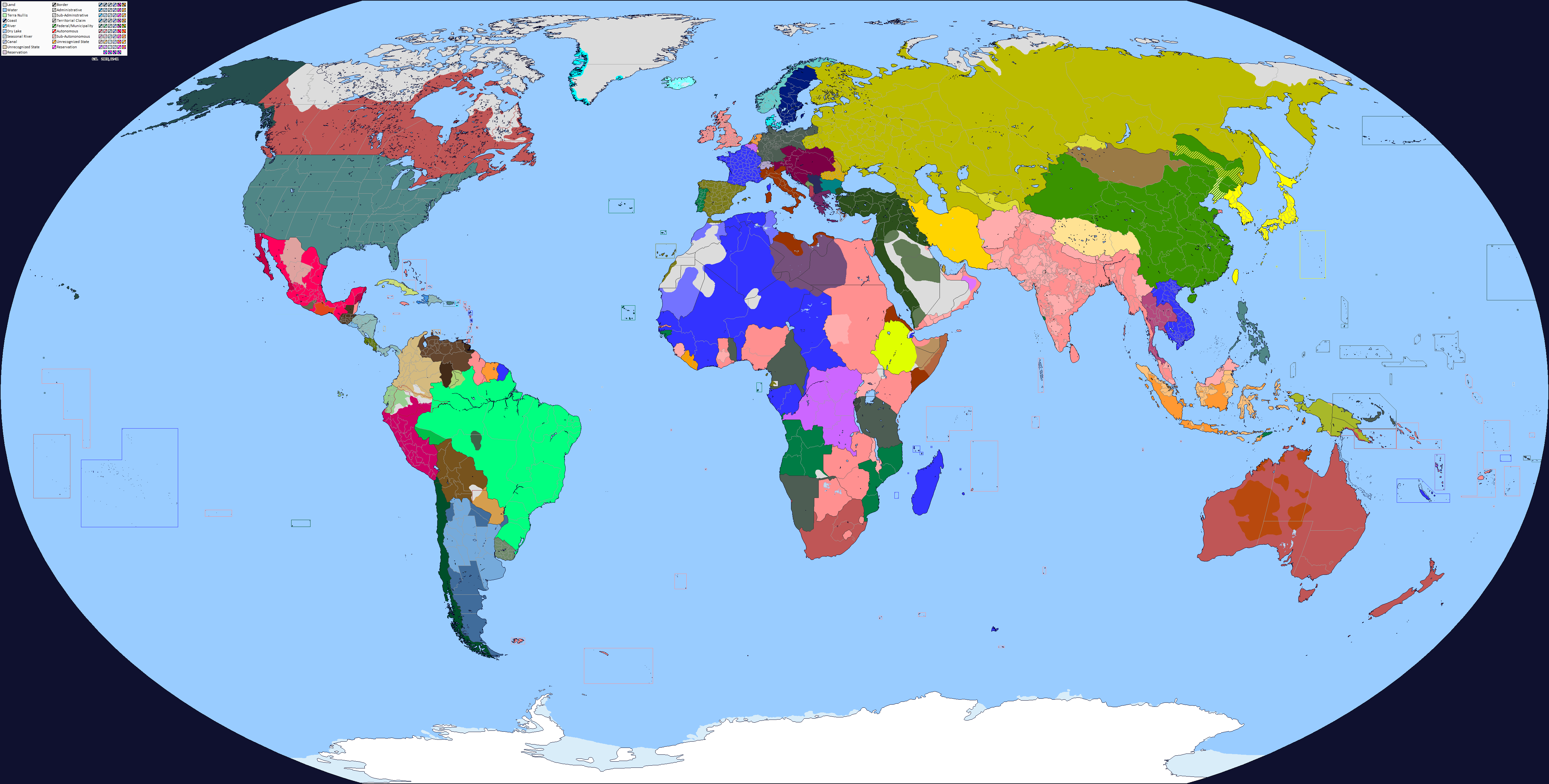
 Sharklord1 — World Map 1914 (Colored+Improved)
by-nd
Sharklord1 — World Map 1914 (Colored+Improved)
by-nd
#imperialism #map #worldwar #britishindia #britishraj #republic_of_china #mexican_revolution #history_map #british_india #austriahungary #france #historical #history #maps #ottomanempire #russianempire #serbia #unitedkingdom #unitedstatesofamerica #worldwar1 #worldwari #worldwarone #britishempire #republicofchina #historymap #germanempire #mapsandflags #historicalmap #unitedkingdomenglandbritain #chineserevolution
Published: 2018-05-16 01:12:40 +0000 UTC; Views: 45292; Favourites: 116; Downloads: 603
Redirect to original
Description
This is my improved and colored map of my older and less detailed, blank world map 1914sharklord1.deviantart.com/art/…
It was a significantly more difficult map to make than the 1942 one, and there are still a few things I am not confident are right because i've not been able to find enough data for it. However, 96% of this map is accurate.
If you have any questions about said map, please ask; as for corrections, tell me them so this thing can be improved; if you have a q-bam of a certain area of administrative boundaries that were not previously on this map, please tell me. This map, I want, to have it achieve a final version so that it can be used and easily navigated.
All sources used, I thank you.
Related content


Comments: 27

👍: 1 ⏩: 0

👍: 1 ⏩: 0

Was Oaxaca independent during this time (hence why it is colored differently)?
👍: 0 ⏩: 1

according to omniatlas
👍: 0 ⏩: 1
I'm not as familiar with this area, but from what I know, Oaxaca either briefly or tried to declare independence from Mexico around this time, during the Mexican Revolution. As a coin collector, I can confirm that Oaxaca minted their own Oaxaca Pesos during this time.
👍: 0 ⏩: 1
That would suggest that they believed they were independent, though it could not have been for very long.
👍: 0 ⏩: 0

what is that grey area that stretches from NW British East Africa to SE Sudan (& SW of Ethiopia)?
👍: 0 ⏩: 1
Inhabited land that is claimed de jure by countries.
Specifically for this map, the Turkana people
👍: 0 ⏩: 1
👍: 0 ⏩: 1
I think so. Wake Island, Midway, and I don't know about the others off the top of my head.
👍: 0 ⏩: 0

Mafia island wasn't a british colony. It was part of German East Africa
👍: 0 ⏩: 0
Amazing Work. I hope u will make the same with the post-war period
But u made some mistakes:
- the kionga triangle was part of german east africa
- Mauritius was a british colony
- Nauru was a german colony
- Sint marteen and sint eustatius were dutch colonies
- northern part of sint marteen was a french colony
And i think botswana and zambia were protectorates
👍: 0 ⏩: 0


I think that this is a very good rendition and the only suggestion that i might offer is that a key to what the differing colors relate to.
While most of the African possessions are somewhat easy to determine the various sub-regions in Mexico for example are difficult to ascertain though i am aware that this was a time of great rebellion and revolt across that country.
I don't that that revising this work would be needed just perhaps a separate key. Still a fine work.
👍: 0 ⏩: 0

The color scheme is an eyesoar but damm this map is good.
👍: 0 ⏩: 1
What’s wrong with the color scheme? And thank you
👍: 0 ⏩: 1
The grey is kinda bad. T.A.C.O.S says you should use the light green ish for it. And it is a little bright.
👍: 0 ⏩: 1
... the lands nobody lives on...
👍: 0 ⏩: 1
The green sucks for that. It blends to much with the other colors around it
👍: 0 ⏩: 0


what us that darked color in that region in Brazil near Bolivia
👍: 0 ⏩: 1
this is like a revolution or a revolt?
👍: 0 ⏩: 1
No it’s just not been conquered by military forces
👍: 0 ⏩: 0