HOME | DD
 Skipr14 — [5001x3670] Languages of European America
Published: 2020-11-15 11:53:35 +0000 UTC; Views: 9670; Favourites: 142; Downloads: 29
Redirect to original
Description
-- Author's Note --
Finally! This one was by far the longest map I have worked on. Thank you so so much to Wannabee for helping me with this, they also wrote the lore shown below. Give them some love!
Also, I do commissions now. So if you're interested, hit me up on:
Discord : Skpr#9670
Reddit : u/Aurcoux
DeviantArt : Skipr14
Hope you enjoy it  (Smile)")
--
This map is part of the alt-hist timeline Roses, Tulips, & Liberty (RTL), which explores the premise of a stronger Dutch influence in North America since the 17th century. Check out r/RosesTulipsAndLiberty for all maps/content in this series.
--
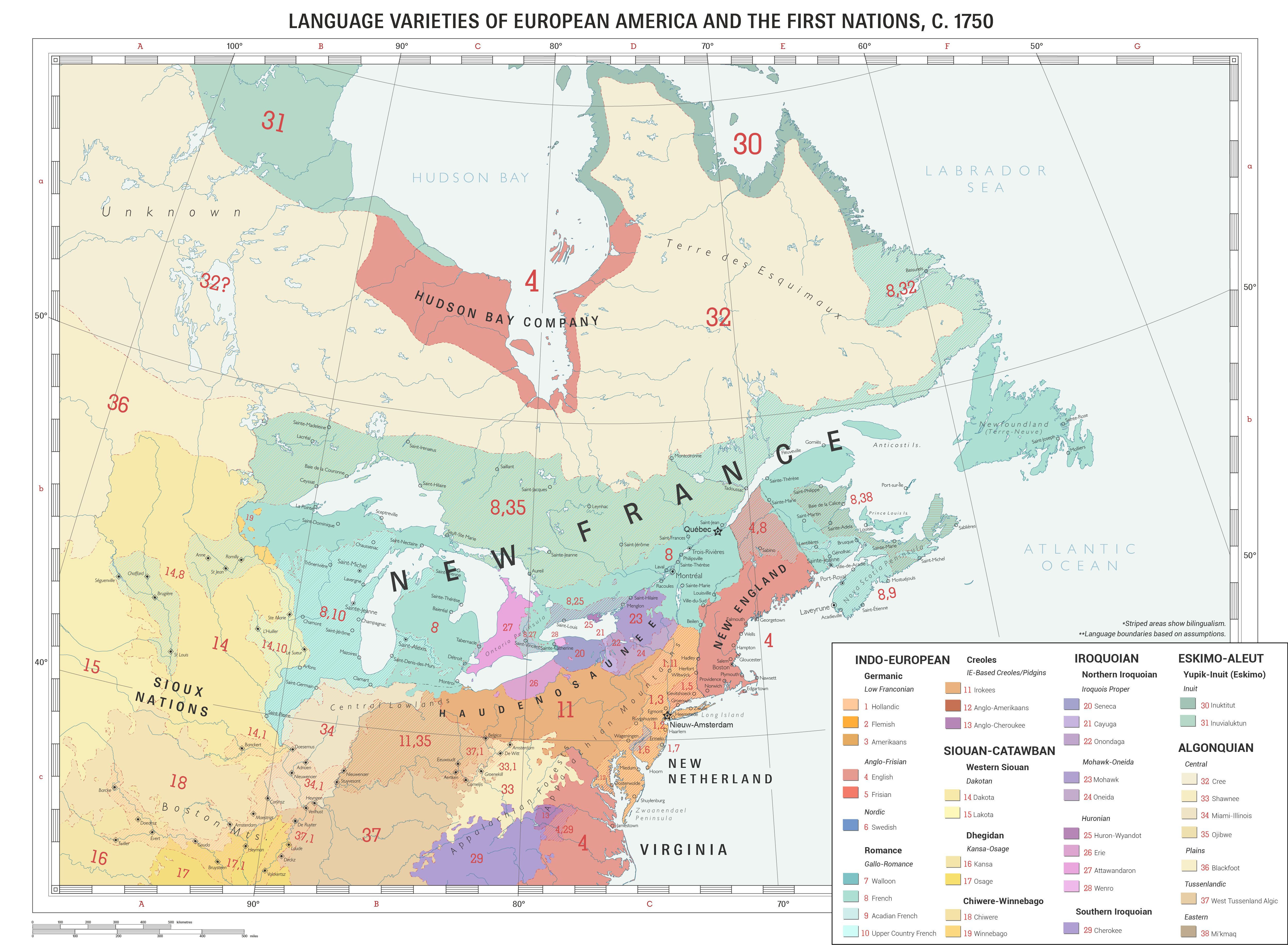
This is a map of the American east coast as known by the Dutch in 1750. This map is a compendium of the works of Wouyt Huybrechtsz de Vlaeming (1716-1770), an ethnographer from New Amsterdam who was appointed by the Dutch West India Company as the ambassador to the Haudenosaunee in 1740. Given the time, de Vlaeming's map might not be the most accurate linguistic map, but it would be heavily used as a reference in the many decades to come.
Linguistic Development
In this timeline, the development of the linguistic situation would be different due to the changed historical circumstances. A notable difference would be the pluricentric nature of Dutch in this timeline. Due to a larger Dutch influence, the linguistic classifications of Dutch became a spectrum ranging from Dutch dialects such as Hollandic and Flemish (as distinguished separately on the map), Dutch-based creoles such as Irokees, to languages completely treated as separate such as Amerikaans. In this timeline, Amerikaans originally referred to the Dutch-variation spoken by the colonists of New Netherland, but soon converged with Irokees-creole and is considered as a single language in the modern-day.
The Dutch and the Haudenosaunee
The Dutch had found themselves establishing New Netherland in the 1620s, which by now had become a populous Dutch-speaking settler-oriented colony. The Dutch also found allies in the Haudenosaunee, which has crucial effects on the development of the fur trade and Dutch colonization in the coming years.
In this timeline, the Beaver Wars still happen. However, the timeline's point of divergence (in 1654) slightly changes the course of events. After the States-General expels Peter Stuyvesant (the Director of New Netherland during the PoD) from New Netherland and gets replaced by Adriaen van der Donck, the attitude of New Netherland towards the Haudenosaunee shifted to armed cooperation. Under his leadership, the Haudenosaunee's strength was bolstered, and they were able to keep the French up north and her Algonkian allies at bay.
Also due to this cooperation, the Dutch were able to defend New Netherland during the 2nd Anglo-Dutch War, and English land west of the Versche river (Connecticut River) was taken in the resulting treaty. Meanwhile, the Dutch States General granted a new charter for the Dutch West India company allowing them to conduct trade and build forts west of New Netherland and into the heart of the continent, and eventually down the Mississippi. This area was soon known as Tussenlandt (from Dutch tussen (in between) + -landt (country). The Dutch West India company had then established a monopsony over the fur trade, benefiting both the Dutch and the Haudenosaunee.
Their cooperation had eventually caused languages to converge in the form of the Amerikaans language, which would then be the official language of several North American nations in the modern day.
The French In North America
There is also the French (New France), who by this time had already settled near the Great Lakes region (known to the Dutch as Meerenlandt). The region had become overwhelmingly Francophone in the area, even developing a French variant called Upper Country French, which incorporated elements from surrounding Algonquian and Siouan languages.
However, in 1750, a colonial war known as Price Maurice's War was fought by the French (and Algonquins) against the Dutch and the Haudenosaunee. In the resulting treaty (1755), the French had ceded the great lakes region and western parts of the Mississippi basin to the Dutch and had been integrated into Tussenland since then. (See the aftermath of the war in this map). Despite this, the region has remained strongly Francophonic to this day.
Related content


Comments: 16

👍: 0 ⏩: 1

👍: 0 ⏩: 1
👍: 0 ⏩: 1
👍: 0 ⏩: 1
👍: 0 ⏩: 1
👍: 1 ⏩: 1
👍: 0 ⏩: 0


👍: 1 ⏩: 1

👍: 1 ⏩: 0

👍: 1 ⏩: 1

m.youtube.com/watch?v=do8oZTR9…
(It is best to watch it in FULL SCREEN MODE)
👍: 0 ⏩: 0