HOME | DD
 snapshot-anterra — Tiperyn Linguistic Map by Tiperyn
#ah #alternativehistory #cartography #celt #commission #creativewriting #culture #ethnicity #ethnography #fanfiction #fantasy #frisian #historical #history #language #linguistics #map #mapmaker #maps #narrative #naruto #nationstates #roleplay #theocracy #vector #worldbuilding #mapmaking #alternateuniverse
Published: 2018-05-17 22:05:23 +0000 UTC; Views: 3536; Favourites: 37; Downloads: 22
Redirect to original
Description
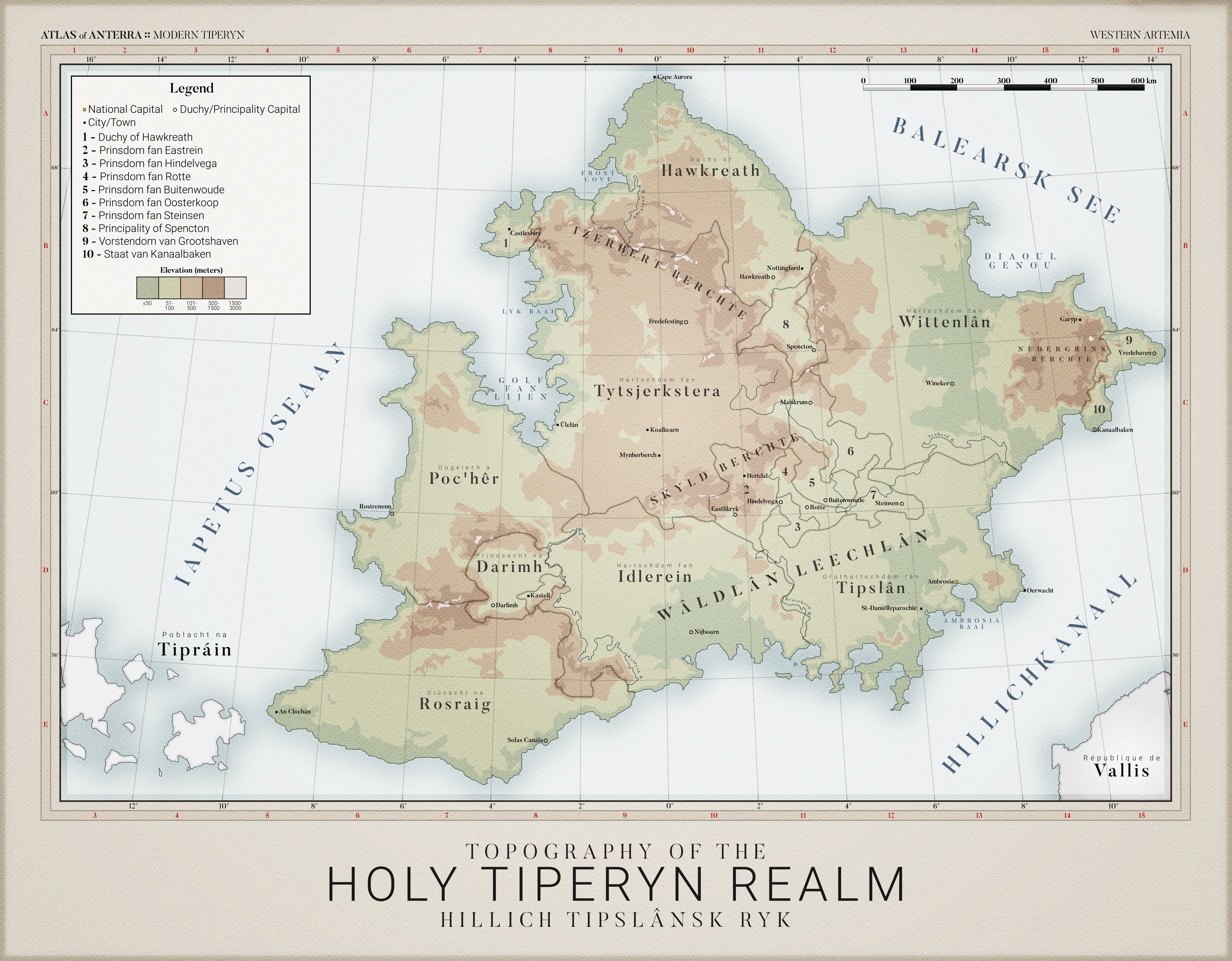
The Holy Realm of Tiperyn is dominated by the West Frisian-derived language of Tipslansk, with 69.02% of its 121 million strong population and the majority of its most powerful duchies speaking the language. Additionally, Anglan (English) is common in its mountainous and boreal northern regions, being the official language of the Duchy of Hawkreath and Principality of Spencton. Both languages are considered indigenous to the island, but did not interact in any substantial way prior to the 16th century due to the Izerhert Mountain Ranges.Additionally, western Tiperyn primarily speaks Celtic languages, with Goidelic (Irish) being the largest and Brittanic (Breton) being the official language of the Duchy of Poc'her around the metropolis of Rostrenenn. While Goidelic is believed to have originated in modern-day Tiprain, Brittanic likely developed after the Celtic migrations to the island of Tiperyn.
There are two major continental languages present in Tiperyn: Vallisian (French) and Hollanske (Dutch). The former is mostly centered in the peninsular lowlands of southern Tiperyn where the distance between Vallis and Tiperyn across the Hillich Channel is the narrowest. Meanwhile, the latter is focused in the east in the Principality of Grootshaven and the State of Kanaalbaken. It is believed that the development of Hollanske was the result of West Germanic migration to the Tiperyn Isles in the 5th Century. However, these ancestors likely did not interact with the ancestors of the island's Tipslansk and Anglan-speaking population who likely migrated to the isles as early as the 1st Century due to the Nedergrins Mountain Range separating the peninsula from the rest of the island.
This was created by community member Tiperyn (BCMatsuyama). Want in on the community that this map was made for? Check out Anterra at our Discord !