HOME | DD
 1Wyrmshadow1 — Lada Terra Venus, Map and Flags

#flags #map #venus
Published: 2018-04-02 22:21:12 +0000 UTC; Views: 5089; Favourites: 57; Downloads: 57
Redirect to original
Description
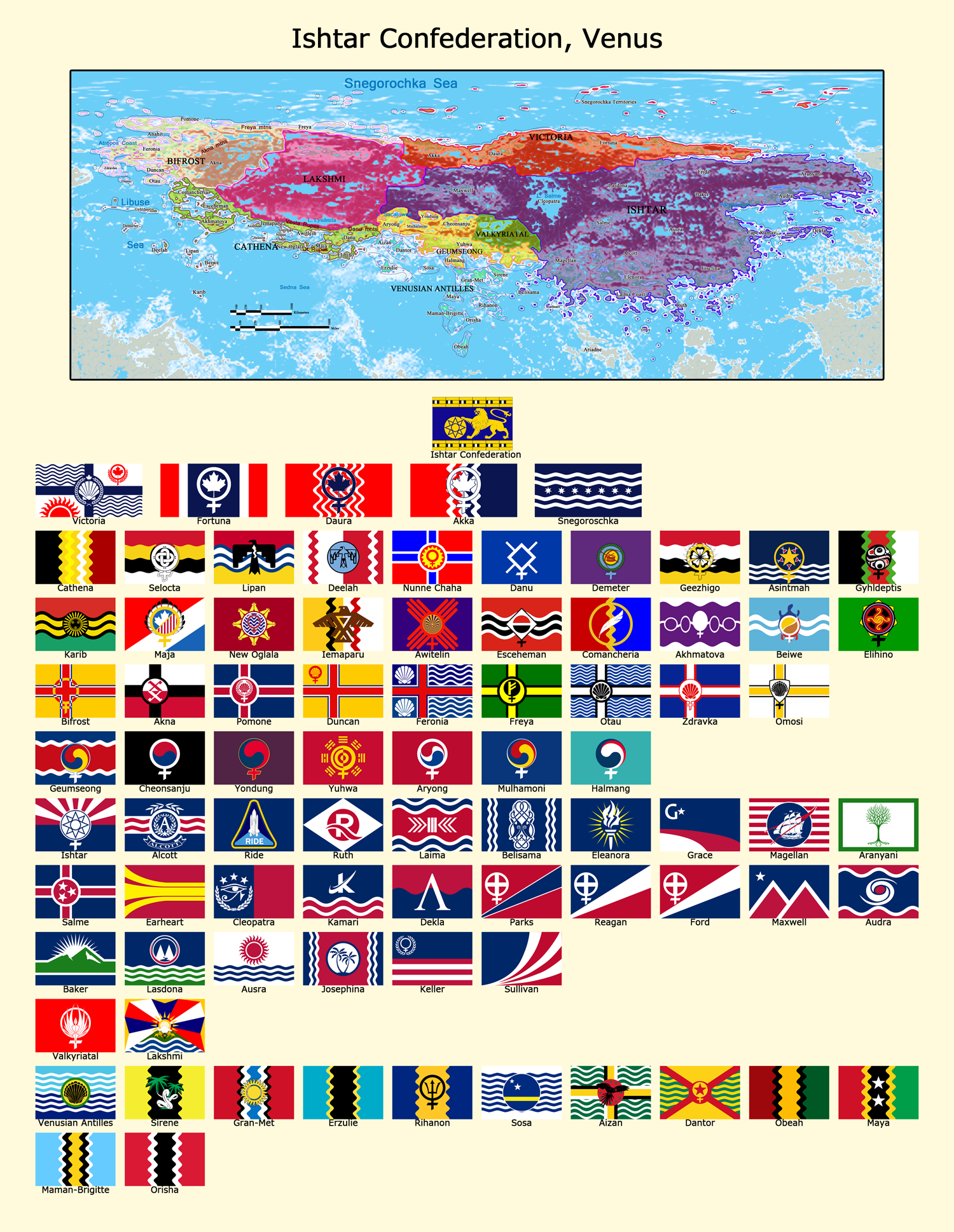
This is Latin-American Venus.Related content


Comments: 11

Is there a specific database you use as a base for all of your flags? I notice many are edited versions national or subnational flags, but many more are simply puzzling. Even the great CRW flag database can't help me figure them all out!
👍: 0 ⏩: 1

Any information I can find I use as inspiration. CRW does have a lot but the colors are sometimes lacking.
👍: 0 ⏩: 1
Ah! Giving us all the challenge of research!
👍: 0 ⏩: 2
👍: 0 ⏩: 0
Well I've made a bunch of templates, then I look up iconography and colors that are in each nations history or current provincial flags and I start mixing things up and see what works. Sometimes I copy a flag design but swap out certain styles with my own 'Venus' motifs like the wavy lines instead of strait bars.
👍: 0 ⏩: 1
Well, the reason I ask is because I'm actually heading a team that is working on a massive Lego model (1:110 scale, with each pixel being a standard 32x32 baseplate) of a fictional planet. We chose a terraformed Venus because it offered the most variety in landforms. While we plan to create my own history and culture for this planet (and thus the model), I have been eyeballing using your national boundaries. Knowing in general what entities your nations represent may actually help me and my team better figure out a general blueprint for history and culture.
👍: 0 ⏩: 0

How long did this take to make? What software did you use to make it? Is it just me or are the lines near the borders dashed? If so, how did you achieve that with the mathematical precision necessary to properly distance the maritime borders from one another?
I'm sorry for being so inquisitive, I just really find the map interesting. I've got to applaud you for your font usage and text orientation, too, since I know what a pain in the ass that can be from experience.
")
👍: 0 ⏩: 1
Just using regular photoshop. As for the maritime borders.. I used the wand select tool to select the area of the country... expanded my selection by X pixels, rounded my selection by 5 pixels, traced the selection into a Work Path, used the pencil tool at 2 pixels wide and 200% distance to trace the path. All this was by the program, not by hand. So if you understand PS, you understood what I wrote. The parts where the border overlapped other countries, I merely erased.
As for how long? I've been working on this for weeks. Hard part is assigning names from NASA maps.
👍: 0 ⏩: 1
Ah, sounds like what I regularly do, though the extra steps sound like they'd help in some situations. Thanks!
👍: 0 ⏩: 0

