HOME | DD
 Abadir — TMM - Political Map of Ferelden Reference
#mabari #map #merry #political #tmm #felreden
Published: 2015-01-26 15:50:00 +0000 UTC; Views: 12765; Favourites: 80; Downloads: 100
Redirect to original
Description
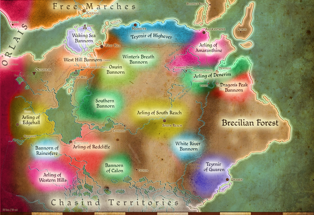
THIS IS A RESORCE FOR THE MERRY MABARI RPG GROUPWhile lore friendly, no accuracy claims are made.
This are the (loose) locations of the known fiefs of Ferelden, reconstructed from Origins and Inquisition maps as well as Dragon Age Legends (location of the Waking Sea Bannorn) and the Tabletop RPG (Edgehall).
The "No-lords lands" are of unknown attribuition and can be used by GMs to set new bannorns for their quests, except for the Brecilian Forest that seems to be "free land".
Note that in Dragon Age: Origins the arling of West Hills created confusion with the bannorn of West Hill city, and it carried in Inquisition as well when the heraldy attributed to the arling in Awakening - a ram's skull - appears on the War Table map by the city of West Hill location. For all those reasons, it was used the Tabletop RPG alternate name "Western Hills" for the arling.
As RP convention, the Merry Mabari and the surrounding towns are considered territories of the Arling of Denerim.
Known feofees in 9:29 Dragon:
(nobles marked ith a * are only mentioned in coversations and codex entries and never appeared in games)
Gwaren - Teyrn Loghain McTir (Origins)
Highever - Teyrn Bryce Cousland (Origins)
Amaranthine - Arl Rendon Howe (Origins)
Denerim - Arl Urien Kendells* (Origins)
Edgehall - Arl Fergus Lendon* (Tabletop RPG)
Redcliffe - Arl Eamon Guerrin (Origins)
South Reach - Arl Leonas Bryland (Origins)
Western Hills - Arl Gallagher Wulff (Origins)
Calon - Bann Elarra* (Inquisition)
Dragon's Peak - Bann Sighard (Origins)
Oswin - Bann Loren* (Origins/Inquisition) - Not to be confused with "Caer Ostwin" in Inquisition
Rainesfere - Bann Teagan Guerrin (Origins)
Southern Bannorn - Bann Ceorlic (Origins)
West Hill (city) - Bann Franderel* (Origins)
Waking Sea - Bann Alfstanna Eremon (Origins)
Winter's Breath - Bann Telmen* (Origins)
White River - Bann Reginalda*(Origins)
The following don't appear in the map due to overlaying or unknown position/Arling
City of Amaranthine - Bann Esmerelle (Awakening)
Dragonmount* - Uknown Bann (possibly Bronach, Darby or Perrin) and position (possibly in the eastern bannorn)
Unknown - Bann Bronach* (Origins - codex/conversation)
Unkown - Bann Darby* (Origins - codex/conversation)
Unknown - Bann Perrin (Leliana's song/Da2)
If you find inconsistencies or new sources, please note me: I consider this a WIP work and I'll be happy to update.
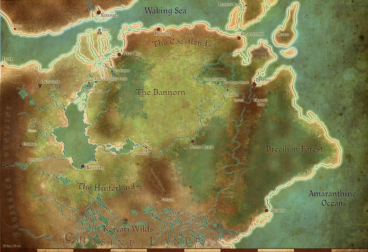
Geographical version:
Related content


Comments: 23

Let me express my thanks for this map. I used it extensively when writing the last chapter of my fanfiction.
That said, I imagine lots of young people learning Ferelden geography must have been cursing whoever named West Hill and Western Hills.
👍: 0 ⏩: 1

I'm young only by over-sixty standards and I cursed them too... :\
👍: 0 ⏩: 0

How did you pinpoint the White river bannorn? I was always under the impression that it was located to the North closer to Highever.
👍: 0 ⏩: 1
Bann Reginalda's territories are supposedy under the influence of Gwaren, according to Origins; you are right though: there is a White River near the orlesian border ( dragonage.wikia.com/wiki/Ferel… ), but the two may not be related (see where is West Hill city and where is the West Hill arling that I signed as "Western Hill" to avoid confusion).
to be completely honest, I thought the unnamed river running along the southron hills might have been this "white river", but it clashes with the battle location (unless the "regiments of chevaliers"travelled by sea and came from Denerim 
Unfortunately BW isn't much consistent with its geography (see Redcliffe in Origin and Inquisition).
👍: 0 ⏩: 0

Hi, i really liked your map. First, sorry my english, now let me tell you that i was researching in Dragon Age's games, wikis, the roleplaying-game to do exactly what you do. I found an inconsistence in the location of Honleath (the place where Shale is found), it supposed to be in the south of Redcliffe, in the Hinterlands, close to the fallow mire.
I really appreciate you work
")
👍: 0 ⏩: 1
yes, I noticed, I mixed up the map markers

👍: 0 ⏩: 0

Oh! there are notes that the southern bannorn borders gwaren!
👍: 0 ⏩: 1
forum.bioware.com/topic/84452-…
This response from Mary Kirby (along with the heraldies on the world map in Inquisition) makes it a tad complicated to understand how the lands are in fact distributed. According to her "South Reach is between West Hills and Lothering" which means it shoudl encompass the eastern lake calenhad shore north to south BUT "Southern Bannorn [...] is on the eastern shore of Lake Calenhad" so in the lands of the South Reach Arling, and this doesn't count neither the "Bann Loren's Land" (here "Oswin Bannorn") that appear in Rerturn to Ostagar on that point on the map, nor the note of the southern bannorn bordering Gwaren.
The explanation might simple: Bannorns are PART of Arlings and Teyrnirs (see City of Amaranthine as part of the ARLING of Amaranthine) so The Teyrnir of Gwaren (which probably reaches the drakon river east of the CITY of South Reach) borders the Southern Bannorn (that probably extends on alòong the whole southern side of the Bannorn, north of the Imperial Highway) which is PART of the South Reach Arling, as is probably Oswin's Bannorn and Lothering (which is not included into the "South Reach" as it's a "more or less" territory thing.
In fact, also Rainesfere and Calon are considered "part" of the Arling of Redcliffe, (the first is ruled by Teagan until he becomes Arl but he's always to be found in Redcliffe itself, while the second is clearly stated as "part of my domain"by Teagan himself in the war table "The Arl's Invitation" in DAI) so that's not unlikely.
👍: 0 ⏩: 1
Don't even get me started on the map in Inquisition and how it messed with heraldry. I know how they were part of each other. It just seemed a bit odd to me that one would specifically mention that the Bann of The Southern Bannorn caved to Loghain because their lands where next to each other, If there are these other Banns and Arls much closer who did not.
I mean it could totally be because of the family history when it came to things but it seemed like one would mention that instead of them being close to each other.
I know the info about them being close comes from in game and comes much later than when Mary Kirby gave her input.
But at the same time assuming that it is referring to Gwaren as a Teyrnir does make all the info we receive technically true. If just kind of odd.
If you want I can stop commenting on this? It has always been my default go to map so when I find a possible inaccuracy I like to bring it up. But if it's coming off as rude I can stop?
👍: 0 ⏩: 1
I actually do like input and comments, thing is Fereldan geography is quite messed up, so at some poit I guess we have to make choices.
Thing is, Dragon Age has had 3 games, each one with its own development and probably its own development team. While some may argue there SHOULD be someone to check over continuity errors, I darewsay might be not the case... see The Elder Scrolls franchise: in Arena (first game in the series) you had the whole continent of tamriel mapped, with cities, villages, hamlets and such. Then in Daggerfall the most prominent city of one province moved on the othjer side of the peninsula it was in... then in Morrowind a place which was a main level of the first game change position and looks... in obhlivion an entiure city becam a fort (Sutch, restored by modders) and in Skyrim a city (Markarth) moved 40/60 km to the east... AN OLD DWARVEN CITY older than the timeline of Artena itself. And don't let me start on The Elder Scrolls Online...
The same thing has likely happened in Dragon age: since there was no strict definition of the bannorns and arlings in Ferelden (or perhaps they were considered "outdated" after DA")
This probably happens WAY more with regions that share the same name (i.e. West/ern Hills and South(ern) Reach/Bannorn) that might likely get mixed up. As the official map states some thing (i.e. the position of West Hill and South Reach cities) and the game states other things (West HillS bannorn) and developers thates other things (i.e. South Bannorn being "east of southern lake calenhad's shore") I had to make it workj in one map... hence also the decision to make "blurred spots of colors" instead of proper borders
 (Smile)")
👍: 0 ⏩: 1
I confess I never played Arena or Daggerfall. but man Morrowind WAS my childhood. Oh yeah! when I saw what they had done with The Elder scrolls Online it was like entering a horror movie lore wise! Skyrim also copped out on winterhold completely. I mean I understand and all but there should have been way more rubble left behind! I DID LOVE the Pilgrim's Trench though! That had me spazzing! Right back to DA
That makes a lot of sense! I just kinda assumed the blured color spots where a way of showing that lots of freeholders would swear to a particular noble instead of just a certain city.
And you are right. Things do change. Especially with the whole freeholder system and loose politics of Ferelden.
Its very Fereldan to do this though. I can imagine the Orlesians screaming their heads off.
👍: 0 ⏩: 1
it is also very Fereldan to change completely the geography of Haven and Ferelden in the span of ten years (and I don't mean the map but the terrain itself... may it be an effect of the blight? Does the archdemon reshape hills, slopes and moves lakes too?)

👍: 0 ⏩: 1
Hah! It completely is though! You know... Its not as bad as a rock falling from the sky causing a chain reaction that somehow wiped out pretty much an entire province
I SWEAR TO THE MAKER TITANS IF YOU SO MUCH AS....
From what I've read about the blight after the blight the land goes through a "thawing" Ferelden was only blighted for a year so it's not in that bad shape. But I'm pretty sure that would only be the climate and fertility of the land. But here's the thing. WE DON'T KNOW! I mean I swear the archdemon must have had a field day
"Oh one moment! stop the hoard! I have to mess with their geography!"
👍: 0 ⏩: 1
you know, if you're right the titans may have become Bioware's ex-machina to explain a good chink of the redesigns...

👍: 0 ⏩: 1
Now if they could only explain the freaking change of HERALDRY in DAI that happened so quickly. Well and tons of other shit but the heraldry really bugs me. THAT IS NOT TRADITIONAL QUARTERING
👍: 0 ⏩: 1
BW: "LOL retcon"
I knew we had to be harsher when they started with the DA2 redesigns...
👍: 0 ⏩: 0
www.gry-online.pl/galeria/gale… this map also shows diferant heraldry in diferant areas cousland and highever seems fine but there seem to be two in south reach?
👍: 0 ⏩: 0
I found one thing This map: images2.wikia.nocookie.net/__c… shows a differant location for dragon's peak bannorn
👍: 0 ⏩: 1
I had seen that map, but I gather that was a map made DURING the development of Dragon Age origins. This is based on different sources keeping the most recent as "more accurate" and giving the locations in origins (and DAI) prioirty when something was off (i.e. Redcliffe is placed in different gulfs of the south-western shore of Lake Calenhad when both the in-game areas in Origin and Inquisition suggest is in the sout-south-eastern corner, since the docks are always on the north-west/west side of the village).
I had wasted a more than a week of my life over this map, I'm pretty confident over the accuracy and the results, and it's good enough for our RP group. If you want to follow different sources, feel free: this was never meant to be "law" for the Dragon Age lore.
👍: 0 ⏩: 0