HOME | DD
 aeshnidaemaps — The Path of Roland from Tull to the Dark Tower

#beam #blaine #darktower #fantasymap #lud #map #midworld #oy #roland #stephenking #tull #ribbonmap #journey #ribbon #thedarktower
Published: 2024-01-03 19:52:52 +0000 UTC; Views: 2059; Favourites: 11; Downloads: 0
Redirect to original
Description
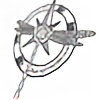
This map shows the path that Gunslinger Roland Deschain took through the eight books of Stephen King's The Dark Tower series, from Tull to the Dark Tower. I decided to draw this in ribbon map style; these were used in the 1500s/1600s to map a journey from one city to another, and also used in the U.S. to map long rivers, like the Mississippi. This map attempts to capture the geography of The Dark Tower - challenging, since the world has moved on. Like the ribbon maps of the 1500s and 1600s, the map begins at the bottom left – note the initial footsteps designed to orient the reader – and ends at the top right. Each ribbon is “read” from bottom to top, as though you’re a traveler looking at the road ahead of you.
As you’d find on old ribbon maps, there are small directional compasses scattered throughout the map. I used a wheel for these small compasses, to represent the concept that ka is a wheel. Embedded in the center of each wheel is the Rose. Also like you’d find on old ribbon maps, I’ve included some numbering and text along the sides of each ribbon. On the ribbon maps used in ye olde England, the side text provided the names of the counties through which the traveler was passing; here, the side text provides the names and numbers of each book in the series (I’m including “The Wind Through the Keyhole” as book 4.5). The arrows with dotted lines between them indicate the end of one book and the start of the next.
The numbers along the road are also typical in old ribbon maps. Usually they marked miles on the road from London to some other city. Here, they mark key points in The Dark Tower story, but without spoilers. They also assist in reading the map in the correct direction. A handful of those numbers are marked with *. This indicates a bit of back-and-forth along the map by the main characters. If you were traveling directly to the Tower, you would simply keep following the road as it spools out ahead of you on the ribbon map.
This map was mostly hand-drawn in Photoshop with a Wacom Intuous tablet; the trees are brushes, as is the skull at Golgotha, and the Nozz-a-la and Takuro Spirit billboards are items that I found on the Dark Tower fan wiki. I’ve reused my other map icons to remain consistent with the look of my previous Dark Tower maps, but switched up the font to be more authentic for a ribbon map. The font is Antiquarian and Antiquarian Scribe.
Related content


Comments: 2

👍: 1 ⏩: 1

👍: 1 ⏩: 0