HOME | DD
 calthyechild — Tolkien-style Map Brushes
by-sa
calthyechild — Tolkien-style Map Brushes
by-sa
#cartography #fantasy #lotr #map #mountain #tolkien #trees #tolkienmap #how_to_make_a_fantasy_map #fantasy_map_brushes #photoshop_brushes_fantasy_cartography #tolkienfanart #fantasy_map_maker
Published: 2009-10-01 00:17:27 +0000 UTC; Views: 287472; Favourites: 2804; Downloads: 65089
Redirect to original
Description
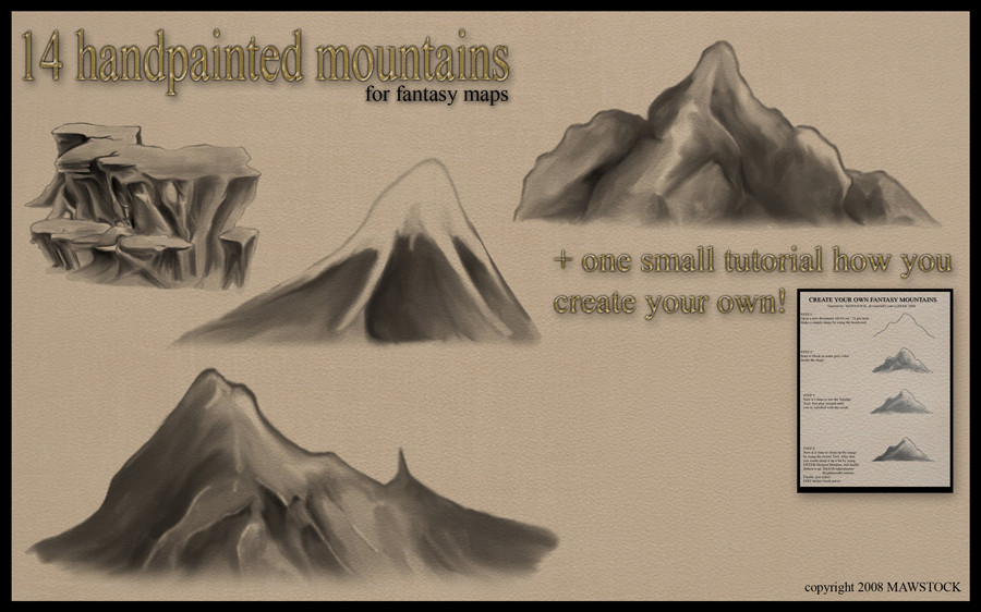
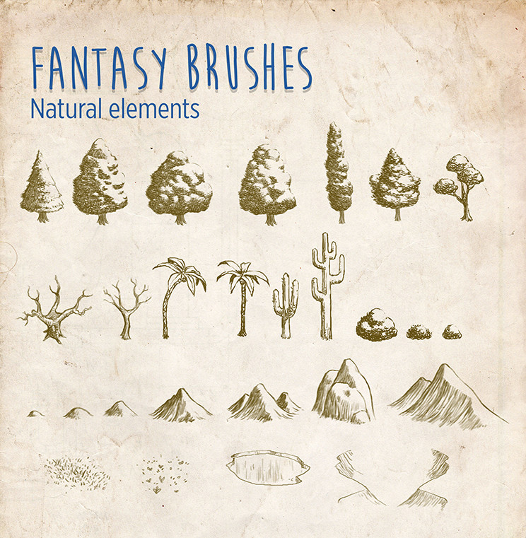
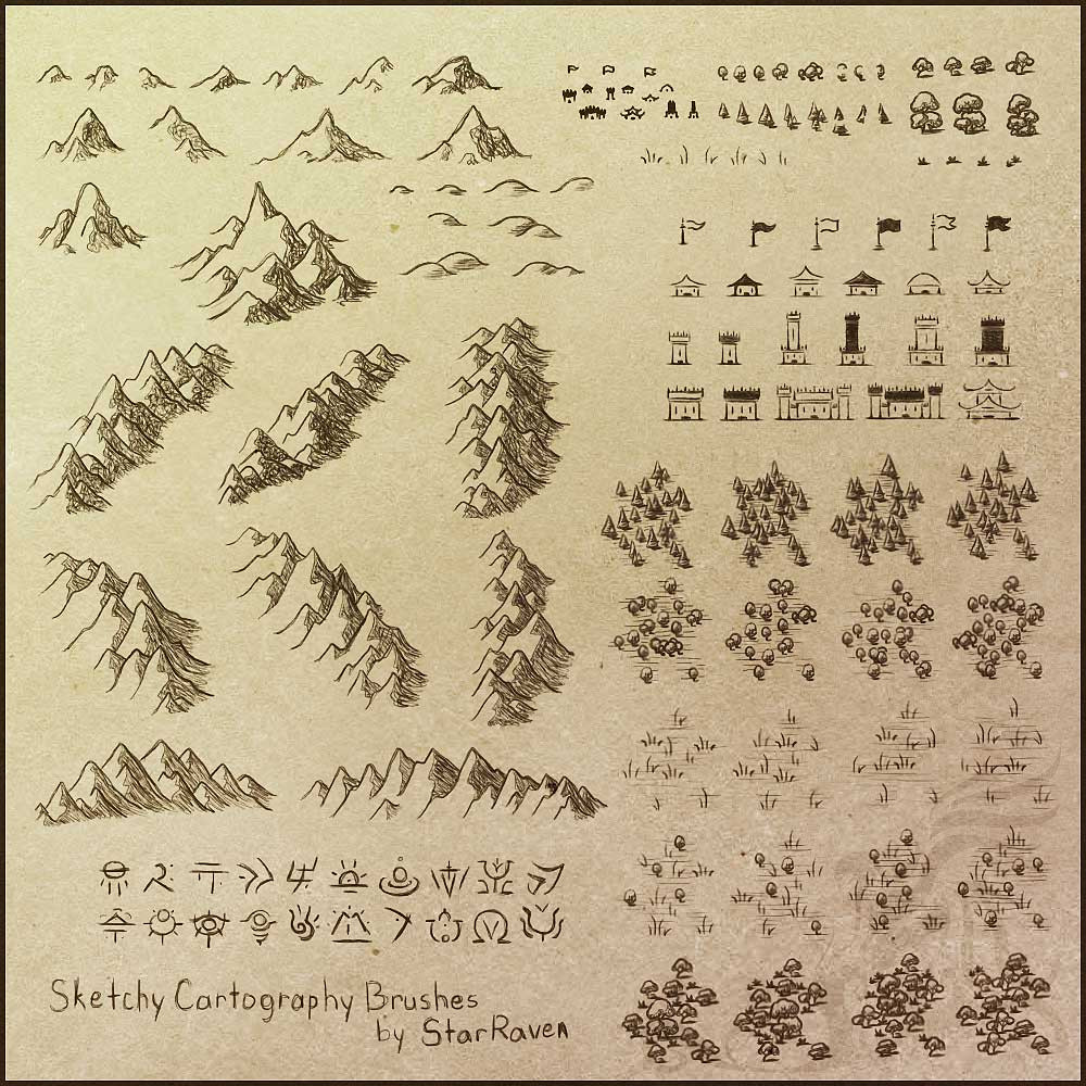
14 MORE MOUNTAINS HERE: calthyechild.deviantart.com/ar…Image pack HERE: calthyechild.deviantart.com/ar…
EVEN MORE ICONS, PLUS A FONT, PLUS TEXTURES, PLUS CONTINENTS AND A TUTORIAL FOR HOW TO MAKE YOUR OWN MAPS HERE: calthyechild.deviantart.com/ar…
All the free fantasy map generator related things I could find: feedthemultiverse.com/free-fan…
Realized you made a horrible mistake by trying to make your own map? My fantasy map portfolio is available at www.feedthemultiverse.com and I am available for hire.
")
converted this and the "I want more mountains" brush set for the GIMP with my permission and can be found here. thewhitecrayon.deviantart.com/…
Someone on Reddit converted these to WONDERDRAFT BRUSHES! www.reddit.com/r/wonderdraft/c…
Yes, you too can convert them to any program you would like and if I find them or you send em to me, they will be added.
It has come to my attention that this post shows up when you search for "How to make a Wondermap Map Brush" probably because of that comment above. The answer to how to make a wonderdraft map brush of course WAS NOT ANSWERED in this listing... UNTIL NOW. If you came here hoping for the answer to that question, here you go:
How to make a Wonderdraft Brush
First get a png of the brush you want. All Wonderdraft assets must be png files, nothing else will work. Now you must place it in the right spot in the Wonderdraft folder. Where I write "NAME-OF-PACK" name the group of brushes. For example you might put my brushes in a file labeled "Tiffany Munro" "Calthyechild" or "Feedthemultiverse". Where I write NAME-OF-ITEM-TUBE, this will be named after the GROUP of items that you are placing in that folder. For example, "Pine trees" "Palm trees" "Volcanoes" etc as the program will cycle through those images as you use the brush.
To make a BRUSH for landscape/sea texturing, place it in the primary Wonderdraft folder, that is C/(your username)/Roaming/Appdata/Wonderdraft/brushes/NAME-OF-PACK/(image files go here)
To make a TREE brush, place it in C/(your username)/Roaming/Appdata/Wonderdraft/assets/NAME-OF-PACK/sprites/NAME-OF-TREETUBE/(image files go here)
For the tree brush if you put multiple files in that folder, you can repeatedly put down several trees.
To make a MOUNTAIN brush, place it in C/(your username)/Roaming/Appdata/Wonderdraft/assets/NAME-OF-PACK/sprites/mountains/NAME-OF-MOUNTAIN-TUBE/(image files go here)
Mountain brushes are like tree brushes, you can put multiple in here.
To make a SYMBOL brush, C/(your username)/Roaming/Appdata/Wonderdraft/assets/NAME-OF-PACK/sprites/symbols/NAME-OF-SYMBOL-TUBE/(image files go here)
Symbol brushes aren't exactly the same but the place they go uses the same logic.
To make a PATH brush: C/(your username)/Roaming/Appdata/Wonderdraft/assets/NAME-OF-PACK/textures/paths/(horizontal looping image files go here)
These must be horizontal looping ribbons or it won't look right. Think of it as like a ribbon being laid out.
To make a TEXTURE fill:
Textures must be a seamless png. No other file type will work. They cannot be resized in the program, so please make them appropriate in size for the sort of texture if it were placed on a printer paper/standard screen map.
Ground textures go here: C/(your username)/Roaming/Appdata/Wonderdraft/assets/NAME-OF-PACK/textures/Ground/(image files go here)
Water textures go here: C/(your username)/Roaming/Appdata/Wonderdraft/assets/NAME-OF-PACK/textures/Water/(image files go here)
How to make a Wonderdraft frame:
Make a square png that is the full round of the frame with all sides/corner icons in place. Then place it here: C/(your username)/Roaming/Appdata/Wonderdraft/assets/NAME-OF-PACK/textures/Frames/(image files go here)
Want more Wonderdraft and DungeonDraft tools? Have money? My paid assets can be found on Cartography Assets! Check them out for Wonderdraft appropriate tools! cartographyassets.com/creator/…
Want assets for Roll20? marketplace.roll20.net/browse/…
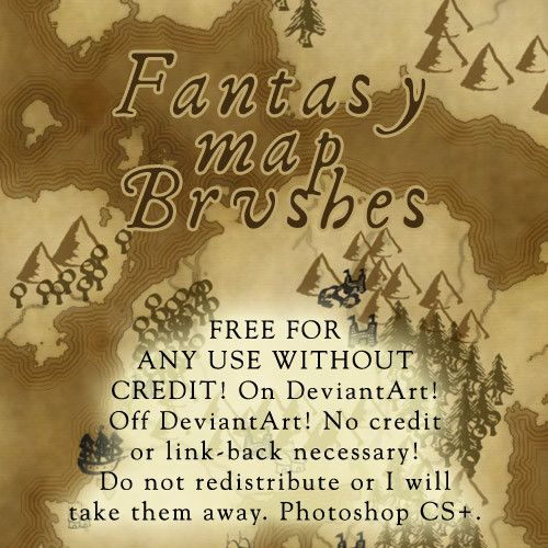
Have you ever wanted to make a FANTASY MAP and been too lazy to make your own vaguely mountain and treeish shaped blobs?!?!?! NOW YOU TOO CAN MAKE A FANTASY MAP! Includes VAGUELY TRIANGULAR SHAPED BLOBS MASQUERADING AS MOUNTAINS! VAGUELY TRIANGULAR AND HAIRY SHAPES PRETENDING TO BE TREES! CIRCLES WITH A LINE ON THE BOTTOM PRETENDING TO BE A TREE! TERRIBLE-QUALITY HOUSE-ISH SHAPES! A DREADFUL LOOKING COMPASS ROSE! A FEW GRASS SHAPED BLOBS! AN ABSOLUTELY USELESS PILE OF ROCKS! AND MANY MORE SHAPES THAT YOU WILL PROBABLY NEVER USE BUT YOU'LL DOWNLOAD ANYWAY!!!!!
Woot! I probably spent no more than 30 seconds on each brush. >_> It's up to you to add scatter effects and figure out how to use them.
As usual: free for use for absolutely everything and anything you feel like, EXCEPT for redistributing the brush pack (unless you converted it to another program and credited me). Yes! Use them commercially! Use them in your comic! Use them in your novel! Use them on your head! Don't credit me if you don't want to! Don't show me if you're too lazy or think it's awful! (but I will fave what's done with my brushes on DeviantArt if I am alerted to its presence.) Edit: I have seen my brushes show up seriously so many times since I made them (it's 2019 at the time of this edit) and all I've ever done is comment "omg I made those hi." Fear nothing, make maps.
If you want to support me, please link to my fantasy map portfolio at www.feedthemultiverse.com or my comic at www.stargazersgate.com .
A fave if you use them, might use them, or like them would be awesome.
Related content


Comments: 293

Excellent!
Gonna use it for my own map. A previous version is done, planning to "update" it:
I'll link you final product when I'm done
👍: 0 ⏩: 1

Nice! Needs a bit of work (two rivers cross over each other), and just to let you know, An Elves' Tale is grammatically incorrect. If you're trying to say it's a tale about a singular Elf, it should be An Elf's Tale, or An Elv's Tale/An Elve's Tale if you want to use to "f to v" change Tolkien employed. Note where the apostrophe goes. Can't wait to see the final product
👍: 0 ⏩: 2

Not quite. It's Elf/Elves, because he modelled it on plurals like life/lives and knife/knives.
👍: 0 ⏩: 1
I know, I misplaced the apostrophe
")
👍: 0 ⏩: 1
XD
I like that "dwarves" entered the popular lexicon, especially since Tolkien created that plural to show how Middle-Earth is *different* from our world where dwarfs aren't an entire culture. He even used "dwarrows" once, following the goose/geese logic.
👍: 0 ⏩: 1
…dwarrows rhymes with geese?
👍: 0 ⏩: 1
It's a linguistics thing. Instead of adding an S, you change the vowel sounds. Goose/geese, mouse/mice, woman/women, and in this case dwarf/dwarrows (or dwerrows).
Both Old English and Welsh, languages that Tolkien studied very closely, featured more of those plurals. Did you know that in Old English the plural of "book" was "beek"? XD
👍: 0 ⏩: 1
Huh. Evidently, I'm anything but a linguistics expert, but I'll take your word for it that this makes sense
...beek. That is weird.
👍: 0 ⏩: 0
It's on plural by purpoise. There's more then 1 elf involved in that haha (BTW I'm not english myself xD)
And thanks for feedback. You should check this out:
Still needs more towns and such. So has to be still modified lol
👍: 0 ⏩: 1
Alright then, it'd be The Elves' Tale, or Tales if there's more than one tale. Better yet, The Tale of the Elves. Doesn't have the same ring to it, but you can't go wrong with a "The X of the Y" title
I'd also suggest a little more variety in the shape of the land - at the moment, it seems a bit too generic fantasy land-ish. Real coastlines have tons of curves, divots and points, not to mention offshore islands, and they're rarely as clearcut as Aegnor is at the time being.
👍: 0 ⏩: 1
Hmm... could add more bays and such, or even bigger lakes inside to make Aegnor a more irregular place. Thanks for suggestion
👍: 0 ⏩: 1


is there a version for sai anywhere? love love LOVE the brushes btw~
👍: 0 ⏩: 0


This is awesome, thanks for allowing people to use it
👍: 0 ⏩: 0


*screams*
This is everything I ever wanted SCREW YOU REALISTIC TOPOGRAPHY. I HAVE RUBBER STAMPS NOW.
(but seriously I was crying over this map I'm making and your stamps were a godsend <3)
👍: 0 ⏩: 1

Well, I hope you found the several other map brush sets in my gallery as well.  (Smile)")
I use my own brushes for map commissions so I share your sentiments on having to hand draw each and every individual little thing. I've made a fairly large variety of brushes, some of which I haven't released yet, because I keep running into new things I want.
Anyway, cheers, and don't cry over maps, they should be fun!
👍: 0 ⏩: 1
Oh I love maps. The crying is just when I can't use the software (I only just switched from hand-drawn to using photoshop). The rest of the time I'm researching plate tectonics and ecology and geology and ranting at anyone who will listen about how you can't have an atoll like all these popular maps have without realising there's a volcano in the middle and that means a seismically active area, and you can't just randomly put mountain ranges everywhere you have to think about them (Tolkien I am looking at your square-ass mountain range), and like, you can't put a desert without putting mountains on one side. Lol I will not shut up about this, world-building is like breathing to me. Don't get me started on fjords. I spent like six hours drawing fjords pixel by pixel. But apparently having to draw trees is too hard and I need a rubber stamp for that. Go figure.

👍: 0 ⏩: 1
My pet peeve is rivers... rivers do not fork off and go in two different directions to the sea, or spring up out of swamps, or spring forth from the middle of a lake and go into multiple directions... little creeks run into big rivers... (facepalm) You know, for fantasy stuff I'm willing to give some leeway for say, Tolkien's square mountain range (it drove me crazy as a kid but I figured it was probably like, a man-made range or something) but without some justification like "we dug it that way", rivers don't go through the entire country from sea to sea either. And then it's not really a river.
But, I do commissions, so I have to work with the person's sketch of how they want their land to be! I usually try suggest changes but if I try make more natural rivers/islands/mountain ranges and they really want their layout, well, then I have to put in the bad geography. Ah well.
All this time though and no one has ever requested an atoll! Go figure.
Anyway, I understand. I devolve into seething rage over rivers... so I really do understand. (grumbles) And it's not like geology is that hard to understand, I'm not exactly highly educated, I know what I know from one little elective I took in high school and like, educational TV shows. I knew about the rain shadow effect when I was 12.
The only really fjordy map I ever did I got pretty nitpicky over the jagged cuts too. But, I still use stamps for my trees! I go crazy drawing each and every little tree. I have a few dozen different trees now, though, varying sized clumps and types of trees instead of just the Tolkienesque circly trees I started with.
👍: 0 ⏩: 1
Rivers still aren't a thing I know much about, so I would probly piss you off with my map (I'm from the desert, is my only excuse. I'm surprised I remember rivers at all), cos I've got it all backwards apparently. Whoops. I guess deltas are what got me thinking big rivers branch off into little ones. Fuck now I feel like I need to redraw my entire Magic Kingdom map. D8 Would you mind having a look and helping me fix the rivers and lakes if they're wrong? I'd be really grateful.
👍: 0 ⏩: 1
Lol, I took a look at your map afterwards and I was like 'WELP'. Wasn't actually pissing on your rivers!
Anyway, you don't need to redraw the entire thing, just reroute a couple of rivers!
Hokay, so! Let's start at the bottom.
Deltas! I love deltas, drawing them is awesome. Basically, rivers always take the path of least resistance. That means that if a river forks around something, eventually it will erode down and start taking the path of least resistance, eventually wearing down so deep that it only goes around one side of the thing. Or, it will wear right down through the thing. So a delta happens when a river is carrying a bunch of sediment. So roughly when it hits the standing water that cannot wash away the sediment fast enough to keep it from building u p, you get unstable routes built up, and things like flooding can make the rivers build up new steeper routes, etc.
So you have two points where you have deltas. The one near Dauphin makes perfect sense. It's cutting through what seems to be unstable swampland, and that's ideal ground to be carrying tons of sediment and then hitting slow moving ocean water. Plus there's a good chance that there'll be flooding in that area which can also contribute to delta formation. The other point where you have a delta, near the top of the map on the right, is also feasible... it looks to me like that's going to be rocky area though so I think it's less likely. Oops, missed one. There's one in the middle by Ufwundria. I'm not sure how I feel about a lake feeding into deltas like that... I'm not sure that the delta could have formed with all of that still water right there. There wouldn't be the impetuous needed to collect all of that sediment. More likely that you'd see a delta leading into the lake, and the lake sort of casually draining into the ocean through a pinch point.
Now, lakes. You have a few major lakes. Around Dauphin it makes perfect sense. Low swamplands. You're going to be seeing rivers spreading out into flat swaths of water in that kind of land, filling up any gaps in the area. In fact, in that kind of area I'd guess there's probably a lot of rainfall, and you're probably going to see some lakes that aren't attached to rivers, just rainfall fed dugouts. The big sea up in Kremlenzra by that delta would probably be the passage the river takes, there's not likely to be a river passing beside that huge chasm of a lake without spilling into it. Path of least resistance here. Pretty much everything else lakeish looks fine. A good classic river to look at is the Nile. upload.wikimedia.org/wikipedia…
You get your large lakes up on higher levels feeding into your rivers, the rivers spilling out on lower, wider points of ground where there's nothing to really hold it in. That's how lakes usually are--feeding a river because they're glacially fed, spring-fed lakes, or rainfall reservoirs. So keep in mind the climate you're seeing... and the overall height of the land. Flatlands will see spillage, rivers widening into lakes. Mountains will see high captured lakes feeding rivers. Etc.
So, keeping in mind the path of least resistance, here’s how your rivers are going to work.
The river between Agraba city is probably fine. You might see a little bit of branching near the top, where little streams run from higher points and get caught up in it. Seeing how it’s going through desert, you may see some points where it branches out. It’s quite straight, and because of that it makes sense that it’s draining into a thin point of land. Likewise, the river to the right of it is probably okay. I would expect to see a few other smaller rivers running into the sea on the opposing side of the mountains there. And probably a larger lake feeding these rivers being as it’s desert and there’s unlikely to be a glacier feeding them.
The river to the LEFT of that is not okay. It’s not going to drain into the ocean at four different points. If you were to split it so there’s a couple of rivers that start up from a point in the mountains there, though, or make it so that instead of four draining points, you see four smaller streams running into it, that would be more accurate.
If you were to make the river that drains near Blaecwymord start up somewhere and run into the main river it would be fine.
The river that starts up by Arborglith and runs through the lake would NOT split off to go up through Schleifenstadt. The lake is obviously lowlands, and while it might delta to enter that lake, it’s just going to exit to the ocean there. If you disconnect the branches of river to the north of that so that either they start up somewhere and drain into that lake, or just drain into the river by Nyen, it’ll make more sense. I think the most sensible point would be for the two little rivers that enter at the north of the Ufwundria lake to start in the mountains just north of that and run into the river. Then you get a second river that starts from the same mountains and runs to the east past Nyen, consolidating it into one passage that goes through the lake, and exits near Kremlnzra.
The river by Kingsait is almost fine. I’d make it two rivers. The one that starts from the mountain would probably drain through that valley point, but it looks like you have a rocky location there and it’s quite likely you could see a second river sprout up and drain on the westward cost there. The little river above Grencau would, as stated, only drain in one point, but you could have several little streams running out of those mountains too. So mostly all of these are easy to fix, just redirect the rivers a little bit so they drain in one place, maybe add lakes near where they start in some places, or just let them run down from the mountains... that’s fine.
It’s the rivers around Dauphin and that little continent that I have no idea how to approach what you did. It’s clear you have mountains by Wysparona and Handelord, and then on the east as well, but between that you’ve drawn swampland. You’re probably not going to see any major rivers cutting through the west of that continent. It’s very rocky. Things are just going to rush straight towards the ocean... starting up and taking the path of least resistance. It’s the more northern mountains there where you’ll probably see any major rivers coming from, for example the river underneath Handelord. There would probably not be a river coming dowm from Wysparona to Brizenduzee, because the land evidently raises up at some point between those two points (as you’ve drawn mountains). The first point would probably exit in the little space between, and then you’d see more springing up in the second set of mountains. If the land is very high around Shaddenburg, it’s possible we could see a lake feeding a river that runs down, getting trapped in that central lake under Meerstad--likewise, it’s possible we could see lakes by Handelord and Meerstad feeding into that main stream, but because you’ve drawn swampy lowland near Meerstad I’m thinking it’s more likely any lake drainage would go towards the sea from there. I love what you did with the rivers meandering through the swamp, just keep in mind that all of your rivers will be pulled in that direction--heading for the lowest possible land, taking the steepest paths, meandering to the sea.
Basically, this is where you’re going to need the most reworking is all the little river systems on that continent. Really keep in mind the height of the land, where it’s going to pull the water. For example, the inlet about Brizenduzee looks like a low point that would definitely pull in water, but that water would probably be fed by a lake in the mountains right above that, or a spring or a glacier. If glacially fed, you’re probably going to see some form of fjording in the rocky terrain around there.
Oh yeah, and on that note, you’re probably going to see a bit more fjording in the mountains around the Northern passage. Any rivers starting in that area would be glacially fed, likely as not. Here’s a link for a river I’m familiar with. en.wikipedia.org/wiki/File:Nor… The North Sask river is a galacially fed river and you can really see the difference in how the water collects in a non-desert, hey? Lots of little tiny rainwater/spring lakes. Everything on the left quarter (though you can’t see it) is all mountain and you can see how many things start up there, little tiny creeks and streams that all eventually get gobbled up by the North Sask river as it chews through Alberta and past North Battleford there. By the time you’re there, the land’s flattened out into nearly desert-like prairie, and you can really see it by how there’s no rivers starting up on the south east portion of the map. Anything that cuts through there gets grabbed by the main river’s valley. Any little lakes aren’t connected to the river system, they’re just standing bodies of water.
Any rivers fed by a mountain in the north will be subject to seasonal flooding when all the snow melts, so you’re going to see points where it just spreads out like crazy, but if it’s not spreading out like crazy you’re going to have to have a deep valley that’s basically inescapable for littler water routes. I expect you’ll see that kind of seasonal flooding near the Dauphin point, for one thing, and so you might want to consider how your inhabitants would deal with that. Building dykes, or overflow routes, etc...
Also, carrying on that note, here’s the map of the Canadian/American Red River. upload.wikimedia.org/wikipedia… Get a look at Lake Winnipeg up there, a glacially carved lake. That lake eats up like 8 different rivers and then drains towards Hudson’s bay. To get the zoomed out view of how the rivers work, and what it drains towards... upload.wikimedia.org/wikipedia…
Because the area was carved out by a glacier, there’s a huge flat prairie now that used to be lake bottom and sees tons of flooding every winter.
But if you want some reassurance that rivers can sometimes just do their own dang thing, here’s the Red River in China to look at. upload.wikimedia.org/wikipedia…
It’s perfectly sensible, obeys all anticipated movement... gobbles up the littler rivers as it gets closer to the sea... and then splits off into several crazy little directions. The reason for it of course is that it’s actually a delta there, caused by the heavy amount of red silt the river picks up, but it doesn’t look like a ‘traditional’ fan shaped delta.
Anyway, basically, in short everything eventually gets eaten up by the lowest possible point and into the sea. I always work from largest to smallest when doing my rivers. I place any lakes first. Then I draw the major rivers. Then the less major rivers, tributaries that feed in. Then I draw any creeks, etc. Depending on the level of detail of the area.
So, keep in mind the basic rule of river valleys pulling everything down. You should really be able to get a feeling for the shape of the land based on how the rivers creep on through. Cheers!
If you can't get it I'd be happy to redline but I get the feeling you'll be fine. Your map is lovely, it's very realistic already.
👍: 0 ⏩: 0


used:
the-serene-mage.deviantart.com…
👍: 0 ⏩: 0

Thank you for the laugh and even more so for the tools!

👍: 0 ⏩: 0

Really helpful!~
used here!: bellachan1.deviantart.com/art/…
👍: 0 ⏩: 0

Thanks. used here:
cristiano-edinger.deviantart.c…
👍: 0 ⏩: 0

Here's a newbi question: How does one use these? I have two, technically three programs, but I doubt the third will be of much help. MS Paint, Jasc Photoshop Pro 9 and Jasc Animation Shop 3
👍: 0 ⏩: 1
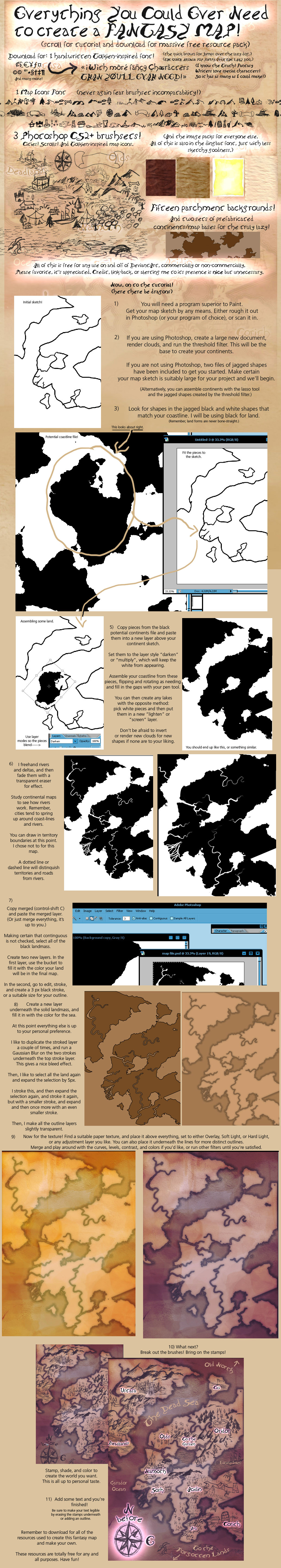
fav.me/d49xu2j Download this map tutorial + resource set of mine instead. It has a font and you can use it in all three programs. It'll also show you how to make a map in Photoshop, which can probably be duplicated in Paintshop Pro. Or use the image set to make brushes in Paintshop Pro. You can't use brushes in MS Paint or Animation Shop but you would be able to use the font included in the other download.
👍: 0 ⏩: 1
Thank you so much, but I can still only get to Step 6 where you're drawing the rivers and such. Oh well, it was worth a try, right?~ ;}
👍: 0 ⏩: 1
Well, you might have to be innovative, but I know for a fact Paint Shop can do all of the things that I did in that tutorial. I just no longer have it so I can't tell you how, you will just have to google for yourself to see how to select the black and make new layers, set the texture to overlay, etc.
👍: 0 ⏩: 0

leskaia.deviantart.com/art/Les…
👍: 0 ⏩: 0


")
Well, I can't argue with that. Glad they worked for you.
👍: 0 ⏩: 0

Awesome brushes!
Using the brush set to make a quick fantasy map for my students to use in creating their own culture! I hand drew the mountains, but the trees stopped me cold, and then I found your brushes, and I finished quickly thereafter.
Thanks for the amazing set.
👍: 0 ⏩: 1
Hey, that's a really cool use of the map set. Glad it worked for you!
👍: 0 ⏩: 0

Thanks a lot for posting this, I used it here: [link] It's pretty neat!
👍: 0 ⏩: 0

i used a few of these brushes here: [link]
thanks for uploading.
👍: 0 ⏩: 0

Been looking for something like this, thank you so much~!
👍: 0 ⏩: 0

This piece has been showcased in Spotlight Features - Volume 19
If you enjoy the article, please consider faving to support the artists within.
👍: 0 ⏩: 1
Cool, I don't think I've ever been featured by a random deviant before. ^_^
If you're into map resources, remember to check out my mega pack, it's way more awesome. [link]
👍: 0 ⏩: 1

| Next =>