HOME | DD
 Concavenator — Ea, part 4: Climate

#ea #geography #map #planet #speculativeevolution
Published: 2018-08-02 19:50:11 +0000 UTC; Views: 3722; Favourites: 32; Downloads: 0
Redirect to original
Description
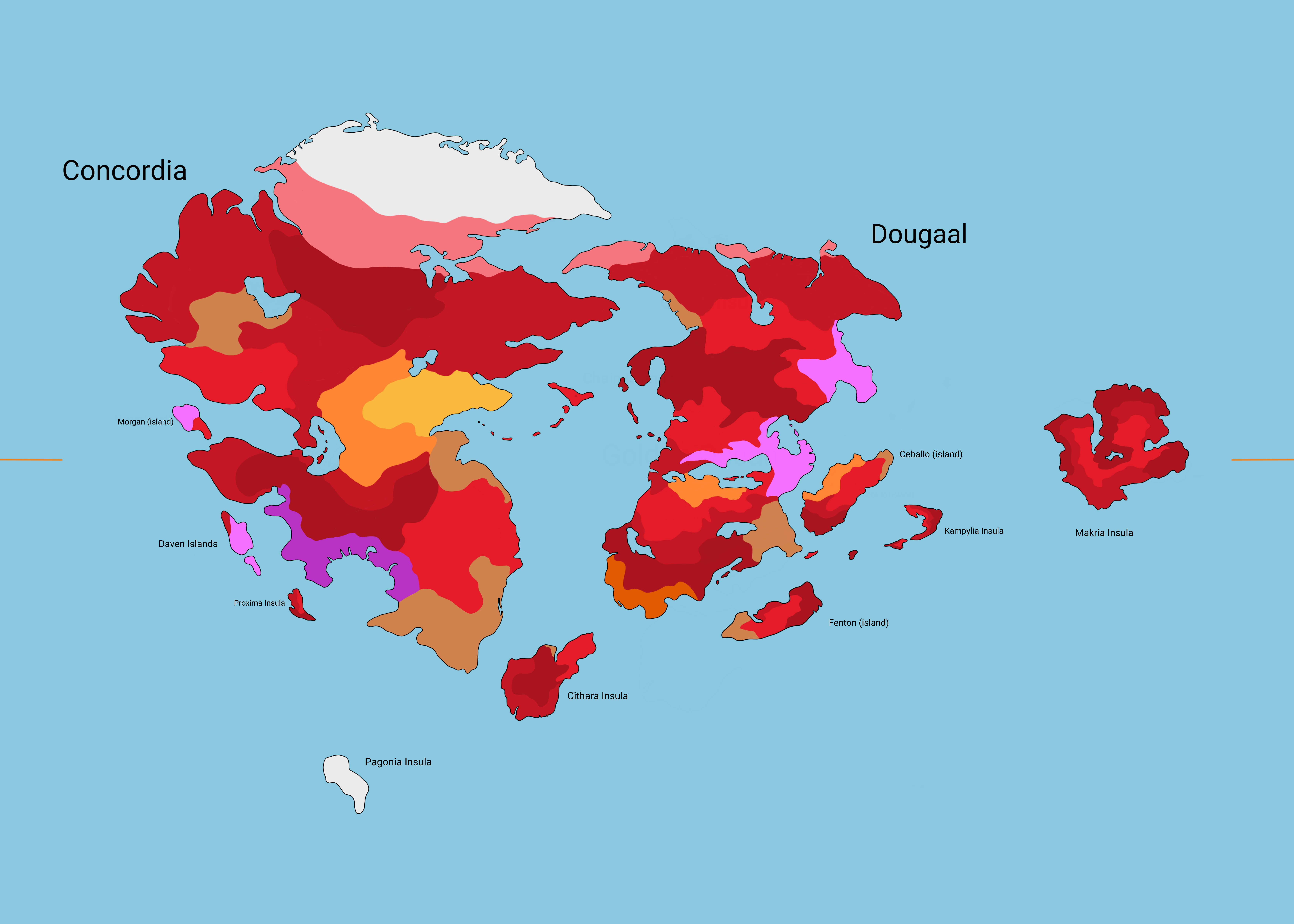
Once the geography and wind patterns are established, we can move on to the next stage.
Oceanic currents are largely driven by the wind, and thus move in the same directions, except where their path is blocked by continents. They tend to form large gyres relatively isolated from each other, trasferring heat from and to the continents with their movement between latitudes. On Earth, the classical example is the Gulf Stream, which warms Europe with tropical water; physics being the same on both worlds, the western edge of Dumuzi is in a similar situation. The southern edge of the continent is touched by a westward tropical current that keeps that region very warm year-long, and creates a small strip of rainforest at a latitude (30°N) where desert may be expected.
The classification of climates is based on a scheme devised by Wladimir Köppen in 1884.
Tropical climates are defined as having an average monthly temperature above 18°C all months of the year, plus heavy yearly precipitation. In pluvial tropical climates, clustered on the Equator, precipitations are distributed in all the year, while in seasonal tropical climates they are concentrated in a few months. The former encourages large, slow-growth vegetation with massive support structures, while the latter favors more annual species that lay dormant during the dry season and only grow during the rains. On Earth, this seasonal difference is due to the axial tilt changing the angle of sunlight over a year. Ea's axial tilt is only 8.5° as opposed to Earth's 23.4°, so that effect is much smaller; however, Ea's orbit is much more eccentric, meaning that its distance from the star Utu varies much more during an orbit. Seasonal variations are therefore independent from latitude, although the heavy equatorial winds still ensure that rain is always abundant at the lowest latitudes.
Desert climates are defined by a rather complex formula tying together precipitations and temperature, but the bottom line is that rain in scarce all the year. As said in part 3, deserts are found mostly around the 30° north and south latitudes, and in the rain-shadow of mountain ranges.
Temperate climates are defined as having the coldest month of the year between 0°C and 18°C, and all months being above 10°C. They cover a great variety of climates, ranging from a rainy subtropical on the east coast of Dumuzi to a mild oceanic climate with year-round rain its western coast, to a sort of dry-summer Mediterranean climate on southeastern Enlil, where the higher heat causes the southern air to sink and form a high-pressure region. Continental climates have a similar definition, except at least one month falls below 10°C of average temperature. They are typical of higher latitudes, but also of the interior of continents, such as the center of Dumuzi, away from the ocean's balancing influence.
Polar climates are defined as having all months of the year below 10°C. The include tundra and permanent ice, both near the poles and on mountains.
The Tropics are defined as the latitudes under which there is at least one day per year in which, at noon, the sun is at the zenith (i.e., directly overhead). At the Equator, this happens at noon every day of the year. Similarly, the Polar Circles are defined as the latitudes above which there is at least one day per year in which the center of the sun is above the horizon for 24 hours, and at least one in which it is below the horizon for 24 hours. (Since periods of time in which the sun is only halfway above the horizon are counted as "day", continuous daylight is slightly longer than continuous night.)
The latitude of the Tropics is always equal to the axial tilt, so in this case 8.5° N and 8.5° S. The latitude of the Polar Circle is the same latitude subtracted from 90°: in this case, 81.5° N and 81.5° S. Thus, the tropical and polar zones of Ea are much smaller than Earth's.
EDIT: changed a bit of terrain in northeast Inanna, added monsoons.
Other works in the sequence:
- Introduction
- Tectonic plates
- Continents, oceans, and mountain ranges
- Prevalent winds and patterns of rain
- Major toponyms
- Vegetation, coral reefs, and selected ecosystems
- Human presence
- UNSS Utnapishtim
- Earth in 2070
Related content


Comments: 5

👍: 0 ⏩: 1

👍: 1 ⏩: 0

I admire and envy your ability to apply recipes from the online "Climate Cookbook" (or something very similar) so comprehensively - quite frankly one would love to be able to do the same, but keep stumbling into my own laziness and tendency to distraction!
👍: 0 ⏩: 1
Why, thanks! Have you checked out Artifexian's worldbuilding series on YouTube? It's really good, very detailed, and digestible.
And yes, I sympathize with you  (Wink)")
👍: 0 ⏩: 1
Thank You most kindly for the suggestion and don't worry - one suspects that all Creative Types share your pain from time to time!
👍: 0 ⏩: 0