HOME | DD
 Kurarun — The Rest is Worthless
by-nc-sa
Kurarun — The Rest is Worthless
by-nc-sa

#afghanistan #alternate #cartography #history #india #jammu #kashmir #map #princely #state #allohistory
Published: 2014-11-16 23:51:08 +0000 UTC; Views: 23514; Favourites: 146; Downloads: 141
Redirect to original
Description
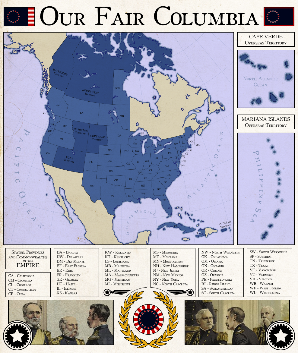
The decolonisation of India was a complex and chaotic affair - perhaps appropriately, considering the region had the size, population, and diversity (religious, ethnic, and political) of a continent. Though the simplistic "Two-Nation Theory" - by which India was considered to consist of two nations; one Hindu, one Muslim - was popular among Muslim Indians for a time, such an easy solution quickly proved to be impractical. The rise of groups such as the Pashtun Khudai Khidmatgar in the Northwest Frontier Province brought the theory's popularity to an end, as the KK and the various Muslim movements it inspired believed India was a multitude of nations based on ethnicity, rather than a pair based on religion. Though the All-India Muslim League, which believed strongly in the Two-Nation Theory, attempted to gain power by promising support for the British during WWII in return for recognition of the League as representing all Indian Muslims, this ploy failed due to their lack of support from large portions of the Muslim population and the impracticality of their ideal independent "Pakstan".The question of what to do with India's numerous, nominally sovereign Princely States was perhaps one of the simpler ones that faced British administrators. It was decided that they would have the option of joining a newly united India on their own terms once a united India had been established or remaining independent. It was the latter that the Maharajadhiraj of Kashmir and Jammu - Hari Singh - chose for his country. Rather than join with India, he hoped that his nation could remain neutral and independent; an Asian Switzerland nestled in the mountains of the Himalayas, prosperous and respected yet without affiliation or fear of war.
In order to attain such a status, Kashmir and Jammu was kept isolated - a hard thing to do in the midst of a Cold War, and stuck between the opposing juggernauts of India and China. Kashmir had almost no transport links to other countries, and international trade with Afghanistan and India was deliberately avoided in fear of drawing China's wrath (though Kashmir's approval of China's entry to the UN and the subsequent peaceful negotiations over disputed territory in Aksai Chin curtailed such fears somewhat). Relations between Kashmir and its neighbours was generally warm, but very limited, as it refused almost all political and economic association.
However, Kashmir's isolation helped preserve the state as a peaceful yet underdeveloped country during times when those around it underwent chaos and strife. Afghanistan, looking to throw its weight around after joining with the US, aided Turkic Muslim rebels in the USSR and China. India remained generally unaligned - save for its antagonistic relationship with China, with whom they had numerous border disputes, and numerous border skirmishes as a result - and later suffered as unrest among its Sikh population snowballed into a civil war, leaving India fractured, with a rump federation having lost much of its territory. Though political unrest in these newly independent countries would eventually begin India's reunification, Kashmir was glad to have been spared the chaos.
As the 21st century loomed ahead, the regional situation had been stable for quite a while, and without fear of invasion the people of Kashmir and Jammu were free to agitate for domestic reforms. The Kingdom gradually changed, with more and more power being devolved to democratic bodies, and franchise being extended across ethnicies, gender, class, and religious groups. The now modernised government of Kashmir now sought to modernise the country's economy. Being on generally good terms with its neighbours Kashmir was able to quickly expand their trading relationships with them, and by 2000 plans had been put in place to expand Kashmir's transport infrastructure and make several new international connections both by road and by rail.
Most of the population was concentrated in the south of the country, whereas the mountainous north was sparsely inhabited, therefore much of the development was concentrated in the south, being centred around the capital city of Srinagar. The short, simple railway line that ran though the capital was to be extended, covering a great deal of the densely populated south, connecting to Indian and Afghanistani rail networks, and providing the basis for further expansion with a line through the mountains to Kargil in Kashmir's hard to access northern areas. Roads were also to be expanded - or often just properly paved - providing ease of movement all throughout the country, as well as connecting to China along the Sênggê river in the East, and through the Khunjerab Pass in the north.
With its improving infrastructure and decreasing isolation Kashmir is on the verge of a great change, though the modern democratic government still maintains the country's now-traditional neutrality, entrenching the country's reputation as the Switzerland of Asia.
---
This is a map I made for round 108 of the Map of the Fortnight contest over on AlternateHistory.com.
First, I must note that this is alternate history - it is fiction - and no part of this description (which is written essentially "in-character") or the map itself is meant to criticise, condone, or condemn any ideology or nation, nor is it meant to have any specific bearing on real political issues, and I would encourage you not to discuss real issues surrounding Jammu and Kashmir in the comments. Corrections are still permitted, of course.
Anyway, I'm not sure what else there is to say really, except to note that the title comes from a quote by the Mughal Emperor Jahangir, who cherished the beauty of Srinagar and the Kashmir valley so dearly that on his death bed he is credited to have said: "Kashmir, the rest is worthless". Originally I planned to go with a longer quote by François Bernier - specifically "In truth, the kingdom surpasses in beauty all that my warmest imagination had anticipated." without "In truth" at the start, but that was too long for DeviantArt's title field.
Anyway, I hope you like it!
 (Smile)")
Related content


Comments: 26

This is really pretty! Is this modern time I'm guessing? Also really professional style
👍: 1 ⏩: 1

Thank you!
Yes, this is set roughly in the year 2000, before any of these infrastructure projects have been completed but after they've been planned.
👍: 1 ⏩: 1

At least the sikhs have a homeland to call their own.
👍: 0 ⏩: 1
Sorry, I'm not quite sure what you mean.
👍: 0 ⏩: 1
I mean that Jammu and Kashmir cover most of Punjab, which is the Sikh homeland.
👍: 1 ⏩: 1
Ah, it does cover part of it, but I don't think Kashmir and Jammu could be considered a Sikh homeland - I believe the vast majority of Sikhs live outside of its borders, and it's a majority Muslim country with traditionally Hindu rulers.
👍: 0 ⏩: 1

Nor Indian nor Pakistani. A good solution for Kashmir is the independence
👍: 1 ⏩: 0


I'd love to see a scenario where everyone is a swiss-esque utopian pacifist.
👍: 0 ⏩: 1

Interesting. This could have really happened. As I recall, India objected.
👍: 0 ⏩: 1
India did reject the Maharaja's offer to maintain the status quo, but I believe it was pro-Pakistan forces invading and taking control of various areas of the country that made independence truly nonviable for Kashmir and Jammu.
👍: 0 ⏩: 0

Oh God, your maps are so f*cking wonderful D:
👍: 0 ⏩: 1
Ahaha! Thank you! ")
Anyway, your maps are great too - certainly several orders of magnitude better than some of the crap I used to make!
👍: 0 ⏩: 1
I made some crap too 
Just look closer :0
👍: 0 ⏩: 1
Your stuff's not crap - it's distinctly good!
👍: 0 ⏩: 1
Thank you!
Yes I'm still alive, thankfully, I just don't make maps regularly any more (I have lots of other stuff to concentrate on, unfortunately).
👍: 0 ⏩: 1

you've inspired me my friend and I have created something as an homage to you fav.me/d86q9dr
👍: 0 ⏩: 1
That's awesome! Thank you!
By the way, I'm pretty well-versed in Inkscape by this point, so if you need any help with the program feel free to ask me.
👍: 0 ⏩: 1
yeah I'm just figuring out a lot about how to do basic stuff, only recently switched over to Inkscape. Definitely going to take you up on that offer sooner or later
👍: 0 ⏩: 0

Beautiful. Is it set in the same world as your Afghan and Turkestani maps?
👍: 0 ⏩: 1
Thank you! I think I neglected to say it in the description, but it is set in the same world as my Afghanistan, Idel-Ural, and Turkestan maps (though that Turkestan map is kinda non-canon now, since I realised there's a *lot* that could go differently in terms of how the countries are laid out). You can see the expanded Afghanistan in the West of this map, and I made mention of them being relatively powerful and a US ally in the description.
👍: 0 ⏩: 0