HOME | DD
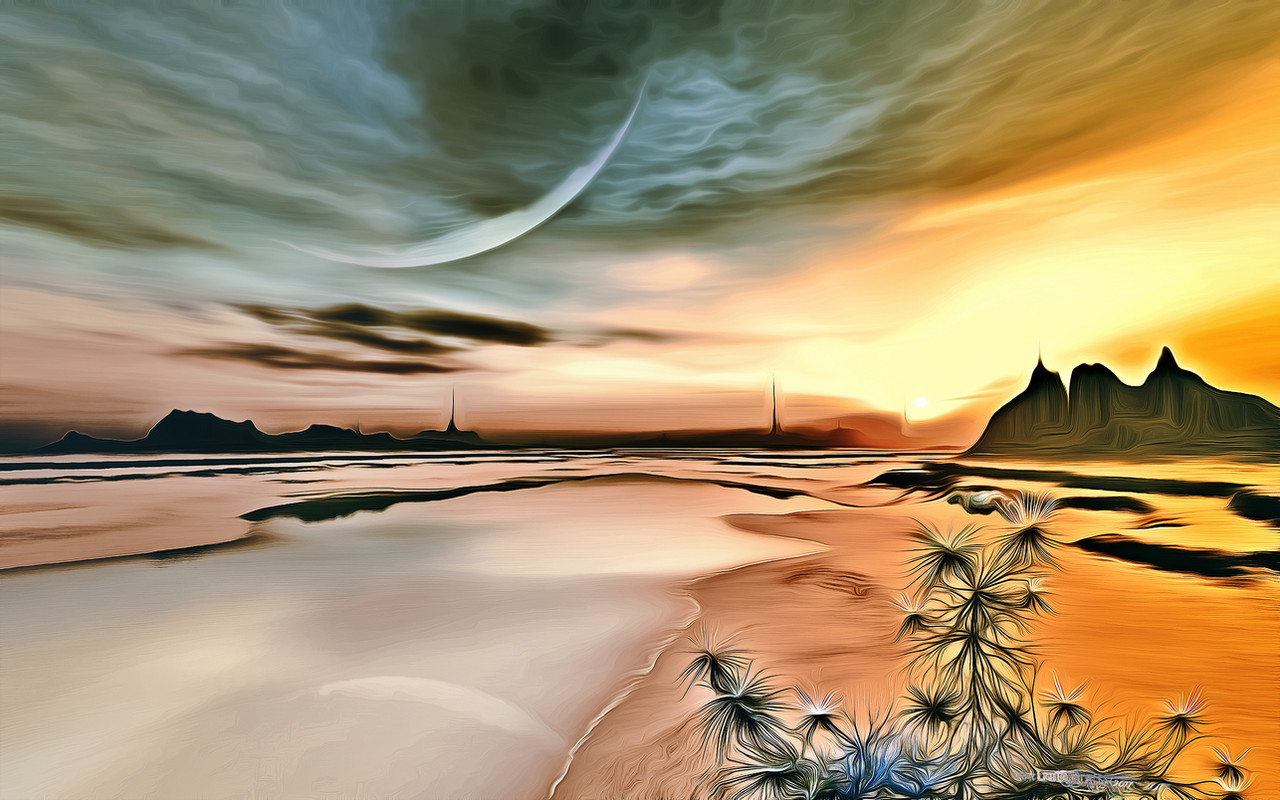
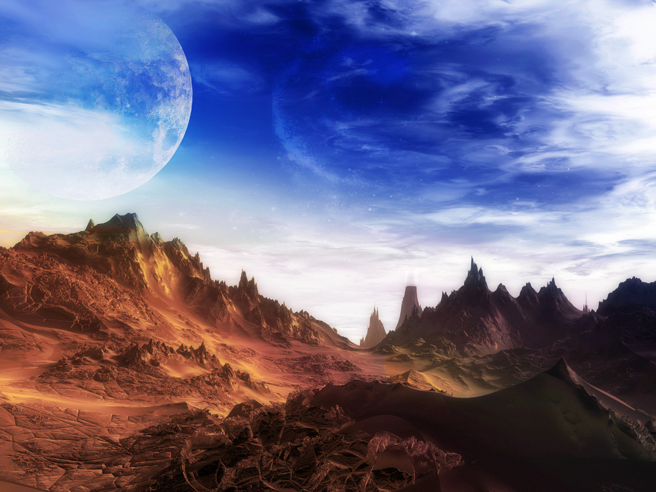
 LightDrop — Desert Spring

Published: 2011-05-07 17:03:44 +0000 UTC; Views: 4358; Favourites: 86; Downloads: 503
Redirect to original
Description
A render I did ~1 year ago, postworked in PS 2 months ago and finally digged out old PD Pro for adding some vegetation...Would like to hear what you think about the last - how could it be improved, what looks faked and so on...
Every comment on that veggie-thing is greatly appreciated!
Rendertime was 1 hr 50 mins, PW in PS ~45 mins, in PD Pro ~1 hr
T4V&Commenting!
Related content


Comments: 40

Yeah the vegitation doesn't seem to fit. Most of them look like they're just floating. They need to be smaller the farther away they are. They also don't appear to be castin shadows. The landscape looks really good thoug, i love the colors.
👍: 0 ⏩: 1

Thanks man! Finally a real feedback...
c u

👍: 0 ⏩: 0
Oh my Linda - thanks so much! Where have you been all the time?
c u
👍: 0 ⏩: 1

You're welcome, Chris! Oh, here, there..and back again.
 (Smile)")
👍: 0 ⏩: 0

Thanks lil sister - for the fave as well!
c u

👍: 0 ⏩: 1

Thanks man - glad you like it!
c u
👍: 0 ⏩: 0


Much thanks Elly - for the fave as well!
c u
👍: 0 ⏩: 0


The slope on the butte and mountains is a bit too steep to be believable, imo,
although I acknowledge that there are some pretty sharp formations in Madagascar: [link]
What 3D modeling program did you use?
How does one set up a landscape with a lot of close-up detail,
that recedes seamlessly to greater and greater distances?


👍: 0 ⏩: 1
I thinks you're right; but since this is imagined as an outer-space landscape, I think it's OK...
Tha render was done in Terragen 0.9 the terrain in GeoControl V2, postwork in Photoshop CS 5 and in Project Dogwaffle Pro V 3.5, where I did the veggies; I think those give the impression of close-up detail while the landscape is mostly as rendered in TG - beside some color- and level-correction done in PS...
HTH
c u

👍: 0 ⏩: 1
Wooff! That’s a lot of tools!
What I have is Bryce 7, Carrara 8 Pro, DAZ Studio, Blender, and, recently, Vue Frontier
(GIMP and Inkscape, also); but I have yet to figure out how to do a landscape like yours,
that has a detailed foreground, and then seamlessly recedes into the distance:
especially because I’d like to base my scenery on grayscale maps like this one
(which I can zoom in to about 10m per pixel at native scale).
Anyway, your steepness of slope is not really a problem:
there are famous buttes in Arizona whose walls are even steeper!
👍: 0 ⏩: 1
I had a look to your grayscale-map and it's the very same kind you could use in Terragen, which you can download here -> [link]
That's a free version which is limited to 513x513 terrains and a max-size of renders of 1280x960...
Terrains on the other hand, which are also for Vue, Carrara, Bryce and a lot more of apps, you can create in GeoControl2; you can get a 30-day-unlimited-working version for free here -> [link] (maybe this link will bring you to the German site; if so click on the British-Flag for an English version) On the forums there are some Tutorial-Videos available and more advice...
I can't give much help in Carrara or Vue since I just played around a bit with both, but if you should like TG (the classic-version) I could give you a lot of tips...
HTH
👍: 0 ⏩: 1
The free version of Terragen: yes, I did download that, once,
but was turned off by the 513 restriction.
Then DAZ briefly offered Vue Frontier for about 50 dollars,
so I went for that, and have actually played with it.
GeoControl is sold, oddly enough, by the same company,
and it seems like a great tool for defining terrains,
but if I already have grayscale maps that I can make mutually consistent,
then maybe I can skip the GeoControl step, yes? No?
What still confounds me, though, is how best to do a hierarchy.
How do I seamlessly meld a high-polygon foreground to progressively
lower-resolution scenery, receding?
My conundrum is in terms of model definition:
I'd love to have my 3D model set up that way, not just the final render.
👍: 0 ⏩: 0

Thanks! I'm glad you do so.
c u
")
👍: 0 ⏩: 0

 (Wink)")


Wonderful...I wish this was an actual place so I could go there.
👍: 0 ⏩: 1
I wish that too. Thank you!
c u
👍: 0 ⏩: 0

Much thanks - glad you like it!
c u
👍: 0 ⏩: 1


