HOME | DD
 Sharklord1 — (Colored) World Map 1942
by-nd
Sharklord1 — (Colored) World Map 1942
by-nd

#map #maps #historical #history #nazi #nazigermany #soviet #sovietunion #unitedstatesofamerica #worldwar #worldwar2 #worldwarii #worldwartwo #ww2 #wwii #imperialjapanesenavy #historymap #mapsandflags #historicalmap
Published: 2018-02-02 04:01:34 +0000 UTC; Views: 33459; Favourites: 83; Downloads: 482
Redirect to original
Description
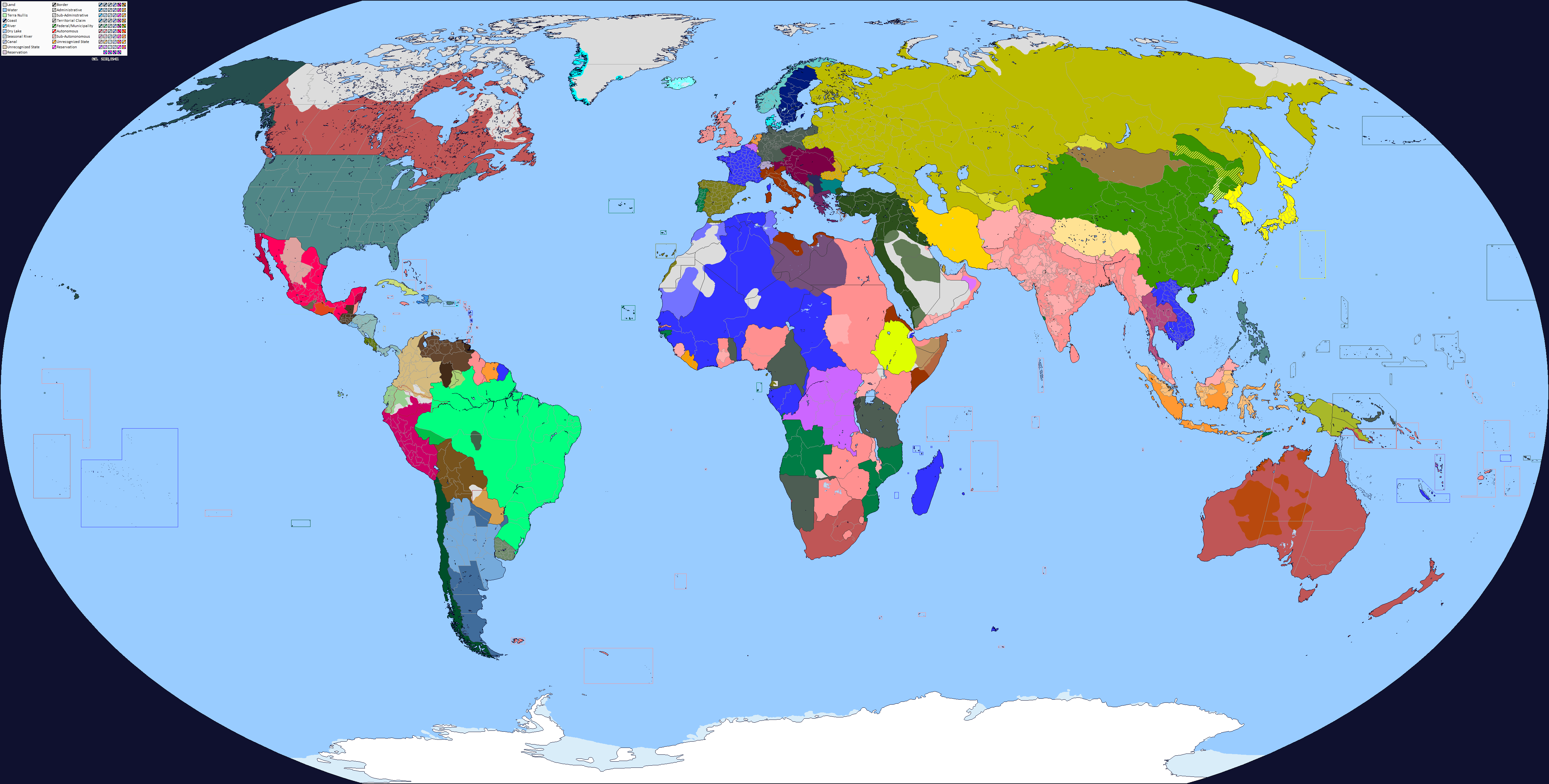
I've taken a lot of time to produce this map, which I think I've done a pretty good job at.This is a map of late 1942, during the height of the axis powers invasions across the world. I've added in several first-level administrative boundaries that are not often seen on other q-bam maps.
If you have any questions about said map, please ask; as for corrections, tell me them so this thing can be improved; if you have a q-bam of a certain area of administrative boundaries that were not previously on this map, please tell me. This map, I want, to have it achieve a final version so that it can be used and easily navigated.
Special thanks to
for the unintentionally inspiration to create this
for his map of pre-ww2 borders that helped develop a vast majority of administrative boundaries dinospain.deviantart.com/art/T…
and for whoever made the original 1942 q-bam www.alternatehistory.com/forum…
Blank Version: sharklord1.deviantart.com/art/…
Related content


Comments: 24

👍: 0 ⏩: 1

👍: 0 ⏩: 1
👍: 1 ⏩: 0

👍: 1 ⏩: 0
👍: 0 ⏩: 0

👍: 0 ⏩: 0

👍: 0 ⏩: 0

Mauritius is shown as under French control, when it was actually under British control (from the 19th century until its independence in 1968).
👍: 0 ⏩: 0

There is a little error in Mexico.
Yucatan appears as if it were territory when at that time it was already a state. The territory that should be colored as such is Quintana Roo.
👍: 0 ⏩: 0


Nice map but Soviet internal borders is incorrect - The USSR experienced many small administrative reforms that were associated with the creation of new regions in the 1930-40s.
👍: 0 ⏩: 1
For example, the ASSR of the Volga Germans was liquidated in July 1941. I plan to make a series of maps of the administrative division of the USSR from 1930 to 1991
👍: 0 ⏩: 1

Really good map of 1942 QBAM. Hope you do 1946 world map
")
👍: 0 ⏩: 1
Perhaps. I’ll have to finish the 1945 first
👍: 0 ⏩: 1

Thanks for mAking this do you take requests
👍: 0 ⏩: 1
Depends on the request
👍: 0 ⏩: 0

Wow, I didn't expect you tagged me. What did I grant you?
👍: 0 ⏩: 1
Inspiration, since you and a few others often do alt-history ww2 scenarios. I was looking to do my own alt-history ww2 maps and I don't really like the older ww2 map to help give me a head-start. So I made this map
👍: 0 ⏩: 1
Now I understand what you are talking about.
👍: 0 ⏩: 1