HOME | DD
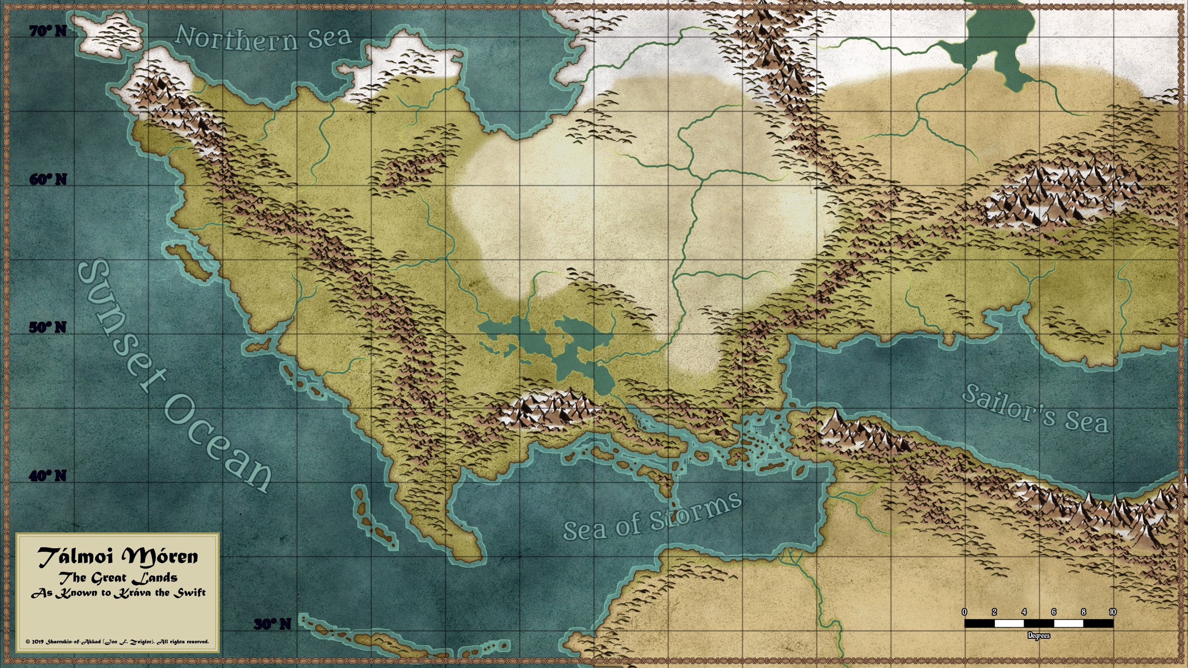
 Sharrukin-of-Akkad — Revised Talmoi Moren Continent Map
#conlang #fantasy #map #curseofsteel
Published: 2019-10-16 21:40:27 +0000 UTC; Views: 5105; Favourites: 86; Downloads: 16
Redirect to original
Description
I'm in the process of writing a swords & sorcery fantasy novel, with the working title of The Curse of Steel. This project has been lurking in the back of my mind for quite a while - here's a setting map associated with a very early version of the idea:More recently, I've managed to finally get the world-building organized to my own satisfaction, and the first draft of the novel has just passed the half-finished point (about 60 kilowords out of a planned 120). I'm no longer thinking in terms of an alternate-historical Earth - now the setting is a fully alternate world, taking inspiration from Robert Howard, Fritz Leiber, and (oddly enough) J. R. R. Tolkien.
Up until recently, my map-making workflow relied almost entirely on Photoshop. Now, while Photoshop is a robust and full-featured tool, it can be excruciatingly tedious to build a fantasy map from scratch with it. A few days ago, I picked up a new tool called Wonderdraft. This isn't nearly as full-featured as Photoshop, but it is nicely optimized for the production of pretty fantasy maps. This map is my first effort with it, and I am very pleased. Whereas the 2017 map took me at least 25 hours of work - most of that laboriously placing mountain, hill, and tree icons on the map one at a time - this map took me less than 8 hours total and is much prettier. I think I have a new workflow for this piece of the creative process!
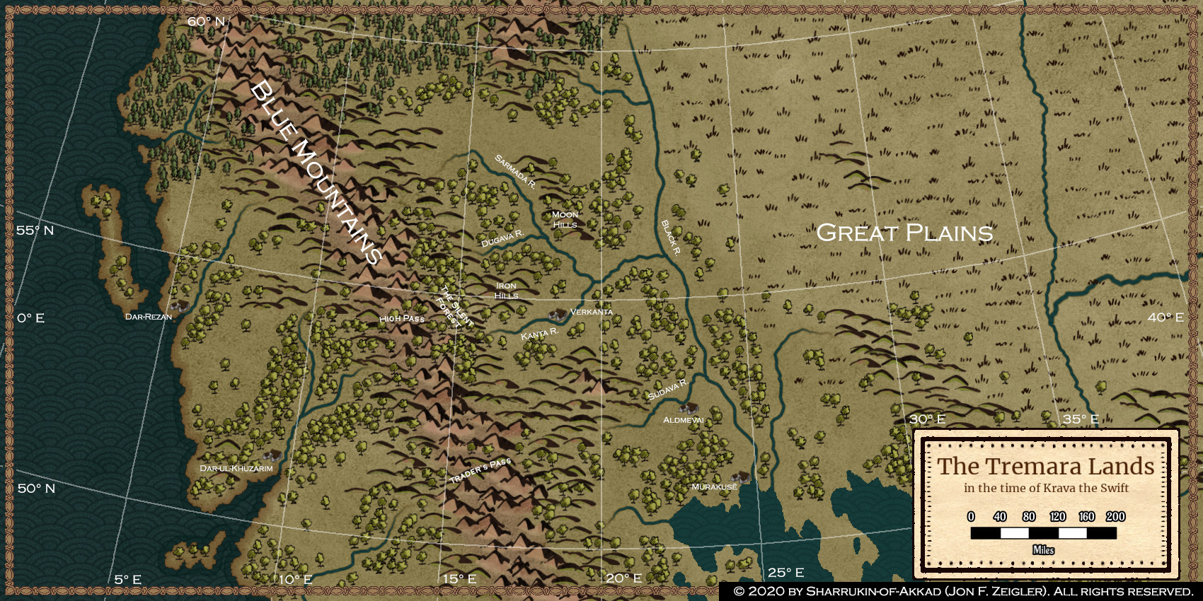
Plan is to use this map as the base reference map for the whole setting. I'll probably zoom in on specific areas and use Wonderdraft to construct regional maps so I can keep things straight while writing. If the project ever really takes off, I suppose some of those may end up in the book itself!
Technical notes: this map is in equirectangular projection, where north-south and east-west distances are always the same distance on the map per degree of latitude or longitude. (Technically, the projection is plate carrée, since the standard parallel is on the equator). The area covered is roughly equivalent to Eurasia from the Atlantic past the Ural Mountains, along with North Africa, although obviously the continental configuration is different in this world.
I used Photoshop to compose two map images, this one:
. . . and a much-manipulated map of southern Europe and the Middle East, to help fill in the details on the southeast quadrant. (The manipulation of that image was done in Photoshop too, but that was just scratch-pad work, not to be posted here.)
Once that was done, I created a new Wonderdraft project, imported the composite image as an overlay for tracing, and went to town. All assets were from the standard Wonderdraft libraries, as of version 1.1.0 of the software. All but the text box in the lower left was produced in Wonderdraft - the text box was produced in Photoshop CC.
© 2019 by Sharrukin-of-Akkad (Jon F. Zeigler). All rights reserved. You may not copy, alter, or repost this work without my express written permission, nor may you in any other way treat this work as your own.