HOME | DD
 Tapejara — Toci1 Map 2
Published: 2012-11-22 03:14:25 +0000 UTC; Views: 983; Favourites: 10; Downloads: 5
Redirect to original
Description
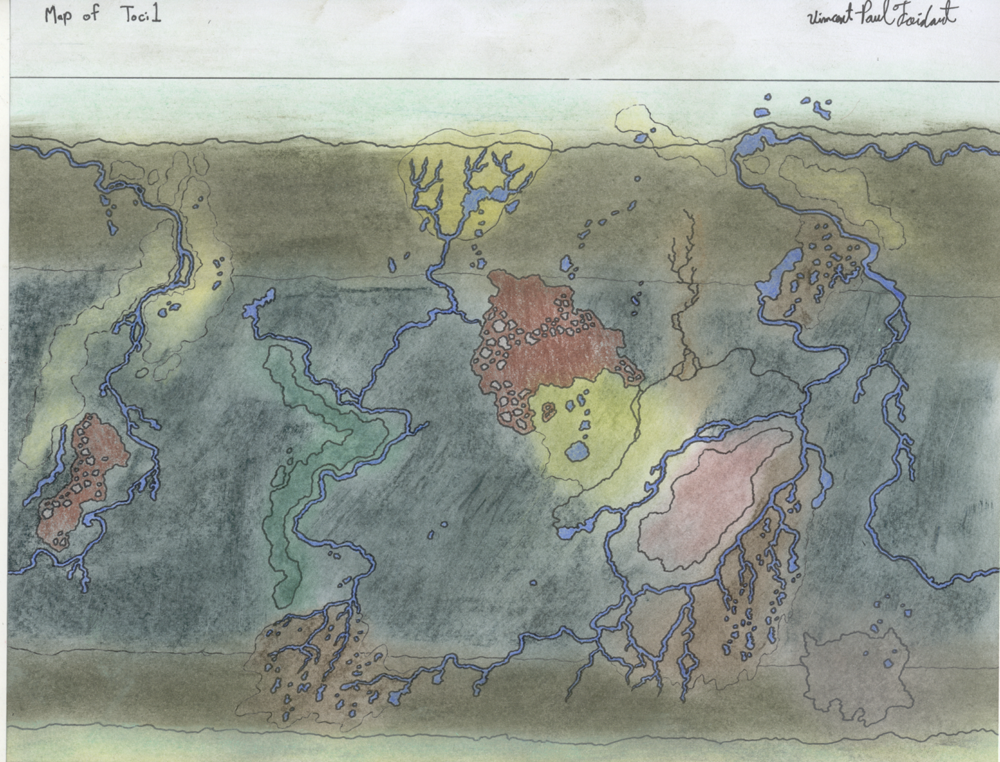
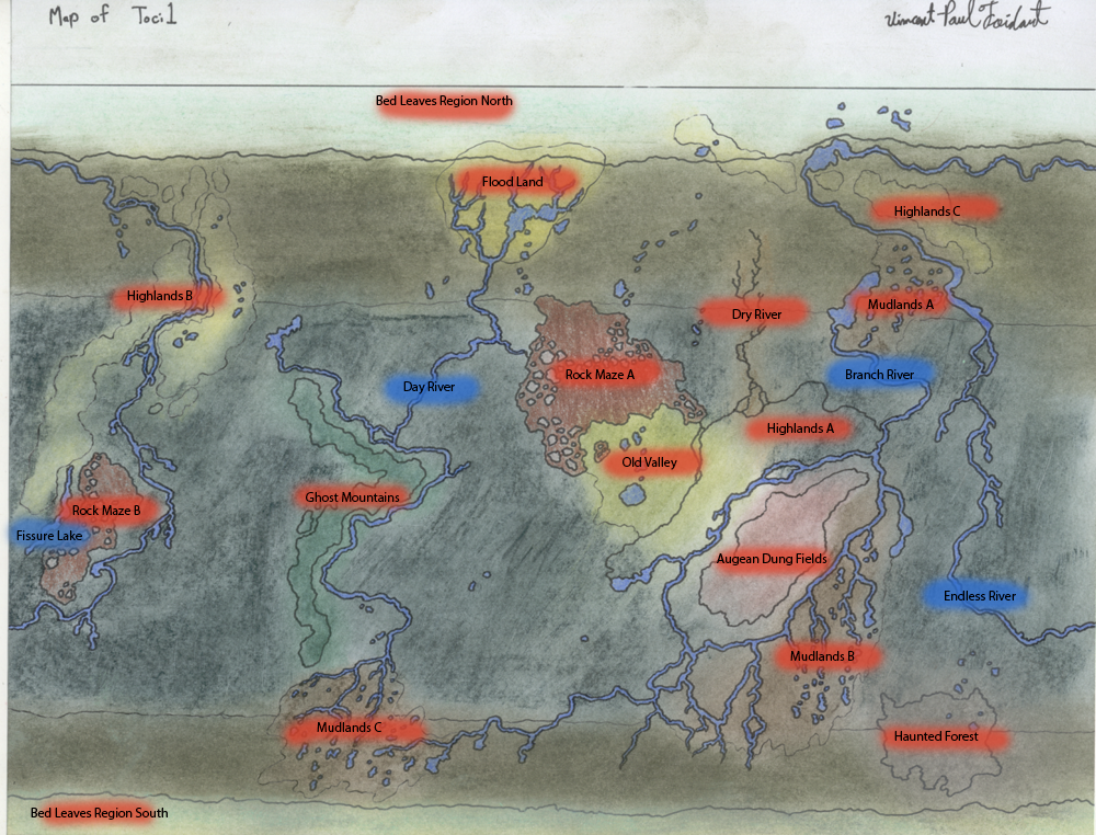
Another version of the map with tags to indicate the title of the different regions. Just like the animals of the planet, the names of the regions are relatively straight forward.The Bed Leaves Regions are located at the poles of Toci1 and are specialised forests rather than ice caps. The forests are made of giant rhubarb like trees that can support large animals with their larges leaves. The plants there can survive with limited sunlight and get most of their nutrients from the minerals drifted from the rivers.
The Floodland is a giant swamp north of Day River where precipitation is most abundant. The region regularly floods, hence the name, and most animals are semi-aquatic. This region serves as a filter for the waters of the planet.
Day River is named so as it is for the most part situated where days are said to begin on Toci1.
The Rock Mazes are the remains of ancient mountains and caverns. Overtime, precipitation and acids from plants have erroded away most of the rocks, turning the landscape into a valley of rock columns and water falls.
Unlike Rock Maze A, Old Valley has not changed much overtime. It still collects some of the waters of nearby rivers into lakes, which forms water falls in the Rock Maze up north when the lakes overflow. The trees here are relatively short since sunlight was originally limited due to the mountain shade.
Other remnants of the mountains are the highlands which are now simply a series of large hills. These mountains have completely errored and have been covered with tons of humus over the years. Animals have to cope with living at a slight angle. Lakes are rare in these regions.
More impressive yet are the Ghost Mountains, or what's left of them. Eons ago, they were dominated by tough vines that crawled all over the rock faces. As the rocks eroded, the plants simply supported themselves and created their own ecosystem. The result is a giant skeleton shaped like the former mountains, created by an array of these vines. Some portions of the region are supported by plants that evolved hydrogen bags.
Branch River is named after the many deltas it creates. Some of its waters merge with Day River. The Mudlands as unstable regions of over saturated soil maintained damp by the constant flow of rivers. Careless animals can sink through the mud but will survive if they cross it by crawling like snakes. Even worst are the Augean Dung Fields. This region has expanded over the years and became a valley covered by an entire manure field 3 metres deep. The stench there is horrid and few plants and animals (mostly parasites) can survive the conditions. The region was created by a single creature that defended themselves from predators by smearing themselves in their own feces. The area is limited by nearby rivers that carry away over exceding filth.
Fissure Lake is the deepest lake on Toci1. It is nearly as deep as the Pacific Ocean on Earth.
Endless River is unique. It is a river fed by lakes and rainfall that never ends. It loops around a third of Toci1's face. Since most of it is actually salt water, the plants and animals it supports are unique.
Finally, the Haunted Woods are a poorly explored region of Toci1. It was set to be explored further but strange occurences that cannot be explained by science has halted further explorations. It is said that paranormal activities has ended the lives of several explorers. Even the native Gorgosapiens seem to avoid this region. If this is true, then Toci1, one of the world that is meant to explore the possibilities of alien life, may for the most part be a source of interest to those meaning to explain paranormal activity. In short, it is Toci1's equivalent of Earth's Bermuda Triangle.
Globe view: fav.me/d2wb5mv
Without tags: tapejara.deviantart.com/art/To…