HOME | DD
 vorropohaiah — ATLAS ELYDEN - #10: a map of Vaalk

#cartography #fantasycartography #fantasymap #map #worldbuilding #elyden #atlaselyden #vorropohaiah
Published: 2016-07-03 05:25:24 +0000 UTC; Views: 6782; Favourites: 82; Downloads: 85
Redirect to original
Description
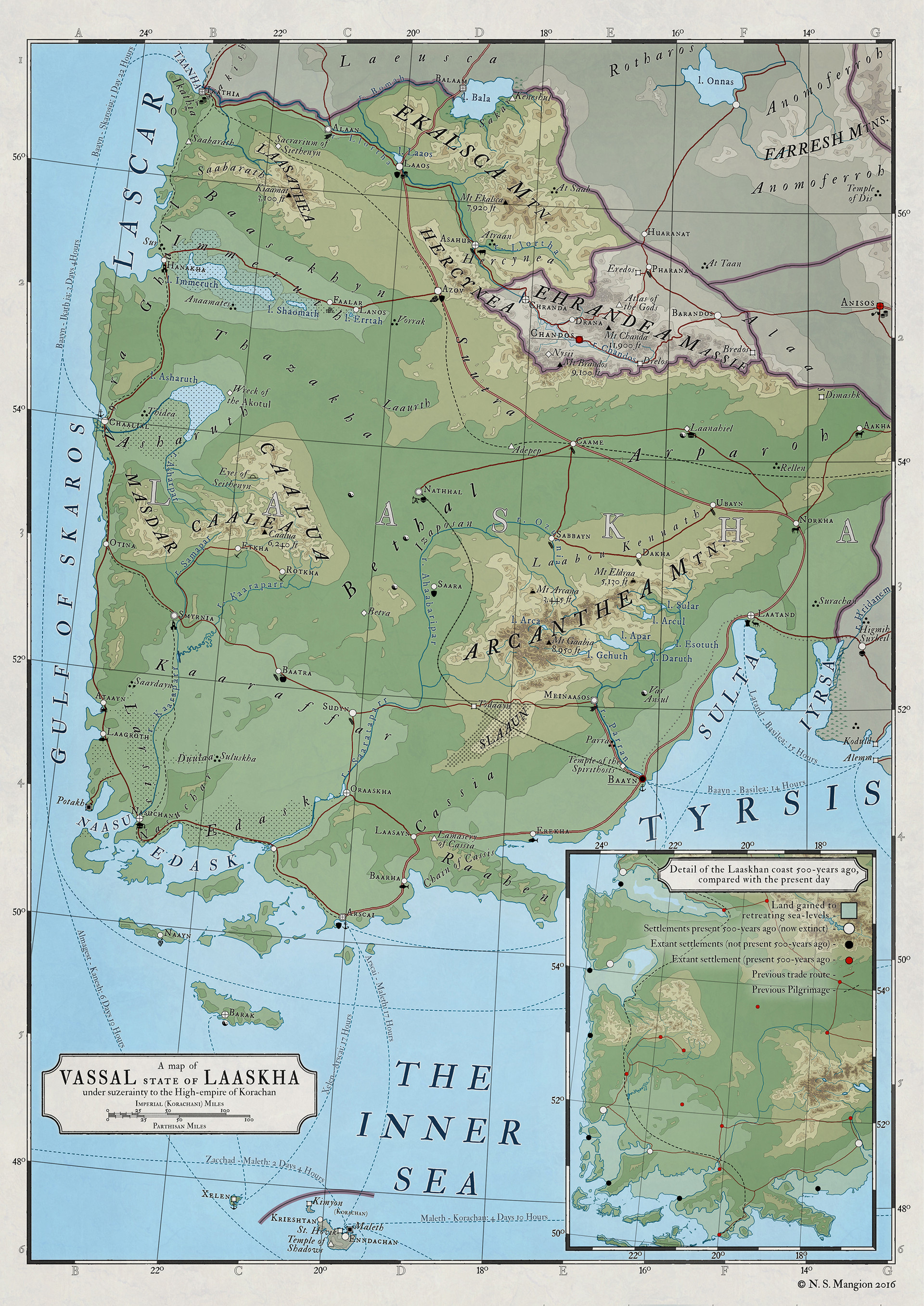
this one was done relatively quickly - the topography and most of the labels were already done thanks top my older maps, and it was a relatively small land area to work with. The large empty space in the top right corner will likely be filled in with something informative (maybe a city map of the capital or a zoomed-in version of somewhere else, not sure yet).C&C are more than welcome, and remember, you can follow my patreon for high-res maps, textless maps, more details on the world and other exclusive content , thanks
 (Smile)")
A key/legend to the map can be found here
__________________________________________________
“At the end of all things there will remain only one. When the seas are gone and the land is dust and death, one being will be left, observing. As Elyden dies He judges the actions of those who perish. He is the Knower. He is the keeper of tales, the rememberer of histories, the crux of all knowledge.”
- Vaalkan Legend
The Knower is more than national folklore, he is the closest thing the people of Vaalk have to a religion. He is such a part of everyday life that people justify their actions by thinking how the Knower will judge them. “By his actions will the Knower Judge him,” is a common grave quote.
Vaalk was once a Korachani territory, though following the Sundering of the empire in 3705 RM the empire lost most of its southern territories to the Reformed empire of Sarastro. Vaalk, whose loyalty to the Archpotentate Malichar (ruler of the Korachani empire) was absolute, resisted Sarastroan takeover and fought against his forces for 31 years before being finally defeated. Worship of the undying machine was, which was never strong, slowly died, and was replaced with a more fervent worship of the Knower. It remains now as a martial territory and its armies still look to Malichar as a patron.
* * *
Related content


Comments: 3

I followed your tutorial and I have a question. I understood your explanation with the mask layer and the lasso-tool ect... but how did you make the dark blue outline of the landmass? Did you just re-trace it after you revealed the landmass with the lasso-tool?
Other than that is is a well looking map. ")
Where do you get your inspiration for different landmasses?
👍: 0 ⏩: 1

Hi, if you mean the outline between the land and see, I apply an inner 2 px blue stroke to the land layer. Hope I answered the question!
I read a lot of atlases at different scales to get a feel for realistic coastlines. Most coastlines are done without much though, though a few - like Korachan and Hololach are made to evoke a real-world feel (Italy and Scandinavia, respectively)
👍: 0 ⏩: 0
