HOME | DD
 Built4ever — Castles and Villages Area Map

#castles #map #pencil #sketch #villages
Published: 2018-09-15 20:51:14 +0000 UTC; Views: 14805; Favourites: 324; Downloads: 0
Redirect to original
Description
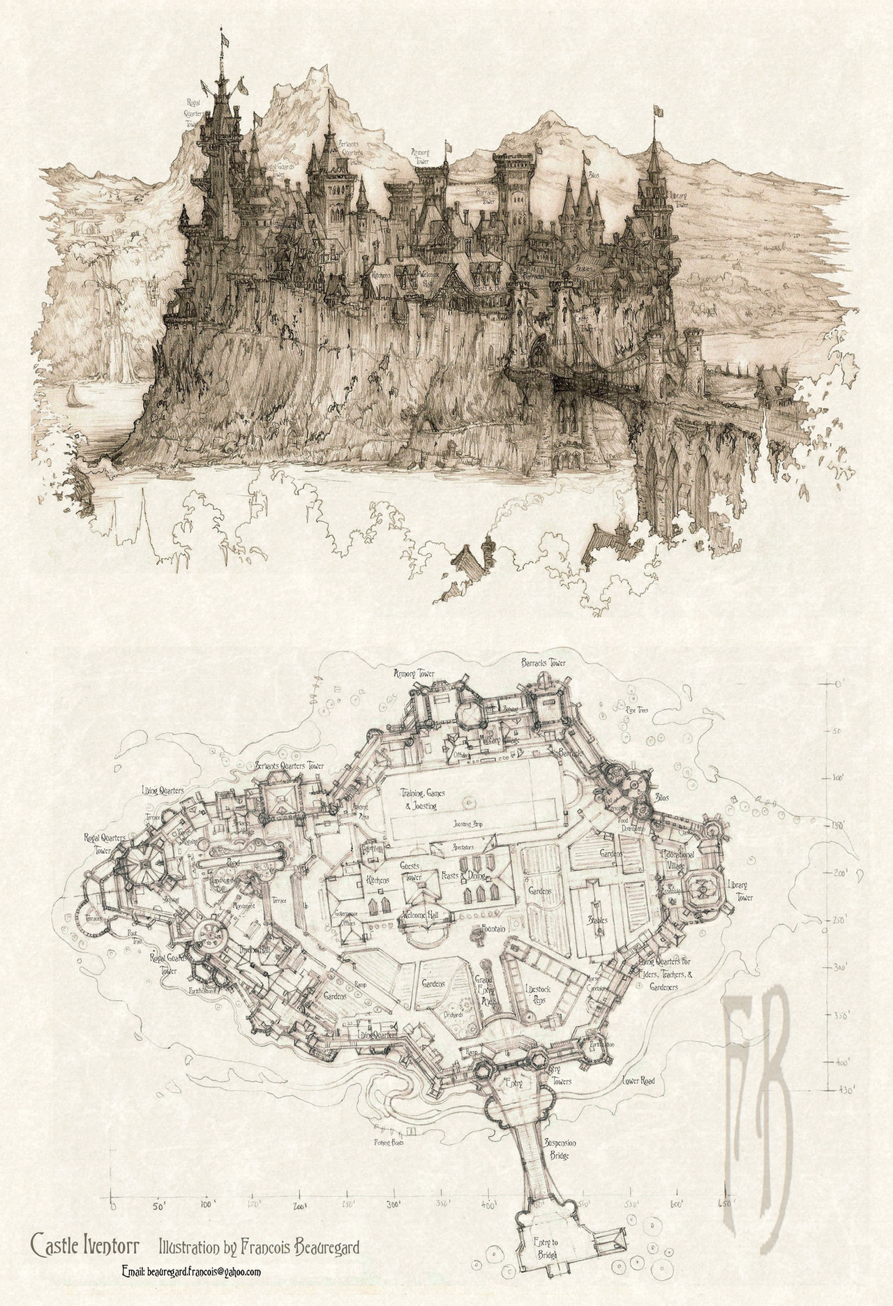
My first shot at trying to put the numerous castles and villages I've drawn into a "larger picture" context, including drawing a map of an imaginary region with some of the locations of the castles, mountain ranges, lakes, rivers, roads, bridges, waterfalls, important road junctions, and more. This is really the first time I try this. There's plenty of guys on Deviantart who draw fabulous maps. There's lots to learn, especially regarding proper scale and distances which reflect the view depicted in the stuff I drew. For example, looking at Castle Two, how far away are the mountain ranges? Is my map accurate or are the mountains too close? Road networks have to be scrutinized. Everything has to named! Lots of stuff to consider. But it ties together to numerous castle-village illustrations from the last 5 yrs or more. NOW we can see that the village of Amblewood is really just a short ways down the same valley as Cascadium! SO it all starts to come together.Also relevant and important, discussed last week a bit in a journal entry, is to decide on a tech level for your civilization. What I choose appears to exclude modern cars, BUT it could allow a little steampunk train running through the valleys and along the lake shore! (hint hint)
Also, there are OTHER castle-villages, road junctions, hamlets and such that are already drawn but will ONLY be available to see when you purchase the book, so they will not be shown here on Deviantart.
Finally, a note about purpose of this enterprise: these illustrations and maps, all wrapped up into a collection in a volume, could serve many purposes, including as part of a greater narrative/story, used for a RPG or other game system, as a source book for various architectural concepts and examples, and more.
Feel free to critique, this map will be modifed and added onto extensively, so if I have big problems on it to correct, NOW is the time to do it before I box myself in!
Note: File was updated on 9-16-2018 Morning.
Related content


Comments: 32

👍: 0 ⏩: 0

It could just be my childhood nostalgia speaking, but your art reminds me a hell of a lot of the Dutch themepark De Efteling. Are you already aware of it? If not, you might get a kick out of some of their stuff.
www.google.com/search?tbm=isch…
www.pinterest.com/search/pins/…
👍: 0 ⏩: 1

Interesting, thanks, yes, never saw that before, and it does look a bit like my stuff, especially the storefront studies. Funny thing is, in Europe, you really don't need a theme park to "simulate" idealized villages and towns when the real deal is scattered all over continent. Mostly Americans build 'em because we don't have that here.
👍: 0 ⏩: 0

I'm glad to see that you are bringing these together into a larger cohesive project.
I'm sure it will prove interesting, as all your work is.
Definitely determine your scale of miles/measurement early so things stay consistent.
It helps a lot to have that at the early stage. I'm sure you are already doing that.
I like to check real world distances and sizes for things to get an accurate idea, though those numbers can change for a fantastic setting.
Let us know when this book is available. I know i'd be interested in a copy.
👍: 0 ⏩: 2
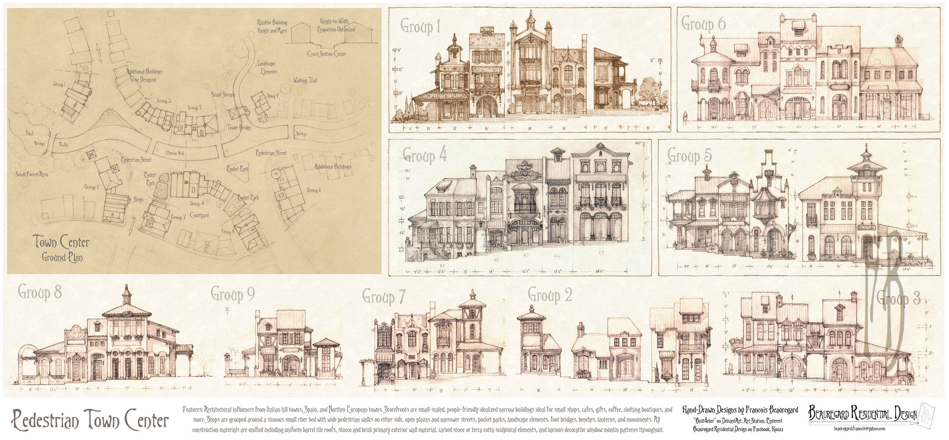
Also, just posted this one, a town map, which might end up as a town on the main regional map above:
👍: 0 ⏩: 0
Sure thing. Yes, I keep double-checking everything from street widths to topographical slope to block size and lot size, on and on. Makes a huge difference if the tech level supports cars and trucks, or not. Streets and alleys in Medieval europe were ridiculously narrow by American standards. From an architectural design/town design standpoint, in reality (not fantasy,) my biggest influence is DPZ, Duany/Plater-Zyberk in Miami, town planners extraordinaire. They have everything codified from biggest ideas (how many acres necessary to build a nice small town with a walkable downtown?) to street and lot sizes, corner radius, building height, on and on. In YOUR world this stuff is not so important, but unity of design, cohesiveness, a good storyline, and lots of other stuff IS. I'm trying to "get on your turf" a bit and develop mild storylines, possible character types, transportation systems, local agriculture, and more, that fleshes out a town.
Your stuff has improved tremendously in 5 years, that's why you're getting commissions and work. My task is to bring together the individual architectural designs, houses, shops, castles, whatever, and unify it all into towns, regions, and worlds. Working on it!
And if you ever put a self-published book out, I want one too.
👍: 0 ⏩: 0
Thanks Pat! Checked your stuff too, very nice comic illustration, with a beautiful flair and style that is easy to identify. You know, I'm French-Canadian guy basically? SO I was raised with Tintin and Asterix, probably you too.
👍: 0 ⏩: 1

Merci bien!
Oui, j'ai grandi avec Tintin, Astérix et Lucky Luke. Je recevais aussi beaucoup de «Comics» Marvel traduits en français (Éditions Héritage au Québec). Cet amalgame fait souvent dire à mes éditeurs (Français) que j'ai une mise en scène Franco-Belge avec un style de dessin «American Comic Book».
Je tiens à te le redire (...en français): Ton travail est superbe!
👍: 0 ⏩: 1
Oui je prefere Franco-Belge "Euro" style, aussi Mobius et Francois Schuiten et plus...
👍: 0 ⏩: 0

omg. I admire your patience to draw this many details....
👍: 0 ⏩: 1
Yeah those are many different projects drawn at different times, and all brought together, so it represents stuff from several years basically.
👍: 0 ⏩: 1
But still, claps to your determination, patience, and skills.
👍: 0 ⏩: 0


I'd still like to know when I can move in ")
👍: 0 ⏩: 1
Thanks! Yes, I'm complicating my life a bit with this next step he he he... feel free to start packing and hire a moving truck, I'll find you a house...
👍: 0 ⏩: 0

Map was updated with some of the various castles and villages, on 9-16-2018 11AM. Just to keep a note in the comment stream.
👍: 0 ⏩: 0

if you need inspiration for mapmaking try and contact this artist, , he gave me tips in the past and has some generally stunning map art, examples below:
map example:
map legend:
one of his city plans:
your map here is very sketchy and obviously scanned in which is making the details pretty hard to make out, but for a first draft it doesn't look too shabby at all
 (Smile)")
i'd recommend getting your height-map and legend done properly so your terrain can be used as a solid foundation, then add "manmade" keypoints such as castles, villages, cities and important areas, after this the roads, tunnels and bridges followed by various secondary points of interest where needed.
good luck in your endeavor, mapmaking is quite the undertaking and after getting a good amount of information certainly nor for the faint of heart especially if you want it to look right
👍: 0 ⏩: 2
Yeah I looked at your maps, very detailed, concise, with legends that include animal life and mineral geography! That's super detailed, maybe beyond the scope of what I myself am trying to do. Otherwise, your maps look "professional" almost as if you were actually a map maker for real-world maps. Maybe you are! Most likely I will stick to hand-drawn, possibly watercolored, for the final map that I will eventually do.
👍: 0 ⏩: 1

your maps are great. i get an old school warhammer fantasy roleplay vibe from them, which i really like. keep up the good work
👍: 0 ⏩: 1
Yeah thanks, and this one here will get re-done much more detailed and better quality, this is just a starter sketch! Check back, I'll be switching this file out a few times in the future, it should get better. Of course, my emphasis is really on the architectural aspects, I'm just "learning" the map-making skills slowly.
👍: 0 ⏩: 0

Wow, you have no clue about Built4ever's work here right?
Maybe look through his work before you become the "great map critique".
As far as I see this is a scetch to put the different settlements and also their drawn backgrounds into the context of a map. The map is drawn to provide the terrain shown on the drawings. It is an obvious sketch.
👍: 0 ⏩: 1
before you try and attack me here, i did say it was a scanned in sketch, possibly a first draft at that as in the OP he states "My first shot ... This really the first time I try this...", i did in no way mean my comment as a critique nor did i try to make it as such, it would be very different if it was.
all i did here was offer a reliable experienced map-making contact (with some examples of his work) who Built4ever can try to contact and ask for help if he wants to do so and if he wants advice on how to make maps properly, to an extent, as i know firsthand that making a map is complex, no joke and requires extensive knowledge to properly do the terrain, map scaling, orthographic projection aka perspective (depends on map size and scale), water features, heightmaps, roads, points of interest, etc., etc.
Built4ever is a wonderful artist with great art who clearly states what this map is intended for and as you said, it's to provide a setting for his creations in map form, i don't see how me providing a possible great source of help and information is a bad thing really...
👍: 0 ⏩: 1
Alright everybody cool off. No problems. Yes, this is very rough sketch to check relative distance. What's the scale of the map? How far are the mountains? Do they match up with what you see on the original castle sketch? Those are the kinds of things I'll check before I re-draw this as a more detailed map.
👍: 0 ⏩: 1
have fun and good luck, looking forward to updates on this map
👍: 0 ⏩: 0