HOME | DD
 MrJmZack — Hyrule Ultima

Published: 2012-01-23 17:38:18 +0000 UTC; Views: 8108; Favourites: 68; Downloads: 493
Redirect to original
Description
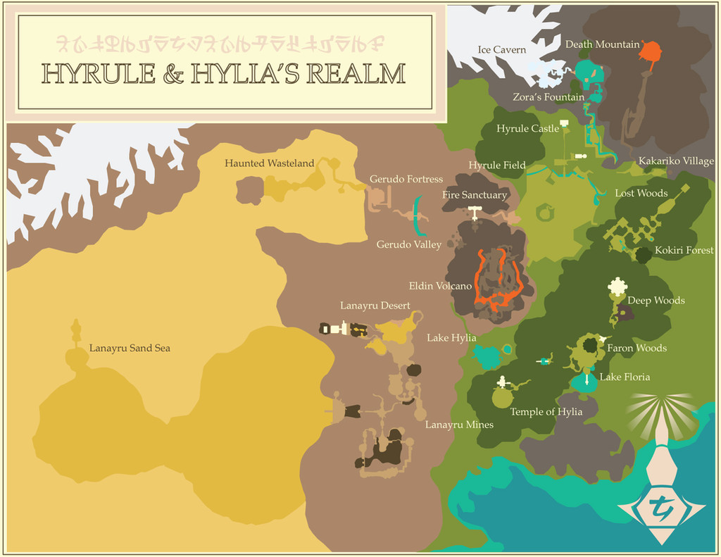
The ultimate reference for any Zelda fan,I present to you… Hyrule!
I have combined the maps of Ocarina of Time, Skyward Sword and the island locations from Wind Waker to create a composite which involves no turning or twisting; North is North here, my friends.
By lining up the Sealed Temple to the Temple of Time (Hyrule Historia – a great reference to all things Zelda being translated by hard-working fans as we speak – hints at the sage, Rauru, reconstructing the former to suit the latter as a portal to the Sacred Realm.)
Another quote from Hyrule Historia states that Hylia, the Goddess, built her Temple (later known as Sealed Temple) in "the heart of the land", which better suits the location of Hyrule Castle and Castle Town and the fact that the Temple was reconstructed to fashion the Temple of Time.
As you can see here, wet and green forests lay to the east/southeast; arid hills and desert sands lay to the west/southwest; a fiery mountain smokes to the north.
"Fiery" Eldin Province encompasses Death Mountain, Kakariko Village and Hyrule Castle (which, by the way, is where one finds Din's Fire in OoT).
"Lush" Faron Province encompasses Kokiri Forest, Lost Woods and the Zora county – one finds Farore's Wind within a fairy spring in Zora's Fountain.
"Desiccated" Lanayru Province – once a green plain and a vast inland sea – encompasses Gerudo Valley & Fortress, Haunted Wasteland and Desert Colossus; one finds Nayru's Love in a fairy spring deep within the desert.
EDIT 2.1: Color scheme changed, with the addition of a 45 degree tilted Twilight Princess world map.
EDIT 2.2: Color scheme changed again, Twilight princess overworld now North-oriented; some locations from Ocarina of Time adjusted to compensate.
Related content


Comments: 49

I think this one best represents all of Hyrule as shown.
👍: 0 ⏩: 0

You've done a respectable amount of work on this. I can't say whether I'd necessarily agree with all your conclusions, but it's a beautiful work.
👍: 0 ⏩: 1

Thank you very much. To be honest, my ideas on placement have changed quite a bit since I posted this, and will likely continue to do so as more details come forth from future Zelda titles.
👍: 0 ⏩: 1
I have some ideas of my own. Like, I think there may have been more than one Zora's Fountain, but only one Lake Hylia - and Lake Floria is not Lake Hylia. Also, I think Lake Hylia probably didn't exist as a lake during Skyward Sword, and was actually one of the dry pits in Lanayru - possibly the one next to the former Temple of Time. And my friends and I can't agree over whether Hyrule Castle moved between OoT and TP or whether the Pedestal of Time (and the Temple of Time around it) moved instead, or whether neither moved but the Lost Woods are actually a geography-shuffling supernatural force that encroached on and enveloped the Temple of Time and changed its location within Hyrule.
👍: 0 ⏩: 1
I had read a post online somewhere, and the commenter came to that same conclusion: that the pit with the dead tree by Lanayru's Temple of Time would later become Twilight Princess' (and Ocarina of Time's) Lake Hylia. I think it's definitely possible, but there are plenty of other theories too with just as much merit.
The Lost Woods! Now that is a box of goodies with a whole lot of nuts… They seem to move everywhere, either by innate magic or merely by artistic license. We may never really know…
I felt once that there must have been two Zora fountain's, but I think that there may only be one: however, the river course(s) which are fed from it clearly seem to shift through time. The course of the River Zora that ran behind and around Kakariko Village to curve it's way out before the Castle gates — what is seen to be Kakariko Gorge in Twilight Princess — seems to be either bone-dry or inaccessible, but may likely still connect somewhere north to the new river-proper. That is what I believe.
👍: 0 ⏩: 1
Nah, Kakariko Gorge has water and contains Zora's River. The river's path lines up with that gorge as well as a few others.
But generally, in Twilight Princess, I get the impression that Hyrule is a giant graben of geological (perhaps tectonic) subsidence, like a rift valley. That land has sunk even more than it had by Ocarina of Time. Fridge brilliance suggests that it was already below sea level in the other timeline when the Great Flood occurred, if it hadn't indeed always been below sea level.
👍: 0 ⏩: 1
Yes of course, but in-game it is merely implied: you cannot physically observe the water course, just the gorge. However, I still stand by my own and say that there is only one source of the Zora River, in the north; our hero just happens to explore different branches of it through time (particularly in Twilight Princess).
Hyrule in a graben, now that is a very intriguing thought… It would definitely make a lot of sense, and easily explain the volcanism of the region and the subsiding land throughout all of the timelines. Interesting… very interesting.
")
👍: 0 ⏩: 1
I also theorized Lake Hylia is a different kind of volcano - a maar - but that the water temple exists to continually purify the water so that it never becomes oversaturated with deadly gases. A friend also suggested that the OoT lake and the TP lake are actually the same lake, but that the floor of OoT's lake collapsed sometime before TP's lake, creating the much deeper depression. If the water temple itself collapsed, then it may have been relocated deeper down the pipe.
👍: 0 ⏩: 1
Very good. I've read several thoughts on the formation of Lake Hylia, and a maar lake makes the most sense. It accounts for the unusually round and deep depression of it all, and if Hyrule truly is a tectonic graben fold (which seems to be the case), a maar could develop there easily!
The Water Temple being a purifier, however, that's new to me… Interesting. The mechanism of just how it would do so is beyond me, though.
Speaking of tectonics and volcanism, the fertility of the region's fields and forests could also be attested to the mineral-rich soil typical of volcanic regions here on Earth. As well, with a violent-enough upheaval of land due to a particularly strong shift, the rivers and rains that once watered the depression of the Lanayru Sea would have ceased, leading up to it's ultimate desiccation into the dustbowl we know it as today.
👍: 0 ⏩: 1
Well, the principle dangerous gas a maar lake can emit is carbon dioxide. It gets trapped in the lower levels until it oversaturates, and then erupts up and kills life on the surrounding land. And since CO2 is also heavier than air and tends to hug the ground, the gas cannot simply be released into the air, either - not if Lake Hylia is to become a safe place to visit and linger by the time of The Minish Cap. Perhaps the Water Temple is doing what plants do, by absorbing the carbon and releasing oxygen.
👍: 0 ⏩: 1
I'm well aware, thank you. And the idea of the temple being a purifier makes sense, however, I'm still at a loss as to the mechanism on how it could do so. Perhaps the stone it's made of is a limestone — limestone can "lock-in" carbon quite well. It is also quite suitable for carving… Hmm, unless there is some unseen machine or magic at work, that could be the mechanism behind it's purpose as a purifier.
There is so much potential to be found!
👍: 0 ⏩: 1
To be honest, I mainly assumed fairies purified it. I first got this idea from the fairy spring in the middle of Lake Hylia in ALttP. But there being a water temple there makes me think the facilities are related.
👍: 0 ⏩: 1
Water purification through Faerie magic… It has potential, I give you that. Maybe it's a combination of natural processes {limestone carbon sink} and supernatural means {faerie magic}. Who can say for sure?
In other news, do you play Minecraft? I found a great Ocarina of Time map today on ZeldaUniverse , built by user Kezsonaj. It's pretty cool, and very well done.
👍: 0 ⏩: 1
Yes, I play Minecraft, and I've explored custom maps based on Wind Waker and Twilight Princess. But I was never that fond of the maps in Ocarina of Time; they felt too artificial in some places (Lost Woods, etc.) and too bland in other places (Hyrule Field, etc.).
👍: 0 ⏩: 1
I have to say, this one is really well done. They've even added some locales from Majora's Mask (Snowhead and Great Bay), which — while inaccurate in their placement within Hyrule — do offer some great places to explore!
The map also features teleportation, which it utilizes when going "seven years forward/backward in time", travelling through the Lost Wood secret paths (to Zora's River and Goron City), and "swimming" the underground channel between Lake Hylia and Zora's Domain.
👍: 0 ⏩: 1
Although I never cared much for Majora's Mask (the time limit gave me too much anxiety to enjoy the game), I do have a theory there as well. Perhaps Termina *is* an alternate universe Hyrule, branching from really far back, even before the Era of the Goddess Hylia. The Great Bay could be the Lanayru Sand Sea that never lost its water and never became a desert. That said, I never played Majora's Mask enough to confidently try to match more of its geography to Hyrule's.
👍: 0 ⏩: 1
It really does match up well in that respect. In essence:
North: Mountain region (Hyrule = arid, active volcanic; Termina = frigid, extinct volcanic)
South: Wetland region (Hyrule = depressed maar lake, springs; Termina = raised maar lake, springs, extended wetlands)
East: River Source + Highlands region (Hyrule = river course, thick woodland; Termina = river course, arid hills)
West: Seabed region (Hyrule = arid, dried sea bed; Termina = proper sea)
👍: 0 ⏩: 0

I appreciate your opinion and I'm happy you shared it with me, but I must disagree on some points.
IMHO the western desert (Haunted Wasteland, Desert of Doubt/Mystery, Gerudo Desert, Sand Sea) are one in the same due to their vast size; remember, the Sand Sea was once a landlocked sea of water before it dried up and filled in with the windblown sand from the mainland surrounding it. Of course if a landscape can change that drastically, there is nothing stopping the heart of the Sand Sea from expanding "inland", say, into the Lanayru Desert basin. I just think the elusions to the Sand Sea to the Haunted Wasteland are too uncanny not to be a blatant "this-is-the-same-place-in-a-different-time".
I do agree however that the Spirit Temple/Arbiter's Grounds are one in the same location, having been retrofitted from a sacred temple into a prison (of a sort). There's a lot of evidence to support this claim, namely it's location in the desert and the use of Gerudo artefacts (Goddess statues, Gerudo script, similar dungeon gimmicks & mechanics).
The second point you made regarding Lake Floria and Lake Hylia is something I must contend with, too: both lakes are southward, and clearly allude to each other. And while in-game text mentions Lake Floria as "the source" of water in the land, just as Zora's Domain is known to be, notice how water flows into the lake basin from several directions, but only flows out from the lake , and underground no less, at one location — and even this is a dead end, leading in to Faron's lair. Those rivers & waterfalls leading into the lake are the true source, somewhere off-screen, while the lake is… well, the collection point. This is just like Lake Hylia's layout in Ocarina of Time. Even the underground entrance into the Parella's realm is similar to the underground passage linking Lake Hylia to Zora's Domain. Most importantly, Zora's Domain is always, always uphill and flows from a northerly position (northeast in most games to be precise), so suddenly appearing far to the south would make little sense in keeping a stable continuum, artistic license or not.
I do agree that the relationship between the Zora and Parella is too uncanny to be a coincedence; surely they are meant to be the same people, just one is more "primitive" than the other. They could have easily moved "up river" in later ages, this wouldn't be unreasonable or unheard of: even the Goron's don't have a permanent home in the Era of Sky as far as we know, they travel the land as a curious tribe of archeologists and businessmen.
Essentially, artistic license aside, the most-basic layout of Hyrule remains the same throughout time (and game title): there are mountains and river valleys to the north complete with tall peaks and waterfalls, a grassy central basin where the masses live, a southern lake bordered by a primeval woodland growing over remnants of the past, and far to the west… an arid desert and/or ruins of an ancient civilization.
Following this pattern, even the oddball that is the Minish Cap fits really well into the continuum (Mount Crenel ("the volcano"), Royal Valley and Veil Falls ("the source") lie north; Minish Woods and *Lake Hylia are eastbound; westward lie ruins of an ancient civilization (who built/used automatons), and in the centre of it all is the kingdom of Hyrule Proper with it's castle and towns and farmlands.
*This incarnation of Lake Hylia is bordered by woodland much like most incarnations are, but it's general location is offset quite a bit from it's usual position as a southern body. This may be a case of "mistaken identity", i.e. the people named this small body of water after the Goddess in this Era, but later renamed Lake Floria (off-screen) to honour Her Majesty, and the sylvan lake was forgotten (?). Or it's a simple matter of artistic license, attempting to cram a variable world into a square frame.
👍: 0 ⏩: 0
If you believe the correlations and evidence provided in-game and by fan speculation, they have done some of that with the Oracle series: Labrynna is the central region in and around Saria town (Yoll Graveyard is the King's cemetary, Rolling Ridge is the dividing range, Zora Seas are the wide bay, Crescent Isle is the Island Palace, etc.) and Holodrum is the southern half of the East Continent.
Of course, if they elaborated the whole realm more so, and in HD, with lush forests, verdant fields, tall mountains, shifting sands, vast seas, deep caverns and terrifying monsters… *drools*
👍: 0 ⏩: 0

I've just found this map, and I absolutely love it. Very, very good work on it! I think it fits the most considered maps of Hyrule all very well and it matches them up considerably!
👍: 0 ⏩: 1
Thank you very much! I'm always working to improve on these: I've made a few since this one, but not all of them are uploaded yet.
👍: 0 ⏩: 1
Really? o: I'd love to see more. You make incredible maps.
👍: 0 ⏩: 1
Thank you.  (Smile)")
👍: 0 ⏩: 1

No problem, anytime; thank you for the watch and all of the faves.
👍: 0 ⏩: 1
Not at all! I absolutely love your maps and I didn't notice a lot of them before!! They're spectacular references.
I'm actually rather tempted to ask if you minded if I used them for references for members to use for a Zelda-based RPG I manage.
👍: 0 ⏩: 1
I would be alright with that, just as long as I'm credited.
Of course, if you need a good fantasy illustrated map for the RPG, let me know.
👍: 0 ⏩: 1
Absolutely! Thank you and I'll certainly do that.
👍: 0 ⏩: 0

It makes sense, but I'm trying to figure out how Link would have gotten to Kakariko in OoT based on this map.
👍: 0 ⏩: 1
Thanks. I'm not sure, maybe the path was longer than we thought?
This map here details OoT much better, if you're interested: [link]
👍: 0 ⏩: 0

You may have to download the image: it's really quite large, 3696x2213px. Thanks for the heads-up!
👍: 0 ⏩: 0

This map is off
Faron Woods from TP is actually OoT's Hyrule
Hence why the Temple of Time is in the woods
It's good, but if you could update it, it would be perfect
👍: 0 ⏩: 2
I've made an update, thanks again for your input
👍: 0 ⏩: 0
I actually don't have TP Hyrule in this map as of yet, but I appreciate your input
👍: 0 ⏩: 1
Wait no, Eldin Volcano is off
The Eldin Volcano in SS is OoT's Death Mountain, TP's is different
The land around the volcano settles down before TP, hence why so many mountains surround lower Hyrule Field
Do you have any separate maps from the games? I'd like to make my own map of where everything matches up
👍: 0 ⏩: 0

One last thing: if you like challenges, try to add Hyrule map from Twilight Princess. It would be amazing!
👍: 0 ⏩: 2
I've made some changes: added twilight princess overworld to the mix. Come take a look.
👍: 0 ⏩: 0
I have tried on my own: it's awkward. Needs some work.
👍: 0 ⏩: 0
Usually, I don't like when people mix different Hyrule game map. For me, each Hyrule map is made for one game and they cannot be mixed without nonsense. But I must say that this ''overall map'' of Hyrule is well done!
👍: 0 ⏩: 1
Thank you. There are similarities between all of the games of course, but Skyward Sword and Ocarina of Time are very similar; Wind Waker has the potential too but you see little of the geography. Even still they world maps aren't all the same & I honestly believe that's due to artistic license more than anything else.
It's a legend after all.
")
👍: 0 ⏩: 0

Thank you, you're too kind

👍: 0 ⏩: 1

Thanks – for the comment and the fave!
👍: 0 ⏩: 0

| Next =>