HOME | DD
 OkamiTakahashi — -WIP- Custom Sodor Map Redone
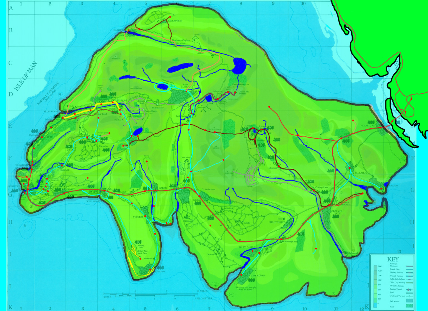
Published: 2012-09-25 21:37:35 +0000 UTC; Views: 14309; Favourites: 55; Downloads: 922
Redirect to original
Description
=*PLEASE NOTE*=This is still very much a Work in Progress; it's not finished yet.
Latest Update: September 20th, 2014.
Overall Changelog:
*Added markings for Harwick, Farmer McColl's, S&R Centre, Boxford, Wharf, Central Bridge, canon Bluff's Cove location, Maithewaithe, custom mainland goods station "Barrow Goods"
*Fixed the line to Great Waterton so it doesn't go beyond the Culdee Fell Railway
*Added the Lakeside-Ulfstead extension for the Skarloey Railway
*Added the Harwick line
*Stopped the Harwick line at Peel Godred to prevent overlapping with Arlesdale and Mid-Sodor Railways
*Added loop line at Aluminum Works/Peel line to go around Black Loch
*Highlighted what appear to be either rocky/craggy areas and/or old and disused lines
*Added loop for Search and Rescue Center and Boxford, connecting to Maron, Cronk and Suddery
*Altered Courtney's Brendam loop to not go through Brendam and Wellsworth towns
*Started Brendam loop at the Sodor China Clay Quarry as part of the alteration
*Added points at Wellsworth and after Cronk for Brendam loop as part of the alteration
*Adjusted location of Vicarstown Dieselworks to a distance before Vicarstown proper
*Added Shane Dooiney/BMQ to Abbey branch
*Changed previous Bluff's Cove location to Callan
*Changed Maithewaite to new location as unnamed station on Ffarquhar was Dryaw Goods Station in actuality (new location subject to change)
*Moved Greater Tidmouth to proper spot on mainline.
*Added Maron-to-Arlesburgh Branch
*Stopped Maron-to-Arlesburgh Branch at Arlesdale and Arlesdale End to prevent overlapping with Arlesdale Railway
*Made rivers and lakes visible
*Increased size of Black Loch based on slight 2010 inaccuracies and added more rivers near it
*Increased length of River Hoo to cross paths with Great Waterton line and add marking for Rolling River Bridge
*Added/moved markings for Sodor CC Quarry, Elephant Park, Rumblin Falls, Harwick, Rolf's and Lord Callan's Castles, Windmill, Sodor Airport
*Re-added line to Sodor Airport
*Added line from Ffarquhar to Arlesdale End branches for service to McColl farm
*Increased dimensions a bit
*Added Isle of Walney and Vickerstown
*Move England up a bit
*Added real life accurate marker for Barrow-in-Furness
*Redesigned Barrow to fit with NWR, removing more developed bits
*Added small loop for Barrow-in-Furness goods station and adjusted marker position
*Fixed Markers for Harwick and Rolling River Bridge
*Fixed branch for Shen Valley
*Recoloured tunnel areas
*Removed extra rivers at Black Loch
*Fixed outline of Island and colouring
*Fixed outline around Rescue Center area
*Added marker for bridge to Misty Isle
*Moved Maithewaite to SI3D IoS Location
*Added marker for SI3D filler station "Woodland Junction"
*Squeezed in orange marker for SI3D filler "A R Hal" abandoned station between where their TV series Elsbridge (My Lower Knapford) and TV Series Knapford (My Upper Knapford) is.
*Added branch and marker for SI3D Knapford Harbor (Upper Knapford Harbour. RWS Knapford (SI3D's TV Series Elsbridge Harbour) is now Lower Knapford Harbour
*Fixed DeviantArt problem with not showing true full size of map.
*Added marker for Henry's Forest- now confirmed to be in-between Cronk and Killdane.
*Recolored Arlesdale Railway line as the previous color was blending in with the greens on the map.
*Added a marker for Ulfstead Castle.
*Edited the Maron-Arlesdale End Branch to have a junction at the bottom of Gordon's Hill in accordance with the KOTR layout.
*Edited the Ulfstead Extension of the Skarloey Railway to go partway through the town of Ulfstead and head towards the castle where it joins with the NWR as the dual-gauged Ulfstead Castle Estate Railway.
*Redrew the line from Maron to Center Island Quarry as the old line I had draw was actually for a roadway I was previously unaware of.
*Added the Peel Branch split to this part of the description as I had done it and not realized I hadn't moved it up to this part.
*Added mark for Mountain Village Station- just outside Shane Dooiney/Blue Mountain Quarry
*Moved Lower Tidmouth up further and added new marker for it.
*Moved Upper Knapford further up and recycled old Lower Tidmouth Marker for it
*Recycled old Upper Knapford marker for East Knapford
*Added line to Upper Knapford Container Yard
*Added marker for Container Yard
*Fixed layering glitch
*Split Cronk into Upper and Lower Quadrants. Lower is on the mainline and looks similar to Lower Tidmouth. Upper Cronk is a single track station on the Peel branch.
*Adjusted Peel branch segmenting off to Upper Cronk accordingly.
*Adjusted Harwick connection to Peel.
*Adjusted line for Tidmouth Harbour
*Added more new changes to to-do-list based on the Japanese KOTR/TOTB update to the famous 1992 Awdry map.
*Actually added the NG Harwick Line now.
*Added extensions to Harwick from Ballaswein to Drogan-Y-Claghan and from Harwick Junction to Seaside Line (under construction)
Changes to make for future updates:
*Add names for all markers
*Add outline and colors for Isle of Man
*Refer to complete collection to see if there are any coastal lines on the Island of Man and what gauge they are for possible bridge connection.
*Attempt to go "all out and add different shades for elevation, forest areas, built-up areas, towns, roadways, etc. (Will likely never actually happen).
*Adjust area for Upper Knapford Container Yard
*Rename Classic Bluff's Cove to Crock's Cove and move Bluff's Cove Station back to the Little Western
*Add small eastward branch to Little Western for Callan and Callan Castle and Bertram's Mine.
*Adjust the line for Peel
*Adjust the line for the SSRC, move Boxford up to Ulfstead Branch
*Keep Old Boxford Marker, relabel it as the old Summer Home (assumed to have been sold)
*Redo Shen Valley to not be at Shen Ven as previously assumed.
*Redo mainline branch to BMQ
*Move Arlesdale End to near Haltraugh
*Add Pre/Post-Brenner Retconned Locations.
*Adjust roadside line from Clay Pits to the west slightly.
*Edit Skarloey Railway layout somewhat, based on 's map in the Sodor Workshops Skype Group.
*Locate Balldarine, Cabalnoo, Callendale, Kellaby and Killiban Stations and place them on the map. This is gonna be very difficult as they have very few appearances in the Classic and Retconned Series and don't seem to appear on any Sodor maps. Balldarine is in the final Classic episode, but there are 3 filler stations, two without names, but one is the Sports Halt Station. The third has a name that can't be read. I will add the unnamed ones as well. Callendale is only in Thomas and Stepney. Calbanoo is in Gordon's Shortcut and Toby's Special Suprise. Kellaby and Killaban were only in TATMRR. I am having much difficulty actually locating Cabalnoo- I don't see any unusual stations in said episodes except for a small halt. Killaban and Kellaby are both locations on the map but I don't remember any stations for them. This SiF pool is confusing me.
That should about cover it.
Here's a creepy tidbit- By sheer coincidence, the marking I placed for Great Waterton on my original map was in the EXACT same spot as on the BMM/2010 maps. As I was using the Japanese 2010 map I had absolutely NO idea it was there as it was unmarked and only labelled in the English version.
Related content


Comments: 32

👍: 0 ⏩: 1

👍: 0 ⏩: 0

I can barely read the names of the places.
👍: 0 ⏩: 1
Again, it's something I'm working on. I don't have the names even placed on here.
👍: 0 ⏩: 1

Why have you included the SI3D Stuff in when it's not official?
👍: 0 ⏩: 1
Because I felt like it. I like the little bits of filler SI3D added in. Said locations would make for some good stories.
👍: 0 ⏩: 1
Ahh right, they aren't official though which just baffles me a little. Just saying mate :^)
👍: 0 ⏩: 0

I still have a bit of work to do before I can add the names on the map. I added a couple things to the changelog recently.
One thing I like to do is add locations from various canons, whether they're RWS, Classic, Retconned or otherwise. Once Sodor: The Modern Years premiers I will be adding East Knapford to the map, and the quarry from Tale of the Brave once the movie's released.
👍: 0 ⏩: 1
Yeah, I know, it's gonna be a long while. I'll try to get the names on there in late January/early February once East Knapford makes its debut in Sodor The Modern Years.
👍: 0 ⏩: 1
Eh, it's not that awesome, it's still very much a WIP
👍: 0 ⏩: 1


In the tv series, Elsbridge is the junction of Thomas Branchline . Do you think that there should be a lower Elsbridge and Upper Elsbridge? Just saying...
👍: 0 ⏩: 1
The TV series Elsbridge is based on RWS Knapford- on my map, what you suggested for Elsbridge is Upper and Lower Knapford on my map- upper being the Classic/Retconned station and Lower being the RWS Station. So what was called Elsbridge Harbor in the Classic Series is actually Knapford Harbour in the RWS. This map is a blend of RWS, Classic and Retconned canons in addition to bits and bobs from SI3D's IoS project, i.e. the abandoned goods station "A R HAL" (or L A N A if you go by the current version of the map). I personally prefer the former.
👍: 0 ⏩: 0
I'm keeping the labels off until the final version. This is still a WIP and things are subject to change.
👍: 0 ⏩: 0


To be precise, if this map were further retconned, where do you think the buffers leading to Magic Railroad are located?
👍: 0 ⏩: 1

I've got a quick question regarding the Peel Godred line--according to Reverend Awdry's "canon" for the books, the Peel Godred line is electrified. That being said, Is it an electric line in the current TV series?
👍: 0 ⏩: 1
TV series isn't electrified and is simply called the Peel line.
👍: 0 ⏩: 0

Looks great Jim. But when you save the pic and want to look at it closer, it get blurry.
👍: 0 ⏩: 1
Yeah, not sure what I can do about that problem.
👍: 0 ⏩: 2

Or simply make it a higher resolution. Tends to work.
👍: 0 ⏩: 0
The map's fixed. It was DA's fault, kept changing the full size to 900 pixels instead of using the original size.
👍: 0 ⏩: 1
