HOME | DD
 procrastinating2much — Physical Map of Europe

#europe #maps #mapsandflags
Published: 2020-08-24 00:52:39 +0000 UTC; Views: 7663; Favourites: 78; Downloads: 129
Redirect to original
Description
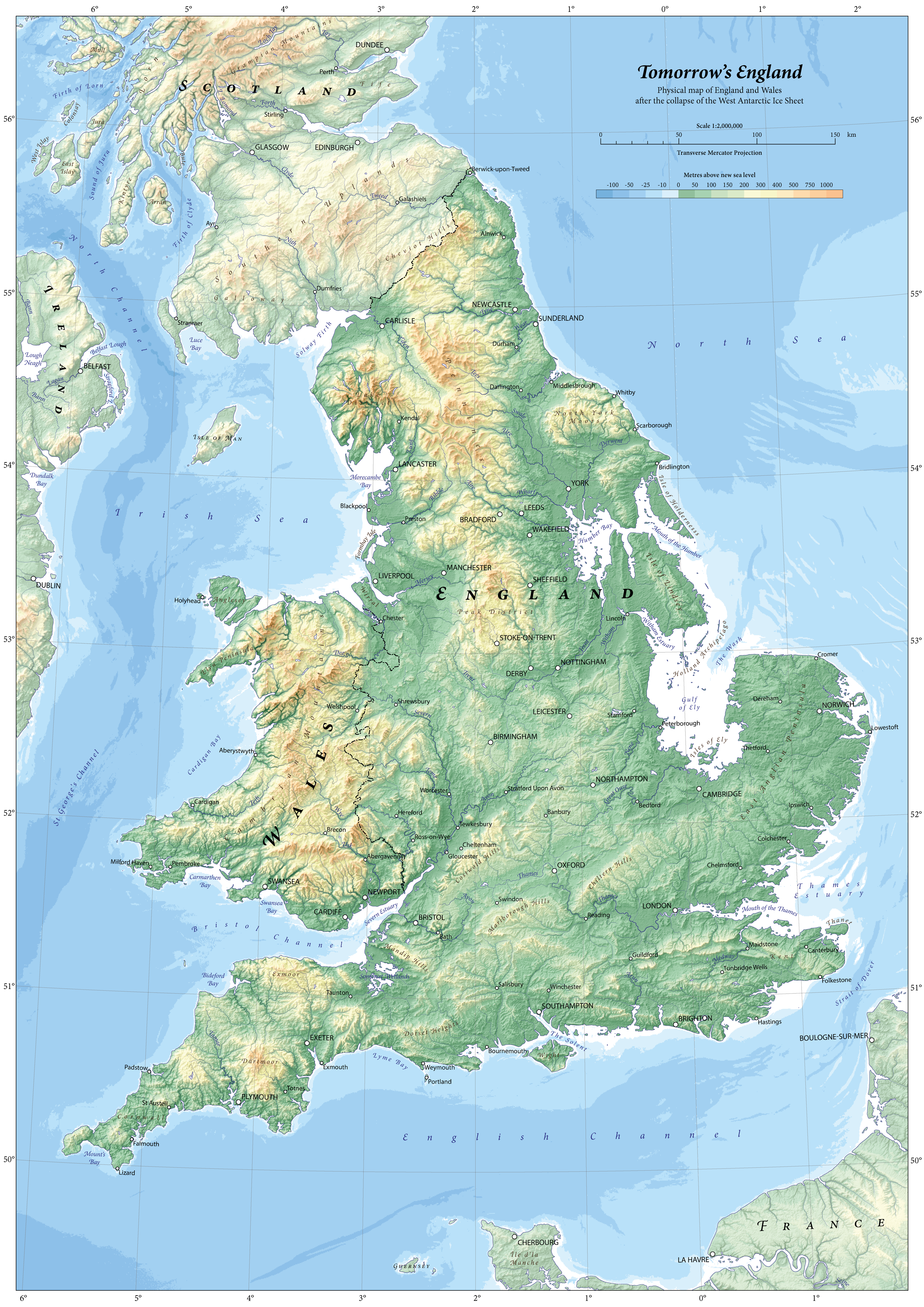
Made a map using brilliant hand-painted shaded relief from the 80s. Feedback is appreciated (Smile)")
Hand-painted shaded relief…
Townsend, Kenneth, c. 1985. Europe. Available from www.shadedreliefarchive.com/Eu…. [Accessed June 2020].
Artist is Kenneth Townsend, PA, USA. This shaded relief is in the public domain on Tom Patterson’s website since 2011.
Properties of shaded relief…
Original art scale: 1:12,466,660
Original art size: Not known, Scanned from a 10 x 8" film transparency.
Cropped digital art size: 39.84 × 36.68 cm at 300 DPI, 4,705 × 4,332 pixels
Additional information regarding the shaded relief…
‘R. R. Donnelley and Sons Cartographic Services commissioned the creation of this shaded relief under the supervision of Herwig G. Schutzler. The Cartographic Services unit at R.R. Donnelley is now defunct. Upon going out of business, Donnelley transferred ownership of the relief art to GeoSystems Global Corporation, which later became MapQuest, owned by AOL. When MapQuest sold off their custom cartography unit, GeoNova, a successor company, became the new owners of the relief. GeoNova has since failed. Herwig G. Schutzler then donated the film transparency of this relief to the U.S. Library of Congress, where it is permanently stored along with other Donnelley relief art. The location of the original relief art is not known.’ From www.shadedreliefarchive.com/Eu….
Coastlines, boundary lines, lakes, and rivers from…
Made with Natural Earth. Free vector and raster map data, available from www.naturalearthdata.com/downl… [Accessed June 2020]
Placenames from…
The Times, 2017. Reference Atlas of the World. 8th ed. Glasgow: Times Books.
…though in some places (such as the name of the Atlantic Archipelago) I have opted for more politically neutral names.
Bathymetric data from…
The GEBCO Grid, GEBCO Compilation Group (2019) GEBCO 2019 Grid (doi:10.5285/836f016a-33be-6ddc-e053-6c86abc0788e), available from www.gebco.net/. [Accessed March 2020]
Colour ramp for bathymetry designed by me to be light so to not drown out the colours of the hand-painted shaded relief.
Typography…
· Sans-serif font (Lato) for cultural labels, including…
o Countries (bold)
o Dependencies (regular)
o Cities (regular)
· Serif font (Georgia Pro) for physical labels, including…
o Areas (all caps, italics)
o Features (italics)
o Summits (italics)
o Water (Italics, blue font colour)
Cities are considered ‘major’ if they have a population greater than 1.5 million.
Finished map is exported first from Illustrator with a DPI of 900. This high-resolution image is resampled in Photoshop to create the final image at 300 DPI. This process generates a final map with superior anti-aliasing.
Related content


Comments: 4

👍: 0 ⏩: 1

👍: 0 ⏩: 0

👍: 0 ⏩: 0

👍: 0 ⏩: 0