HOME | DD
 procrastinating2much — Map of Medieval Scotland

#historical #maps #medieval #scotland #shire #mapsandflags
Published: 2020-05-14 19:33:37 +0000 UTC; Views: 13706; Favourites: 122; Downloads: 89
Redirect to original
Description
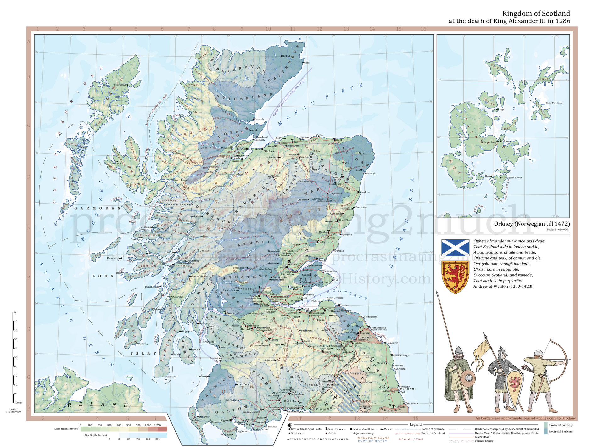
Shire boundaries from…
Wikishire, 2020. Index of /lookup/individual/shp. [Online] Available from wikishire.co.uk/lookup/individ…. [Accessed May 2020]
…which is subject to the Creative Commons Attribution-ShareAlike 3.0 Unported Licence.
List of shires extant by 1305 from…
Wallace, James (1890). The Sheriffdom of Clackmannan. A sketch of its history with a list of its sheriffs and excerpts from the records of court compiled from public documents and other authorities with preparatory notes on the office of Sheriff in Scotland, his power and duties. Edinburgh: James Thin. pp. 7-19.
… which describes Edward I’s Ordinance for the Government of Scotland, a document which lists the 23 shires of Scotland, not including Roxburgh, which was not recorded as it was under jurisdiction of the sheriff of Selkirk at the time.
Burghs from…
McNeill, P. G. & MacQueen, H. L., 1998. An Atlas of Scottish History to 1707. Revised ed. Edinburgh: The Scottish Medievalists. pp. 218-20
Bathymetric data from…
The GEBCO Grid, GEBCO Compilation Group (2019) GEBCO 2019 Grid (doi:10.5285/836f016a-33be-6ddc-e053-6c86abc0788e), available from www.gebco.net/. [Accessed March 2020]
Coastlines from…
GADM v3.6 © 2018 GADM, available from gadm.org/data.html [Accessed February 2020]
Crossed swords battle symbol from…
Wikimedia Commons, the free media repository, 2008, available from commons.wikimedia.org/wiki/Fil… [Accessed May 2020]
7-class colour scheme from…
Brewer, Cynthia A., 2013. ColorBrewer: Color Advice for Maps. www.ColorBrewer2.org. [Accessed May 2020].
…which uses a colour scheme I have selected for its ability to distinguish between each colour as well as the ability to read text and symbology placed atop it.
Shire boundaries that differ in 1305 from their regular boundaries…
· Stirling and Dunbarton
o Stirlingshire includes Dunbartonshire’s Cumbernauld exclave as this was not transferred to Dunbartonshire until the reign of David II (1324-1371).
· Inverness, Argyll, Ross, Caithness, Bute
o The sheriff of Inverness was responsible for what would become Argyll, Ross, Caithness, and Bute.
§ Argyll would be appointed a sheriff c. 1326. Bute would be appointed a sheriff c. 1388.
§ Ross and Caithness were formed as separate shires by a 1503 Act of Parliament.
§ Sutherland was separated from Inverness in 1633 by Parliament.
· Kirkcudbright and Dumfries
o The sheriff of Dumfries was responsible for what would become Kirkcudbrightshire.
§ Kirkcudbrightshire was created in 1369.
· Cromarty
o Cromartyshire included only the area immediately surrounding the town, with no exclaves for itself, until 1682.
· Elgin and Forres and Nairn
o Elgin and Forres, the county encompassing Elginshire or Moray, also encompassed what would become Nairn.
§ Nairn is established at the close of the 14th century.
This map shows major events and battles of the Wars of Scottish Independence. Events shown…
· Capture of Berwick in 1296
o First event in the First War of Scottish Independence. Marked the English invasion of Scotland.
· Battle of Louden Hill in 1307
o First major victory by Robert Bruce against England.
· Battle of Bannockburn in 1314
o Landmark Scottish victory, forcing English retreat.
· Declaration of Arbroath 1320
o Letter addressed to Pope John XXII asserting the independence of Sctoland.
· Battle of Neville’s Cross
o Major battle of the Second War of Scottish Independence in which King David II was captured, leading to the ransoming of the Scottish King that resulted in a truce.
Process…
This was the first map I created Adobe Illustrator, so much of this process was very trial and error’
· To create coastlines, I exported GADM shapefiles from QGIS as a raster, loaded it into Illustrator, and used the programme’s ‘Image Trace’ function with a little fine tuning to get the desired outcome. I fine-tuned it manually with the ‘Pencil’ pool, removing small islands that were unnecessary clutter.
· To create other geographical features, I exported their respective shapefiles from QGIS as a raster, loaded them into Illustrator, and manually traced them with the ‘pencil’ tool.
· I created separate vector shapes of every shire through Illustrator’s ‘Live Paint’ function.
· I placed most labels to subtly flow parallel to the projection’s latitude lines. This was done by creating a grid atop the map in QGIS with lines every 0.05 degrees and exporting only the grid (with no other layers visible) and importing the image into Illustrator as a sort of guide to place labels atop.
· To create type knockouts, I followed a guide by Daniel Huffman available from somethingaboutmaps.wordpress.c…. [Accessed May 2020]. Basically…
o I created a master layer containing the labels layer and all vector layers I wanted to be knocked out by text, checking the “Knockout Group” box in the ‘Transparency Panel’.
o I selected all text in the labels layer and, in the ‘Appearance Panel’, added a stroke with a thickness of 1pt to sit underneath the “Character” layer of the ‘Appearance Panel’. I then reduced the opacity of this stroke to 0%, knocking out all vectors that sit underneath the labels layer.
Style…
· I believe much of my hithero maps suffer from a severe lack of clarity and focus. This map aimed to display clearly the state of the Kingdom of Scotland in the Medieval era. Readability was therefore my primary concern.
· I considered firstly what this map aimed to show. In order of importance, this map was to show…
1. Scottish shires extant by 1305, the date of the Ordinance for the Government of Scotland, which lists them. This is because the slow creation of shires in Scotland represents a crucial development in medieval Scotland’s history: the centralisation of Scotland and the expansion of royal authority.
§ The importance of this is indicated by it being assigned the most dominant visual element: colour.
2. Scottish burghs throughout the medieval era. This is because trade made up a vital part of Scotland’s economy. The growing number of burghs throughout the medieval era coincides with the growth of this trade and the beginnings of the urbanisation of Scotland.
§ The importance of this is indicated by it being assigned a dominant visual element: a high density of labels and symbology.
3. Events of the Scottish Wars of Independence.
§ I selected a small number of key events within the Wars by adding sub-labels to existing burgh’s labels to expand on the burgh’s role in the Wars or adding entirely new labels such as battle labels. The importance of this is indicated by it being assigned a minor visual element: a small density of sub-labels, labels, and symbology.
4. Major geographic elements, such as major rivers. These rivers would play a key role in the Wars of Independence and are crucial for understanding the military history of Scotland as well as how burghs were linked by water.
§ The importance of this is indicated by it being assigned a minor visual element: a low density of labels with no symbology.
· For the most part, I have used a serif font (Book Antiqua) for natural labels and a sans-serif font (Gill Sans MT) for cultural labels.
· Much of the style of this map was influenced by a historical atlas I picked up from the University Library before the Lockdown. With the library shut during the Coronavirus Emergency, I was stuck with the book, and spent a lot of time looking through it, aiming to mimic its clear, informative, and classic style. (Darby, H. C. & Fullard, H., 1970. The New Cambridge Modern History: Volume XIV Atlas. Cambridge University Press ed. Cambridge: Cambridge. p. 95)
Related content


Comments: 4

👍: 1 ⏩: 0

👍: 1 ⏩: 1

👍: 1 ⏩: 0
