HOME | DD
 thevizir — Map: Isle of Nohn 2011
Published: 2011-07-11 04:21:46 +0000 UTC; Views: 3789; Favourites: 21; Downloads: 40
Redirect to original
Description
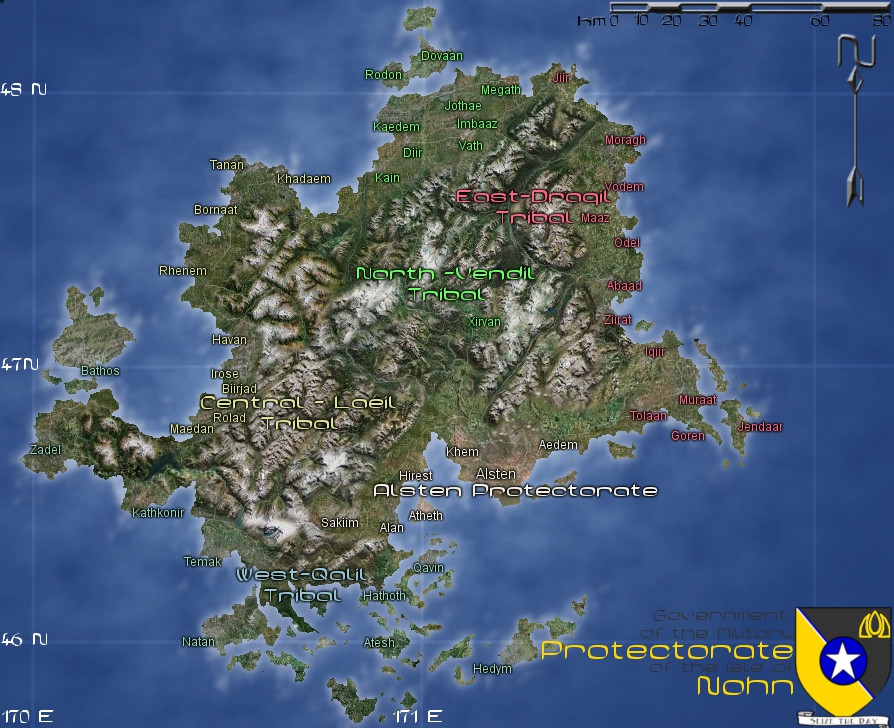
An updated map of the Isle of Nohn for another online RPG I'm involved in: NationStates. Maybe you've heard of it. Anyhow, pretty perfect for a policy wonk/social sciences nerd/journalist such as myself. Not that I'm the most active bloke there, but I'm not very active anywhere (Wink)") .
. Anyhow, same as before. Nohn is the capital isle of Cirundi, seat of the unified government of the civilized syth since the middle of the Reconstruction Era. The central city of Alsten became of the largest on Cirundi, and the isle's population exceeded 40 million before Cirundi's destruction. When the Fall occurred and portions of Cirundi were flung all across the multiverse, Nohn itself was shattered into 10 different copies, some ending up on fantasy worlds, others thrown back in time... this copy here ended up on a parallel Earth in the 1960s, where due to bad policy decisions, it allied with the Soviet Bloc, declared war on the west, was invaded by NATO, and has since been a NATO protectorate for the past 40 years. Fun times.
And that's where the nation stands as I'm playing it on NationStates. We'll see where I take it from here!
This map was used by taking satellite images from Google Maps, and using GIMP's clone tool to slap them down over the map of Cirundi I drew. Been touching it up with various other map-making techniques, trying to perfect a modern/near-future style map for the Isle, as well as get its size and location down solid.
The syth, this map, and the isle of Nohn belong to yours truly, . If you've got any questions, comments or concerns, feel free to ask, and I'll respond as quickly and efficiently as I can
")
Related content


Comments: 3

Great work.. I dream about maling a map with this kind of look. I did't feel lucky mayself using th eclone tool with take outs of google maps or nasas blue planet resources. It may be your nice result is from using all the other little map and gimp tricks in the right way
Also you may havve a tip in what resolution or zoom level you found the best sourcematerials?
👍: 0 ⏩: 1

I honestly cannot remember here... sorry. I suppose 'whatever the scale you're doing your map in so the features are the right size,' would be the best answer, but you probably already knew that...
And yeah, it did take a while to get it looking decent. I used a large brush with fuzzy edges for the clone tool, and used a total of three source locations - the Alberta Rockies, the northern BC coast, and farmland in southern Ontario - to make the terrain. The water was made separately using solid noise and gradient maps, as I didn't feel like copying that over had as nice a result.
👍: 0 ⏩: 1
Thank you. This gave me a little guidance for try out some things.
👍: 0 ⏩: 0