HOME | DD
 Vegetabelle — Palestine in the Time of Christ
Published: 2012-09-16 00:20:22 +0000 UTC; Views: 520; Favourites: 2; Downloads: 0
Redirect to original
Description
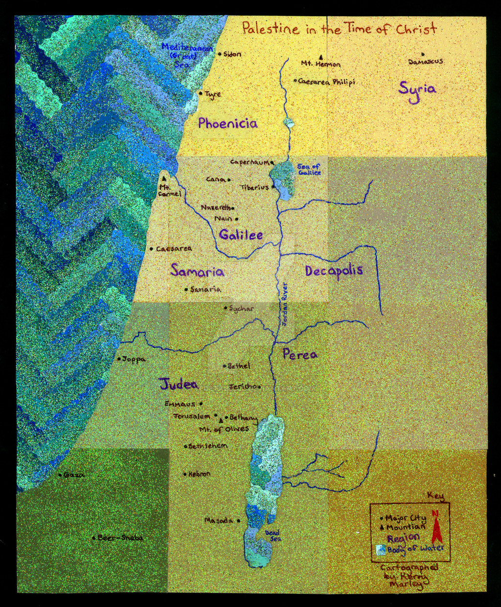
This was a project I made as an assignment for a religions class at school, which I made a 102% on.I used paint color cards from a hardware store. (The land cards were textured to begin with, but the water cards were plain.)
For the land, I glued down the cards relatively close in color to an actual map of the Israel/Palestine area onto a sheet of notebook paper. Then, I mixed gold, bronze, yellow, white, and orange glitter into matte Mod Podge, and painted over the sheet of paint cards.
For the water, I cut the cards with zig-zag scissors. (The only ones I could find at my house were broken. The metal cutting part had come detached from the plastic side on one of the arms, so cutting these became rather difficult.) Next, I glued the strips into a zig-zag pattern where colors ranged from the lightest on the right to the darkest on the left. Again, I glued to a sheet of notebook paper. Then, I mixed green, teal, dark blue, white, and dark purple glitter into glossy Mod Podge, and painted it over the zig-zaps.
Next, I took a print-out map of Israel, and cut the coastline of the land as acurately as possible. Then I cut down the ocean page to minimize wasted texture. From the left over zig-zags, I cut out the other major bodies of water. (i.e. the dead sea, the sea of Galilee, and the other lake thing that I don't actually have labeled.) I also used a timy square of the zig-zags for the map key.
The map details were hand written/drawn in fine point sharpie pens. I used a template for the rivers for closer accuracy. However, I found out later that the template I used was not completely accurate. The river fork directly above Decapolis apparently stops sooner, and does not cut down the full length that I have it. Also, the last of the 3 tributaries to the dead sea, the one closest to the bottom of the map, apparently is flipped backwards.
In case you cannot read the map key, Rivers are drawn and labeled in royal blue, other bodies of water are labeled in royal blue, Cities and Mountains are labeled in black, Regions are labeled in purple, the Compass is drawn in red, and additional information and labels are in brown.
The final project was mounted on black matte board.
Please note that again, this map is decorative, and if you tried to use this as a map in the actual state of Israel, you'd be hopelessly lost. Especially since this is representative of the area in approximately 50 A.D.
Related content


Comments: 6

This is wonderful. I love how the textures play back and forth off each other. Make more.
👍: 0 ⏩: 1

Thank you so much! ^_^ I will probably do so.
👍: 0 ⏩: 0

I just got it in my notifications! Yours is soooooooo pretty. I really loved the colors of the paper you used. ^_^ It was nice to see something not boring and scribbled on notebook paper the hour before like most people's.

👍: 0 ⏩: 0
")