HOME | DD
 vorropohaiah — INNER SEA poster map WIP

#fantasycartography #fantasymap #worldbuilding #elyden #vorropohaiah
Published: 2017-08-06 09:48:42 +0000 UTC; Views: 10672; Favourites: 107; Downloads: 30
Redirect to original
Description
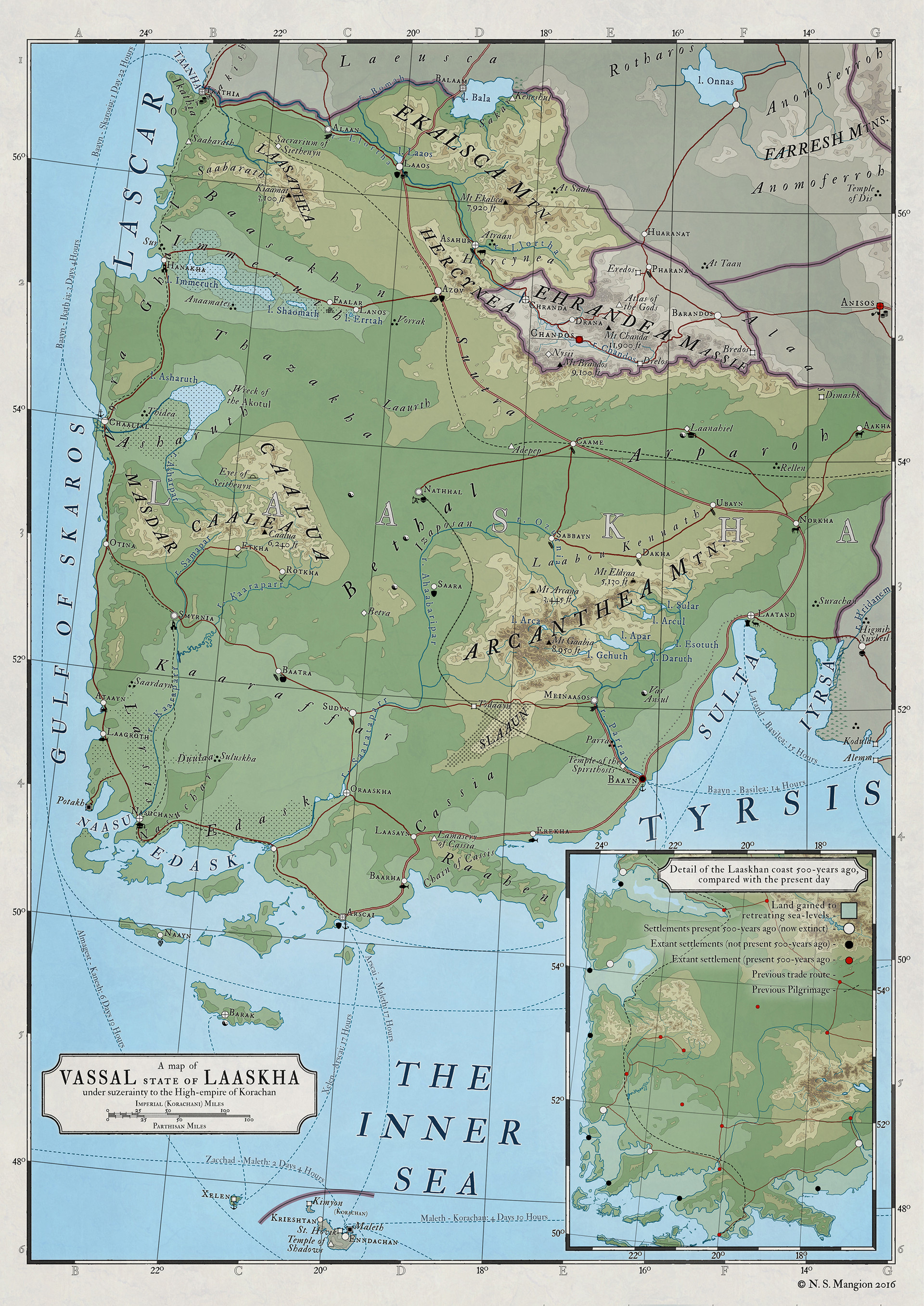
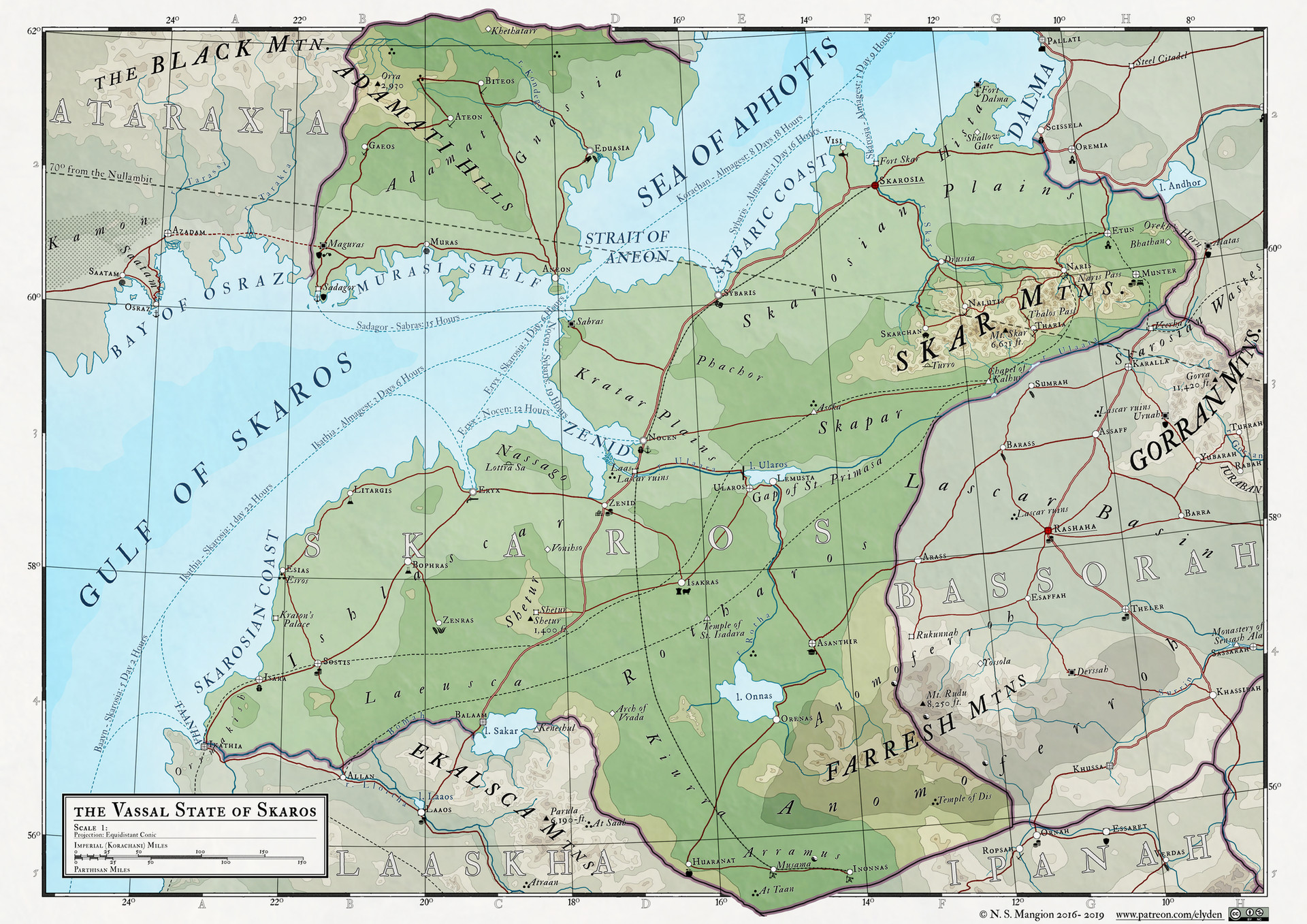
So, after close to two years and 23 maps, I'm ready to start work on the poster (A0-size) map I've been targeting. I've been slowly stitching the individual maps together into a 'collage' that I've been updating since July last year, though that's deceiving, as it;s not exactly the way I'm going about this.The individual maps start life as one of two continental maps (Llachatul to the north of the Inner Sea and Sammaea to the south of the Inner Sea). The reason they're divided in two maps is simple - together they would be so large as to make rendering too time-consuming (I could argue it's too time-consuming as it is anyway...). The topography is made up of 13 layers, each filled with a different colour with a hide all layer mask and a 50% 1px stroke. I start with the sea-level and work up from there. Sometimes I work layer by layer, other times I concentrate on a region and finish all layers there before moving on. Other than that it's just freehand, using the lasso tool and filling the selection with white in the layer mask, revealing the chosen colour.
Once that's done I crop the map to focus on a particular nation and flatten as much of the map as i can before exporting the layers to a new document that then becomes the individual regional maps.
Once each of those maps is done I flatten various aspects (all labels are rasterised and merged into a single layer, for instance) and exported back to the continental map for my records.
The reason I don't work completely in the continental maps is two-fold: 1) the maps are so large that adding that many text layers and icons will surely crash my computer and make the wait-time on things like grouped transform actions too long. and 2) the national maps are all different scales and I want the labels and icons to be the same size on-page across different maps, regardless of scale. Of course, working directly in the continental map and then cropping to an A3 (a 2-page A4-paper spread) would leave me with labels and icons that are different sizes, which I don't want...
I've finally started working on the full size map. I originally started working with an A1 size, though found it too small, so switched to A0 (841 x 1189 mm [13244 x 18724 px]). I spent most of the day compositing my two continent maps (north and south) into one document, making sure that everything is to scale and aligned correctly. I can tell you - waiting for my computer to process the transform function on 5 layers of that size simultaneously is so frustrating! The maps are so large that i was rotating layers 0.005 of a degree and resizing at 100.005 % to make sure things fit perfectly.
It almost looks ready, but I need to completely redo the labels and all the iconography as they're composites from the individual maps and are to different scales and are all merged and rasters, so now I begin the long hard slog of redoing all those labels.
A lot of the map - particularly the west and south west of the map - is not yet done so I'll be making it from scratch directly on this map (and then when it's time to make the smaller regional maps I'll use the work here as a template, which is the opposite of how I've been working so far.
This map is GREATLY reduced from the map I'm working on just so that I can upload it.
Related content


Comments: 23

This work is extremely good ! Just I was wondering, do you use a particular technique to make realistic reliefs ? idk if it’s clear :/
👍: 0 ⏩: 1

if you mean the different topography layers, I just make it up as a go along, doing each layer by hand.
👍: 0 ⏩: 1
Okay, how do you find your inspiration, to make those reliefs and coast ? Do you use Earth coasts or something else ? Thanks
👍: 0 ⏩: 1
well this part of the world map is based on the mediterranean, but other than that i do try to look at maps and satellite pics of earth to see what different regions cna look like when viewed overhead
👍: 0 ⏩: 1

OMG! This is awesome! I can't even imagine all the work behind this. My sincere congratulations.
👍: 0 ⏩: 1

to topography levels? each colour is a different layer and i just draw them with a wacom tablet by hand. It takes a while
👍: 0 ⏩: 1

What are the topographic intervals? Like another layer ever XYZ meters?
👍: 0 ⏩: 1
here's the key to the map with the heights -
👍: 0 ⏩: 1

Well there's only one thing to say to that, OMG, you are GOOD! (or GOD? No offence intended  (Wink)")
")
👍: 0 ⏩: 1
none taken, though it might be a bit much
👍: 0 ⏩: 1
Well you created that world, so, at least there you are one, aren't you?
👍: 0 ⏩: 1
yeah I guess you could look at it that way! I don't think most people will appreciate me going around saying I;m a god though
I'll stick to worldbuilder
👍: 0 ⏩: 1
Good luck and more fun with the world-building then. You're very good at it!
👍: 0 ⏩: 0

I want to use it an RPG campaign, but I fear my players will spend so long looking at the detail we won't get to the campaign.
👍: 0 ⏩: 1
 (Smile)")
👍: 0 ⏩: 0

Really incredible, I'd love to see this finished!
👍: 0 ⏩: 1
me too
👍: 0 ⏩: 0

Bows down in humble admiration of your incredible work.
👍: 0 ⏩: 1