HOME | DD
 Markustay — Faerun

#faerun #forgottenrealms
Published: 2017-06-24 02:54:06 +0000 UTC; Views: 3667; Favourites: 16; Downloads: 90
Redirect to original
Description
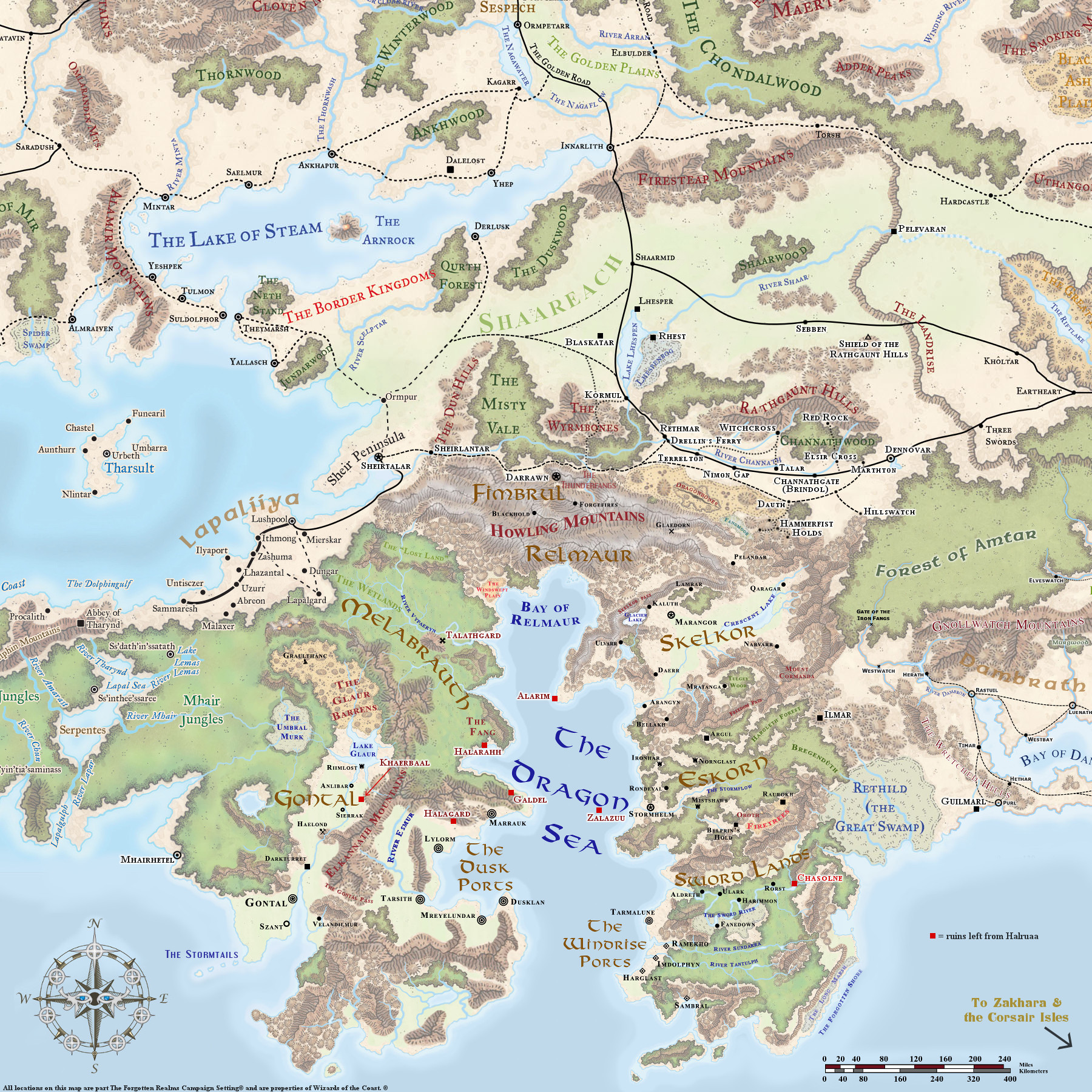
This is the base for a series of historic maps. I may or may not be putting any of the work into that part of the project (this was done to facilitate someone else's projects). It may not look like much - I still need to add the rivers, and I'll be 'painting-in' color swatches for the hills, mountains, and forests (the reason for that very basic approach is because of the nature of the intent - those things have changed over time, and this will be used for a bunch of different periods). However, despite its very 'bare bones' look, it took a LOT of time - the scale is immense (and yet still much smaller than my main mapping project). I wanted as much detail as possible, and still be able to show a MUCH larger area than any previous FR map ever done. This is just a WIP (aren't they all?) - I will be adding all the rivers over the next few days, and then its on to the terrain textures. I'm not set on the color palette - I may want to change it up quite a bit from my usual colors. The beuty of the way I did this is that there are about 50 layers just in what you see here, bare as t is. That way, I can change anything on the fly (so much more work on the front-end, but much easier to work with as we proceed). I also noticed I missed one island chain - the 'Red Rocks' near Waterdeep. They'll be on the next update.Related content


Comments: 5

Is there any chance you could post the full .PSD file anywhere? This would be an excellent resource for the FR community.
")
👍: 0 ⏩: 1

GIMP uses xcf file format. I believe PS formats are compatible with GIMP (it converts them), but I don't know if there is any backwards-compatibility. Either way, this is far from finished, so it would be awhile before I even had a finished file to post. I just made major changes to the layer masks yesterday.
👍: 0 ⏩: 0
There was some 'fudgery' in a couple of places, where I had to backwards-engineer 3e stuff into the 1e/2e/5e map layout. 3e added a bunch of stuff - especially rivers and lakes - and I had to allow for that in this map. Also, as an artist, I made a few 'artistic decisions' regarding certain other things; for example, I like the way Tharsult looked in 3e over other editions, so I went with that version. The actual outline of the continent(s), and most of the geography, was lifted straight off the Fonstad Atlas map. I also added more islands to the chain along the NW edge - Ed Greenwood had a bunch of island chains to the west of Faerûn, but because of Evermeet, Maztica, that continent North of Maztica, etc., I couldn't put them where he had them, so I moved them into the far north instead. There is an ocean current that travels clockwise in a circle around the Trackless sea (thats canon, from the Maztica boxed set), so there is a very warm ocean current traveling along those islands, making them habitable (like Iceland or maybe Greenland). That current 'cools' as it travels across the northern ocean towards Faerûn, and on down The Sword Coast, until it gets around Calimshan and then heads back West (where it picks up heat again from being in the tropics). So what that all means is, we could still use some of Ed's lore for his island chains (Eskember, Anchoromé, etc.) despite them being moved so far north now.
👍: 0 ⏩: 0

Truly excellent work. I can't wait to see the series based on this develop!
👍: 0 ⏩: 0

As you intended it's seems the most complete Faerûn map I've seen so far. Most are cropped way more (the old City of Waterdeep Trail map is probably closest to this).
I will certainly follow the next steps with interest.
 (Smile)")
👍: 0 ⏩: 0