HOME | DD
 tard15 — New WIP World Map

#alienplanet #alienworld #biomes #continents #alien_world #world_map #alien_planet #hadleycells #weather_patterns #worldmap #hadley_cells
Published: 2018-02-04 06:22:42 +0000 UTC; Views: 1085; Favourites: 12; Downloads: 7
Redirect to original
Description
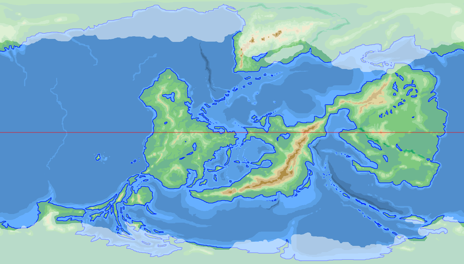
Ok, so i fell out of love with my continents on my earlier map seen here (tinyurl.com/y7rkkcp8 ) and all earlier variations linked within - though i have kept Raastayn Island! (Smile)") - and decided to basically start again.
- and decided to basically start again.There were things that i wasn't happy with with the earlier version, which i have corrected on this one (some of the things i decided that i wanted, was no - or almost no - land at the poles, a long skinny north-south stretch of land - which i've gotten with continent B, and a lot more land down near the south pole so that i could have a nice lot of tundra on both ends of the world).
I've presented several different views of my new world - showing (a) basically just the continents and poles, (b) continents with ocean and air currents, and (c) Biomes.
I'd really appreciate it if people with experience with world-building/drawing their own alien worlds could lend me their opinions on the "accuracy" of my biomes layouts and the like.
I haven't presented a view of my tectonic plates, but i'll link to that from Stash if someone wants to see it. Basically though, the main point of interest there (IMO) is that stretch of desert on continent D that points towards that southern gulf*? It's there because it is essentially a dried up Mediterranean equivalent. The north-east and south-west halves of the continent only came together recently (geologically speaking) and haven't yet formed mountains. (in fact, they might even be in the process of coming apart again, which will (re)flood the depression - i'll decide if i'm doing that once i work out placement of countries, and decide i want a disaster to befall someone (
") )
)*as to that southern gulf on continent D, i realize now (having wrapped my map round a globe) that I should probably ice it over... it has no out/inflow to warm water.
One other point of note: those 3 red dots on continents A and B? They line up. Those two continents once joined along those points. (i actually cheated a tad, and between those points is actually the east coast of Africa, re-purposed
)all opinions/suggestions/advice requested and considered!
Related content


Comments: 6

I like what you've done with this new map. A very slick techy look to it.
For the most part, I agree with your placement of biomes. A few quibbles about the desert areas on Continent B because of the wind and sea gyres you have indicated on your auxiliary map. Nothing major, but considering the placement of the desert in the south-west coastal of B, which is very close to a warm sea with a north-westward air flow, it's probably going to receive a rather heavy rain fall at times and may be subject to fairly frequent seasonal tropical storms.
Also, based on the prevailing winds, the south-eastern corner of the tropical forest of Continent B might be rather arid, not necessarily a desert, but certainly receive far less rainfall than a typical rain forest. Depending on the altitude, you might see a shift to hardy pines and scrub bush dominated savanna climate, or (if high enough) a rocky grassland dominated by river-killer trees like Aspen. The region around Atlanta, Georgia, in the USA is in a similar placement and it is often plagued by droughts, yet still typically said to be temperate in climate.
And, the intramontane savanna of Continent B would likely have a region along the mountains with fairly regular and heavy rainfall along the southern end of the central ridge. Not enough to establish a large wet zone, but enough to feed water into the biome at the southern end of the savanna. So, likely another long transitional zone from very dry at the northern end where it is encircled by mountains and quite moist at the southern end where it abuts the sea.
I see what you mean about the southern gulf on D. Very likely, it would be seasonally choked with ice floes or maybe a portion covered by permanent ice shelf. A lot would depend on how much warming occurs during solar maximum and is brought to the region by the prevailing wind gyre over the northern half of the continent. But I can easily image a hostile climate similar to that of Tierra del Fuego throughout the zone.
Also, to consider is that the temperate forest you have indicated on D is on the dry side of the mountains based on the wind, it would likely be temperate in climate but seasonally receive less moisture than a typical temperate forest, so likely would host a mix of scrub, water-hardy bushes and trees of the temperate variety. Maybe a transitional sort of affair going from wet in the south to dry at the north. The coastal plain of the Carolinas of the USA are in such a zone and are largely dominated by heat-resistant pines in the coastal plane. They receive a fair amount of rain fall, but the prevailing winds are from the west, thus lose their moisture on the wrong side of the Appalachians for a wet belt, so even though the coastal plain of the Carolinas receive a fair amount of precipitation, they do not often see heavy rains unless a tropical storm moves north of the usual belt.
These are all quibbles, not criticisms. After all, quite a lot of the Earth does not fit neatly into defined biomes and some atypical climate areas exist because of things like the Gulf Stream. That spot north of Continent E, for instance, the place where the warm ocean current intersects the cold ocean current. I am fairly certain you'd see a Sargasso Sea sort of affair in the junctional gyre and summer ice floes moving along the western coastal area of Continent A. Picturesque to be certain, but likely an overall chilling effect for the western coast of A. So perhaps the Boreal Forest would range a bit farther south along the coast. Again, only a quibble.
You have done well.
👍: 0 ⏩: 1

see, this is why i like detailed replies, i makes me think more, and i notice little "errors" ... so thanks again.
As you say here and in other comments, there are no real hard and fast rules - or at least Earth breaks them happily enough - so i can be a bit flexible...
I get completely your comments about continent D, and indeed that apparent almost flaw mainly comes down to my not showing transitional zones - also, it may not be all that visible, but there is a narrow Chaparral/Mediterranean zone around the shoreline of the sea between B and D, so yes i was indeed intending that temperate forest to get dryer to the north.
I was of the mind to shorten the cape to the east of D's southern gulf to remove my problem
Continent B's savanna is also victim to my not showing transitional zones, coz yes, you've read my mind - transitioning to almost temperate forest down near the south coast is what i had in mind. I'm also considering making this the site of one of my major rivers of the world - one with an actual source, but also fed by rivers from the mountains on both sides of the wide valley - sort of like the Amazon or the Nile.
As to B's southern desert, i take your point and agree - (looking at the map now, i actually aren't really sure *why* i put that desert there at all... i was kind of going by Earth "rules" regarding deserts by putting them on the western side of continents, and near the ±30° mark, but that particular desert doesn't obey that rule. hmmm.) - It should probably have a similar climate zone to the north of Australia's Northern Territory thanks to the Monsoon season. Hardly verdant rolling hills, but plenty of hardy plants. Maybe a narrow strip of tropical rainforest along the coast, dwindling back to savanna towards the mountains. If anything, if i must have desert it should probably swap to where the grasslands are now. What would you think of that?
Of course, in all cases my placement of biomes is really just so that, when i get around to placement of rivers and national borders, that i don't implausibly place too-high populations in arid areas that just can't support them.
Thanks again as always for your thoughts, and while I'm going to have a small break from this map (I've got some other works that have a more pressing deadline that have to be met), i do think that I am at a point where i can start putting in the details now.
Thanks muchly!
👍: 0 ⏩: 1
For what little help I might have been to you, you are most welcome.
I have had a few days to look at this and think and look at it again. The cold water current that passes between B-D and E seems to me a little odd, so I dwelt on that, trying to think of how the water might be made to conform to your pattern.
The long and the short of it is this: The submerged uplift that the chain of islands running from the B-D isthmus to E is on would have to have a substantial trench bisecting it for the deep cold current to keep to your pattern. This would likely result in some manner of weather irregularities. The trench would necessarily be narrower than the deep cold current, so some degree of cold water upwelling would have to occur. I think regular occurrences of heavy fog at the very least and vile weather in general as tropical air intersecting cold water upwell is hardly ever a stabilizing thing for weather (there is a area off the eastern coast of Canada with a similar alignment of cold water meeting generally warmer air, Titanic was a victim of the thick fog + icebergs on that one, but your location is too far south for icebergs, so just fog).
This chilling effect would also to some degree explain the general chilly climate of the embayment on D - due in part to the intersection of the deep cold current with the antarctic circumpolar current, but also due in part to the nasty weather that the southward flowing deep cold current would churn up in the upwell zone. The best I can contrive in my imagination is Arkhangelsk with plenty of fog and rotten weather even in summer.
Again, only a quibble, not an error finding. Truth be told, you could simply say there are volcanic hot springs feeding the embayment and say it is atypically warm for its position. There's certainly enough plate collisions there to justify it .
👍: 0 ⏩: 1
thanks for you comments (and they have been a help, even if just to confirm that i'm on the right track and am reading the information that i'm researching correctly)
Regarding that cold water current... to be honest, the currents map was put together a bit slapdash... i basically just knew that i needed circulating currents so i just slapped it together in as close to circular patterns as i could - that current probably should have warmed up again as it crossed the equator, but... ah well, it didn't. -- But it's good to know that there is a version of reality that supports its existence. ...and not only that, but when i looked back at my Tectonic Plates map look what i saw...
That chain of islands is indeed bisected by the boundary between plates. I hadn't intended to make a trench there... but there is one there now.
BTW - The lower case letters on the Plates refer to whether they are primarily Continental or Oceanic plates.
also, i know that these Plates make a bit of a nonsense of the undersea topography surrounding the continents (especially the bit between the island on Plate L and Continent A), but again, that was put together roughly... it is the Plates that are correct. Bathymetry will be corrected on the final map.
👍: 0 ⏩: 1
The Labrador Sea Current begins above Greenland in the Arctic Sea, passes through the strait above Baffin Bay, down the Davis Strait, picking up icebergs calved from Greenland's western glaciers, then the Labrador Sea Current carries them south onto the warm North Atlantic Current, which sends the icebergs conveyor-belt style towards the gap between Iceland and Ireland. Note that the Labrador Current turns 90-degrees west at Cape Race of Newfoundland, then hugs the coast of New England, which is counter-intuitive for a collision with a east-ward flowing warm current, but there you have yet another example of natural world weirdness.
Looking over the plate map you linked, many things have become clear. It's not all uncommon for a cold, salty current to pass through the equatorial zone largely unheated. It depends on depth, of course, and abyssal sea trenches certainly work to facilitate this. So, slapdash though they may have been, I would say there is nothing wrong with your system of sea current gyres.
👍: 0 ⏩: 1
you're right about real-world weirdness
...but it's good to know that i'm mostly on the right track with things, and not getting anything glaringly wrong.
Like i say, my land and water Biomes are really just so that i don't have too many implausibly large civilizations (or just too many countries ) in areas that can't support them.
I'm about a third of the way through my more pressing artwork that is keeping me from this map, so i should be back to it soon(ish)
I look forward to your critiques once i get going again
👍: 0 ⏩: 0