HOME | DD
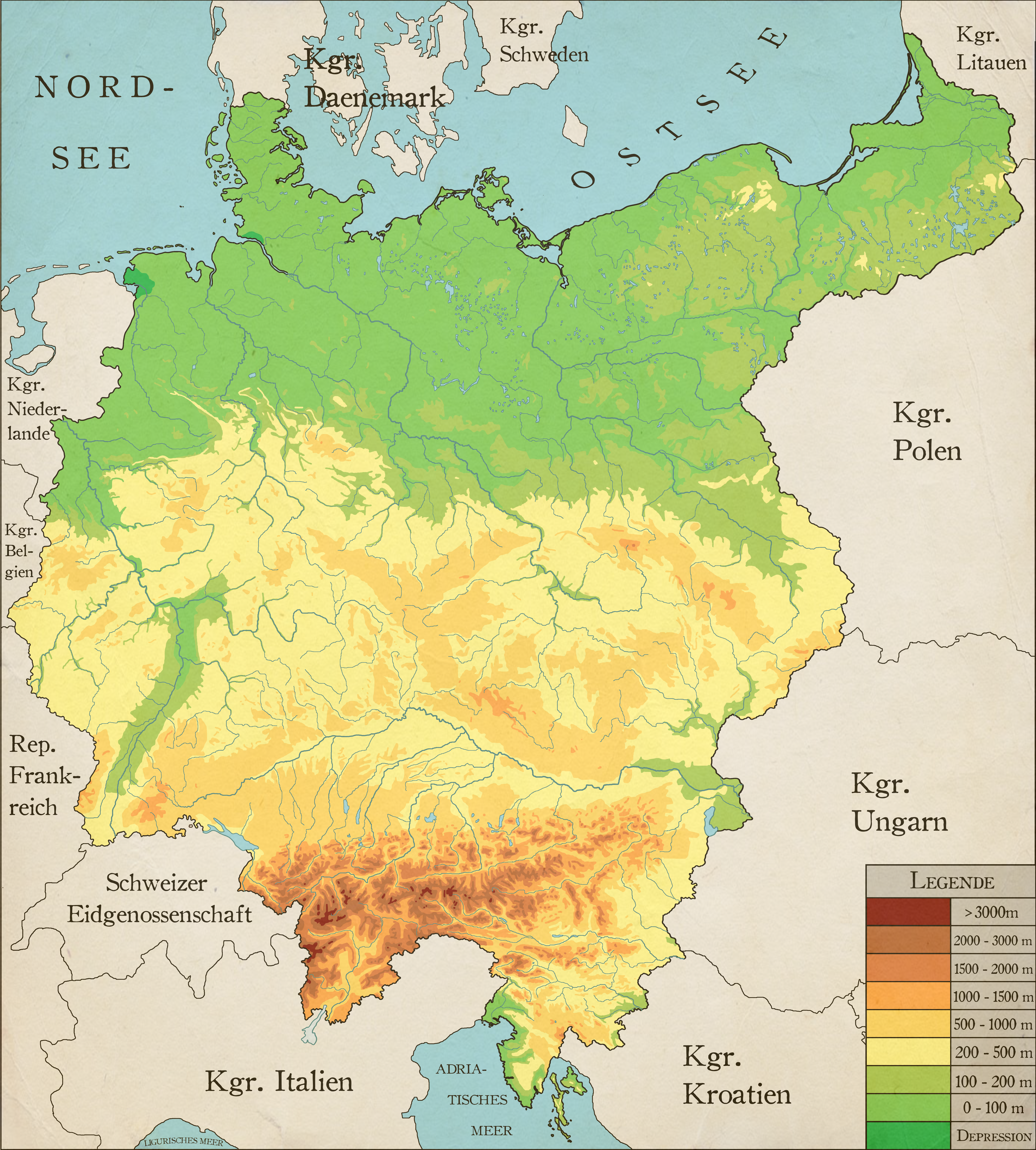
 Robeatnix — Greater Germany Physical Map
#alternate #geography #germany #greater #history #map #physical #reich
Published: 2018-03-10 02:08:28 +0000 UTC; Views: 13052; Favourites: 154; Downloads: 112
Redirect to original
Description
Physical Map of Greater GermanyA map illustrating the physical landscape of Greater Germany from the Weltenbrand scenario
I also made a version with cities, another one with cities and peaks and another one with cities peaks and mountain ranges, so if you like this map you can check out those to.
If you like the map or have ideas on how to improve it, feel free to comment. Constructive criticism is always welcome.
Related content


Comments: 25

👍: 0 ⏩: 0

👍: 0 ⏩: 1

👍: 1 ⏩: 0

Sehr schöne Karte. Das ist glaube ich das erste mal, das ich Großdeutschland in einer physischen Karte betrachten kann. Könnte nicht noch Limburg dazu gehören, das es wie in der ersten Strophe ist: Von der Maas bis an die Memel, von der Etsch bis an den Belt
👍: 0 ⏩: 2

Great map. If I could suggest any changes, it'd be to add New East Prussia, South Prussia, New Silesia, Teschen, and the arrondissements of Briey and Belfort.
I have a timeline involving 1871-borders Germany, an alt-Schleswig border, Briey and Belfort, 1919-requested Austria with Preßburg, Ödenburg/Sopron, Sudetenland, Geeman Bohemia, Teschen, South Tyrol, and the three Ladin communities (Cortina, Colle Santa Lucia and Livinallongo) that this kind of map would be perfect for.
👍: 0 ⏩: 0
Deswegen habe ich die Karte auch gemacht. Ich konnte einfach keine gute, detaillierte Karte von diesem Bereich finden. Limburg habe ich nicht rein genommen, da es nicht Teil des Deutschen Bundes war und weil dieses Land ein Nachfolgerstaat des Deutschen Reiches sein soll, welches nach dem gewonnenen Ersten Weltkrieg und dem Zerfall Österreich-Ungarns die (zumeist) deutschen Teile anschließt.
👍: 0 ⏩: 1
Achso, wenn es ein Nachfolgestaat des Kaiserreiches sein soll dann macht es Sinn. Limburg gehörte ja nicht zum 2ten deutschen Reich. Aber ich bin mir ziemlich sicher, das Limburg ein Teil des deutschen Bundes war.
👍: 0 ⏩: 1
Anscheinend schon (seit 1839), mein Fehler.
👍: 1 ⏩: 0

Fantastic map!
I admit I thought central Bohemia would be lower and the eastern part of Germany not quite so flat.
👍: 0 ⏩: 1
Thanks.
Bohemia does have a pretty comfy position, since it is surrounded by mountains on all sides.
👍: 0 ⏩: 0

I've never noticed that large valley in the west before.
👍: 0 ⏩: 1
That's the Upper Rhine Valley. The region is known to have to mildest climate in Germany and is a major wine-producing area.
👍: 0 ⏩: 1
It looks like it was carved out with a massive flood after an ice damn broke and a massive lake was emptied. Reminds me of the Willamette valley in Oregon.
👍: 0 ⏩: 1
In the case of Williamette valley this is actually true. In the case of the Upper Rhine Valley however it was caused by the the collision of the African and the Eurasian Plate which also created the Alps.
👍: 0 ⏩: 0
The checz used to be very Germanised right?
👍: 0 ⏩: 1
The Czech borderlands were inhabited by Germans and the nobilty was German and spoke German. Up until WW1 the German language was equal to the Czech languages, which was mostly spoken by the peasants. So you could say that many Germans lived in Bohemia and thier rulers were German. For the most parts however Bohemia was still Czech.
👍: 2 ⏩: 1

Omg this is brilliant, this looks damned great!
Maybe you can do a version where u add the most prominent rivers and cities as well?
👍: 0 ⏩: 2
I added the rivers. Hope you like it.
👍: 0 ⏩: 1
Thanks. I was already planning to do that.
-> See description
👍: 0 ⏩: 0
Thanks man. Do you think the paper background should be more dominant or not.
👍: 0 ⏩: 1

I think it's fine how it is
👍: 0 ⏩: 1